The posted coordinates will bring you to a beautiful spot along the Sooke River which we love visiting. It may also be a busy summer spot. Please beware the rocks can be slippery, and respect nature and leave no trace behind.
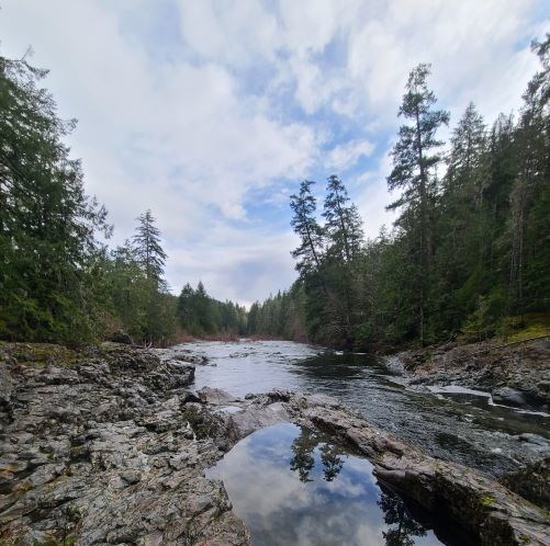
The last ice age, 14- 15,000 years ago, glaciers that covered Vancouver Island started to melt and recede, they carved through rock creating this canyon-like water way through parts of the Sooke River. The ice also caused fissures in the rock resulting in large boulders being deposited, as you see today. These boulders have played a role in forming the Sooke River and Potholes.
What Causes Potholes?
Pothole landforms can be a hole in exposed rock, or caused by river currents. Potholes can also be referred to as swirlholes. Potholes can be a variety of sizes from a few inches wide and deep to several feet. Some potholes can be as big as 300 feet wide and 50 feet deep.
Potholes are formed by erosion on a layer of exposed rock, from water, rocks, wind particles, algea, fungi and bacteria. The erosion causes depressions in the rock, which catches the sediment, pebbles and other material as it is carried down the river, and the water turbulence causes the pebbles to spin around and erode the rock into a hollow. The hole becomes bigger as larger debis becomes trapped, and further erodes the hole.
The Sooke Potholes were formed by glacial and water erosion. There are many rapids, waterfalls, and many deep, clear potholes, which makes popular summer swimming spots. Depending on the time of year and rain, the river can be raging and the potholes hard to observe. The posted coordinates potholes are down the river from the main viewpoint and are available year round.
The coordinates will bring you to an area with several potholes to observe. The largest pothole nearby are what the questions are based on. This is available year round.
Logging this Earthcache
To log this Earthcache please message us your answers. Once your answers are sent you can log the Earthcache. Please send your answers and log the Earthcache on the same day. Please do not post any answers in your log and don't post pictures that provide answers to the below questions.
1) What is the length, width and depth of this pothole?
2) What evidence do you see that suggests how this pothole was formed?
3) Describe the rock around the pothole. What type of rock do you think this is?
4) There is evidence of glacial activity in this area. What direction was the glacier travelling according to the glacial striations?
5) Post a picture of yourself or personal object.
Resources: Wikipedia-Pothole(landform)
VI Wilds; Worldlandforms.com
