Silver Bluff Geoart - Wood Stork 14
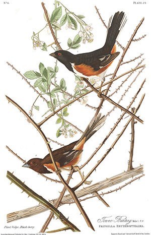
Towee Bunting
Please read through the Searching Guidelines below before heading to the geocache.
There is import information to keep geocaching in good graces with the management.
Plate 29 Pipilo erythrophthalmus
"The flight of the Towhe Bunting is short, low, and performed from one bush or spot to another, in a hurried manner, with repeated strong jerks of the tail, and such quick motions of the wings, that one may hear their sound, although the bird should happen to be out of sight. On the ground, where it is more usually to be seen, it hops lightly, without moving the tail more than the Common Sparrow of Europe. It is a diligent bird, spending its days in searching for food and gravel, amongst the dried leaves and in the earth, scratching with great assiduity, and every now and then uttering the notes towhee, from which it has obtained its name. At other times, it ascends to the top of a small tree, or its favourite low bushes and briars, on which it sings very sweetly a few continued mellow notes." John J. Audubon
Please solve the puzzle in order to obtain the coordinates for this geocache.
Final Location is: N 33° 20.ETO W 081° 51.WÉË
Eastern Towee or E. Towee, which works better for the puzzle.
What scientists called the Towee Bunting in Audubon's day is contemporarily known as the Eastern Towee. This species uses a number of different calls, each of which can be used to identify the bird when hearing it. A couple of the calls seem to include the bird's name, "towee."

Since this is a letterbox hybrid, the review process requires a note that there is a stamp inside that is not a tradable item.
Silver Bluff Geoart Information
The geoart was created at a sanctuary in the area along the Savanna River called, Silver Bluff. The sanctuary is open from dawn to dusk, and permission for this hide was granted by the sanctuary manager. If you encounter sanctuary personnel during your visit, please be open and mention that you are geocaching. The geoart consists of 55 geocaches in the shape of a wood stork. This sanctuary annually has hosted the largest inland concentration of foraging endangered wood storks in South Carolina. There were some caches already existing at the sanctuary, and they were incorporated into the geoart. The difficulty/terrain ratings of the 55 geocaches are all different and provide a diverse geocaching experience. When combined with the related geoart of 26 geocaches, all 81 possible D/T ratings are included.
Searching Guidelines
As you are searching for Silver Bluff Geoart caches, please follow the following guidelines.
- Parking along roads: There are dirt roads in the area. They are not heavily used, but please be careful. Please do not block the roads or park on the roads. Be sure to pull off of the dirt roads completely. Please do not park near the gate at the end of Silver Bluff Road. Also, do not walk past that particular gate. Use the Quail Trail to access the caches at the south end of the sanctuary.
- Access to Authorized Personnel Only Areas: You are authorized to go past the signs that say, "Authorized Personnel Only" when searching for geocaches. Near the main office, there is a dirt road that has such a sign. There are some Terrain 1 (wheelchair accessible) caches down the road, and people are welcome to drive down that road into the authorized personnel areas for disability access. If you are asked about entering that area, just kindly mention that you are a geocacher who needs to take advantage of the disability access.
- Birdhouses: There are many birdhouses in the sanctuary. No geocaches are hidden in birdhouses and there are no fake birdhouses. There might be some containers attached magnetically to the metal baffles below the birdhouses or on the ground by the birdhouses. Please be careful when approaching birdhouses, because there might be birds actively using them in the spring.
- Main Office, Trail Heads and Parking: You are welcome but not required to stop by the main office during your visit. Access to the trail heads is from the main parking area. There is also parking at Kathwoods providing access to the walkways around the ponds.
John Audubon Drawing Information
The image on the cache page is from the original drawing by John James Audubon and was printed between 1827 and 1838. The description of the bird on this cache page is an excerpt from the original entry in Audubon's field guide. An Internet search of the bird name and plate number will enable you to locate the complete information about the bird as originally written by John Audubon and locate a high resolution image of the plate. A direct link is not provided with this geocache because it was deemed that doing so had the appearance of commercial content on the cache page.

You can validate your puzzle solution with certitude.