Welcome to the West Highland Creek Mass Wasting Earthcache. Please read logging requirements as set out below in order to log a find. Please send me an email with the required information, and do not post any answers in your log. Pictures are always encouraged, however, be sure that they do not give away any of the answers! Parking has been waypointed.
West Highland Creek is tributary of Highland Creek in the Lake Ontario drainage basin. The creek and its tributaries provide the watershed for the northwest of the old city of Scarborough.
The posted coordinates will bring you to a bridge. When looking North from the bridge, one can see that an unnamed tributary creek from Curran Hall Ravine joins the West Highland Creek. You will also clearly see the slope to the North, and that is the focus of this earthcache.
What is undercutting?
Undercutting if the erosion of material at the base of a steep slope, cliff, or other exposed rock.
What is mass wasting?
Mass wasting is the downhill movement of rock and soil material down a slope due to gravity. The term landslide is often used as a synonym for mass wasting, but mass wasting is a much broader term referring to all movement downslope. Geologically, landslide is a general term for mass wasting that involves fast-moving geologic material. Loose material along with overlying soils are what typically move during a mass-wasting event. Moving blocks of bedrock are called rock topples, rock slides, or rock falls, depending on the dominant motion of the blocks. Movements of dominantly liquid material are called flows. Movement by mass wasting can be slow or rapid. Rapid movement can be dangerous, such as during debris flows. Areas with steep topography and rapid rainfall are particularly susceptible to hazardous mass-wasting events. The chart below, which was made by firennice, shows the different types of material, and their nature of motion.
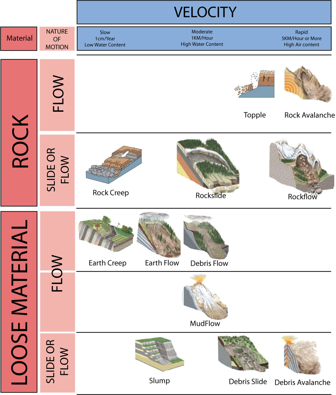
Topple: Is where a large rock, series of rocks, or blocks fall away from a slope. This is very common in many areas where stone is worn away, especially under other stones. Eventually the heavy stone above it will weaken and just topple over. Sometimes rolling down a slope. They can be identified by the few stones that have fallen laying about.
Rock and Soil Creeps: These are slow, taking a long time. In fact they may be difficult to pinpoint. They move slowly dowhill with gravity slowly pulling on them. The steeper the slope the faster the creep. Sometimes they may turn into land or rockslides. This tends to be why hills are rounded. Think of taking a cone, filling it with mud and turning it upside down. You can do this with dirt, but the mud is faster and more dramatic. Holding together to dome outward.
Rockslide, mudslide, or debris Flow: These are moderately fast slides of of rocks, or other debris. They are common after storms or in a fire area where the water loosens the material and send it downhill. Mudslides and debris flows are espeically common after a fire. The fire removes much of the plant life that holds the soil in place. A sudden buildup of water in the soil can cause it to move down the slope in mudflows or debris flows. There will be debris area for them, quite often in fan shapes at the base, where they flow outward.
Rockflow or Avalanches: These are rapid and large movements of materials. The material may cascade rapidly downhill and cause a vast amount of damage. A Rockflow is tumbling of just rock down a hillside, Rock Avalanche is similar with a lot of soil includes, while a debris avalanche tends to be made up primarily of finder materials. These tend to have large rockfall, debris fields
A slump: This is a weakening of the soil on a slope, it causes the soil to slide away. Not as slow as a creep that the movement may take decades, but not as rapid as a debris flow. Usually caused by a lot of water loosening the soil then in a process that may be fairly rapid, or a few inches a day it will slide. Usually it will will just drop. A quick way to tell if it is a some other ground flow and a slump is how trees may fall. In a slump they typically fall backward, the roots on the downward side. The deep slumping of the ground pulling it down and and the roots forward. In many other flows trees are still deeply anchored and pushed over from the uphill. Causing the roots to be uphill.
In order to log this earthcache, please email me the answers to the following questions:
1.Describe the slope. What do you see? What material is the slope comprised of?
2.Do you see any evidence of undercutting? If so, what do you see?
3.Using the chart above, what you have read on the cache listing, and on-site observations, what type of mass wasting movement can be seen here? Please justify your answer.
4. Include a photo of yourself or an item of yours on the bridge, showing what is to the SOUTH.
Congratulations to drdavev on the FTF!