New River Canyon Earthcache
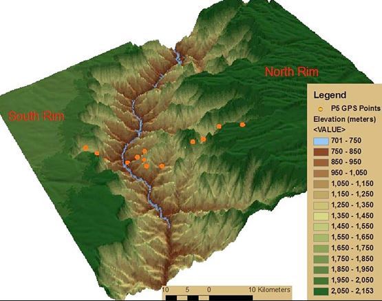
Welcome to the newest addition to the list of National Parks, New River Gorge National Park. This Earthcache will take you on a very scenic hike to an even more unique geological feature here in West Virginia. The hike to the earthcache is approximately a mile along the Endless Wall Trail. A roundtrip hike would be consistent with around 2.8 miles on Endless Wall Trail and along highway 82 to get back to the parking lot you started from. There is a little trail beside the road that can be used to walk on, parts can be kind of rocky though. From trail head to trail head, the length of Endless Wall Trail is about 2.4 miles. There is parking available at the posted waypoints - at both trail heads along Highway 82. The Canyon Rim Visitor Center is also nearby and is recommended to visit for more information about the park, trails, and a rest stop.
The New River
The river through the gorge - commonly referred to as "The New" - is the only River to run from East to West across the Appalations (also flows North during the first portion of the river) and the second oldest river in the world. When you look out over the New River Gorge, one cannot help but notice the steep, v-shaped canyon walls and sandstone outcroppings- the Endless Wall of rocks. It was caused by erosion over a very long period of time. The New cuts through the Appalation Plateau and exposes 3200 feet of sandstone and shale. Many hypothesize on the age of the river, but it is thought to be older than the Appalation Mountains themselves. When the mountains were uplifted by techtonic events, the existing New River began continuosly cutting through the newly formed mountains slowly creating the Gorge seen today. This is also one of the reasons The New is one of the only rivers to cut through the Appalations, instead of flowing on or from the mountains.

Canyons
A canyon is defined as a deep, narrow valley with steep sides typically created by the movement of rivers, the processes of weathering and erosion, and techtonic activity.1 Although canyons may form in the presence of multiple processes, typically the canyons we think about (Grand Canyon, Antelope Canyon, etc) are the product of erosional forces from water over vast amounts of time. Rivers gradually cut away at the underlying rock layers eventually leaving sharp clifts of weather and erosion-resistant rock strata.2 A gorge is a narrow valley with steep, rocky walls located between hills or mountains (sounds a lot like a canyon, right?). A gorge, however, is often smaller than a canyon, but both words are used to describe a deep, narrow valley with a stream or river running along the bottom.1 Typically the term canyon is used in the Southwest US and gorge is used in the Northeast, primarily due to the entymology of both words- spanish-speaking Mexico and French Canada, respectively.2 Generally the terms used is dependent on geographical location.
There are generally three types of canyons: Plateau canyons (commonly referred to as mountain-type or river canyons), Box canyons, and Slot canyons.1,3 Personally, slot canyons are my favorite, mainly because they are intriguing, picturesque, and there is one relatively close to where I live that originally piqued my interest in canyons and Earthcaches in general. There is also a fourth type of canyon called a submarine canyon that can be found under water on the sea bed, but these are generally formed by different geological processes.1,2,3 There exists yet another type of canyon, but you would have to travel all the way to Mars to enjoy this extraterrestrial beauty - Valles Marineris. This canyon is described further down toward the bottom.
Box Canyons
A box canyon is a small, steep walled canyon that is generally shorter and narrower than a Plateau canyon. There is normally one point of entry to a box canyon, which also serves as the only exit. Steep walls on all sides and only one way out and in makes the observer feel "boxed" in. Box canyons were previously used as natural corrals in the western United States by ranchers. They would lead their animals in and have their entrances fenced.2
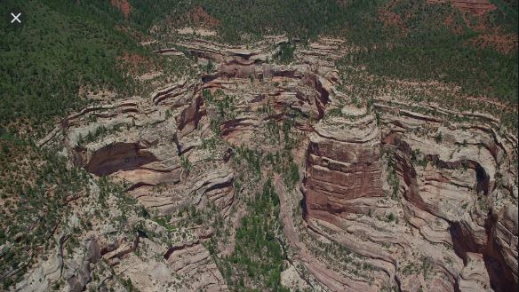
Plateau Canyon / Mountain-type Canyon / River Canyon
The most familiar type of canyon is the Plateau Canyon. They are the result of erosional forces exerted on rock by rivers or other moving water.1 The water pressure from a river continuously cuts into the exposed river bed carrying sediment downstream leaving a deep and sometimes narrow channel. These rivers are regarded as 'entrenched' rivers as they do not meander or change their course due to being entrenched between walls of the canyon they have previously cut into.1 Other outside forces, such as weathering, erosion, tectonic uplift, etc. may contribute to the canyon formation.
The best example of this type of canyon is the Grand Canyon - one of the 7 Natural Wonders of the world. Clocking in at a whopping 277 miles long, 18 miles ride, slightly over a mile deep, and 5.45 trillion cubic yards of volume, the Grand Canyon is a product of tectonic uplift and the gradual erosion (5 - 70 millon years) from the Colorado River leaving a massive chasm and an entrenched river at the river bed.1,4


Slot Canyon
These types of canyons are long, very narrow, deep and tortuous channels with sheer rock walls that are generally eroded into either sandstone or other types of sedimentary rock. These canyons are so long and narrow that their exposed top (or gash in the ground) may be 3 feet across but drop more than 100 feet to the canyon floor below.5 These canyons are primarily formed in sandstone and limestone when brief, heavy rains cause water to rush down cracks in rocks causing them to crumble and fall.1 These softer rocks cause the opening at the bottom to grow much more rapidly than the top of the opening which results in an opening at the top 3 feet or less and a bottom that plunges a hundred feet or more.
Sometimes this phenomenon can be hazardous as sudden, heavy rain (even from distant locations) can cause flash flooding of the entire canyon.2 These canyons will have a nery narrow opening very far above with no point of egress for long spans along the length of the canyon making it near impossible to escape in a flood event without a preconceived plan in place. Care must be taken when traversing and visiting these types of canyons.
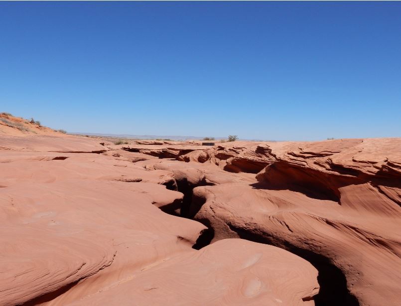
Due to the nature of these canyons, they may often be overlooked from above. When they canyon is accessible, like upper and lower Antelope Canyon in northern Arizona, the result can be breathtaking. Travelers from all over the world visit this canyon in anticipation of marvelous views from the canyon floor including smooth, orage walls, isolated beams of light, falling sand, and other points along the canyon floor.

Valles Marineris
Valles Marineris, or Mariner Valley, is a vast canyon system running along the Martian Equator spanning approximately one QUARTER of the Martian circumfrence.6 This canyon is 2500 miles long and reaches depths up to 4 miles, making this canyon the largest canyon in the solar system!6 Just for comparison, the Grand Canyon is about 500 miles long and only 1 mile deep ('only' being a fluid term when in reference to Valles Marineris  )
)
Interactive Mars Visual

The jury is still out on how the canyon was created with researchers having varying opinions. Most researches agree that Valles Marineris is a large tectonic "crack" in the Maritan crust, forming as the planet cooled, affected by the rising of the region to the west and later widened by erosional forces - whether that be water, lava, or something else entirely. The region to the west, the Tharsis region, contains several large volcanoes that pushed molten rock through the volcanic reagion causing a upheaval in the crust. The strain from the crust heaving upward caused a massive crack and subsequently causing large faults and fractures across the planet's surface. These fractures, growing and eroding over time, birthed the enormous canyon system.6,7,8
These spreading cracks caused the ground to sink under the pressure from the mounting volcanic activity and opened an escape for subsurface water. The upward rushing water eroded the edges of the fractures, enlarging them and washed away more of the ground while flowing past the fractures. Lava flows and landslifes have also played a role in enlarging the features of the canyon.6


To Log This Earthcache
In order to demonstrate the education value of the Earthcache, please send your answers and any supporting evidence to the cache owner in the form of a "send answers" log on the smartphone app or in a Message on Geocaching.com
1) Post a photo of yourself (doesn't have to include your face), your GPSr or other TOTT with the New River Canyon in the background
2) Based on the given information, what type of canyon would you believe this area to be?
3) To what depth does the canyon plunge within this area?
4) Valles Marineris is an extraterrestrial canyon, and has several factors possibly impacting the creation and continous development of the feature. What type of canyon would you classify Valles Marineris
5) As you are looking out over the canyon, what geological feature is evident along the East side of the Canyon? What man-made feature is evident spanning the canyon to the west?
Sources
1) https://www.nationalgeographic.org/encyclopedia/canyon/
2) https://en.wikipedia.org/wiki/Canyon
3) https://www.worldatlas.com/articles/what-is-a-canyon.html
4) https://www.nps.gov/grca/learn/management/statistics.htm
5) https://en.wikipedia.org/wiki/Slot_canyon
6) https://www.space.com/20446-valles-marineris.html
7) https://mars.nasa.gov/gallery/atlas/valles-marineris.html#:~:text=Valles%20Marineris%2C%20or%20Mariner%20Valley,km%20(1%20mi)%20deep.
8) https://www.nasa.gov/multimedia/imagegallery/image_feature_83.html