Please bring your own pen and be very discreet in this busy parking lot.
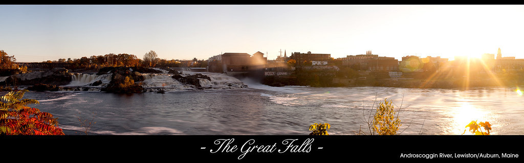
From this parking lot, you can take the short trail up to view the Great Falls.
This cache is of part of The New England Franco-Route Geotour (GT4A7). The New England Franco-Route will guide you to the places, in Maine, New Hampshire, Massachusetts and Rhode Island where thousands of French Canadians settled to work, live and create new communities at the turn of the 20th century.
Lewiston, ME is a city of about 37,000 residents and is the second largest city in Maine. In the colonial era, Abenaki bands inhabited the region. Among these were the Androscoggin tribe, which lent its name both to the region and to its main waterway. People of European descent began settling the area in the late eighteenth century.
Perhaps one of Lewiston-Auburn most iconic landmarks, the Great Falls is a must-see while visiting the area. During the spring melt, the Falls can be so impressive that they have nicked named “Maine’s Niagara Falls”. This geological formation along the Androscoggin river has figured prominently in local history. The area was first known as an important site for Native Americans for fishing. European settlers in the area were quick to harness its power to run saw mills and other industries. It wasn’t until the mid 19th century when investors and entrepreneurs from Massachusetts decided to capitalize on the Fall’s energy with the creation of canals to then in turn build impressive cotton and shoe mills, such as the Bates Mill.
Veuillez apporter votre propre crayon et soyez discrets dans ce stationnement achalandé
À partir de ce stationnement, vous pouvez prendre le petit sentier qui mène jusqu'aux grandes chutes
Cette cache fait partie du Géotour franco-américain de la Nouvelle-Angleterre (GT4A7). La Franco-Route de la Nouvelle-Angleterre vous guidera vers les endroits où des milliers de Canadiens-Français se sont installés pour travailler, vivre et créer de nouvelles communautés au tournant du 20e siècle.
Comptant environ 37 000 habitants, Lewiston est la deuxième ville en importance dans le Maine. Lors de l’époque coloniale, cet endroit était habité par des groupes abénaquis; la tribu Androscoggin laissa son nom à la région et à son principal cours d’eau. Le peuplement européen débuta à la fin du dix-huitième siècle.
L’un des plus remarquables attraits de la région de Lewiston-Auburn, les imposantes chutes du fleuve Androscoggin ne peuvent échapper l’attention des visiteurs. Lors du dégel, au printemps, les chutes peuvent prendre une telle ampleur qu’on les surnomme « les chutes Niagara du Maine ». Cet endroit, qui provient d’une formation géologique sous le fleuve, a joué un rôle considérable dans l’histoire locale. C’était longtemps un lieu où les peuples autochtones venaient pêcher. Les gens d’origine européenne qui s’y établirent profitèrent du torrent pour construire des moulins à scie puis d’autres industries. Ce ne fut qu’au milieu du dix-neuvième siècle que des entrepreneurs et des investisseurs du Massachusetts tentèrent à leur tour d’en tirer profit. Ces capitalistes financèrent la construction de canaux qui alimentèrent les nouvelles manufactures de coton et de souliers—l’usine Bates, par exemple.