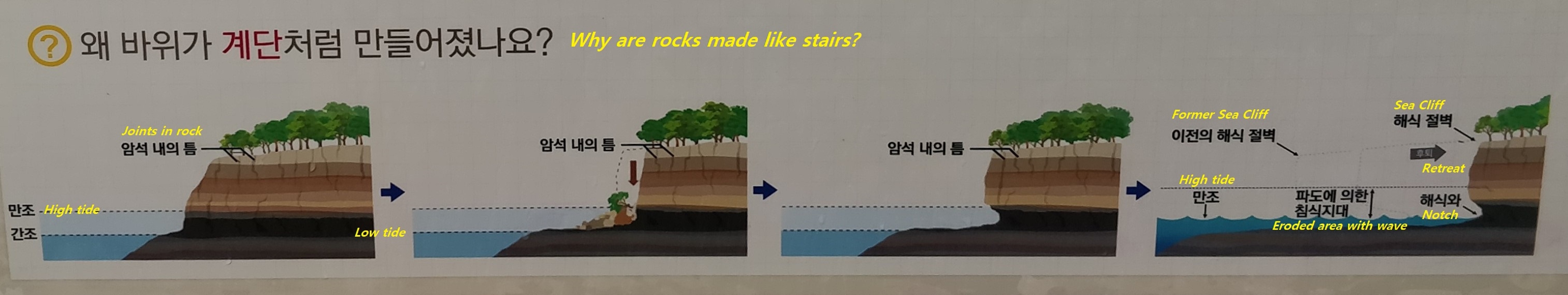
왜 바위가 계단처럼 만들어 졌나요? (Cache zone)
태종대와 같은 암석해안에서는 파도의 침식 작용과 관련된 다양한 지형들이 만들어진다. 그림에서 보는 것처럼 해수면 바로 아래의 바위들은 파도의 침식에 의해서 평탄한 파식대지가 만들어지고, 해수면 위의 바위 들은 침식되어 가파른 해식절벽이 만들어진다. 지각변동으로 땅이 융기되거나 혹은 해수면의 높이가 하강하게 되면 만들어진 파식대지와 해식절벽은 해수면 위로 드러나게 되는데, 이러한 계단형태의 지형을 단구라고 한다. 태종대에는 최소 ( )단의 해안단구가 확인 되고 있어 지각이 불연속적으로 여러번 융기된 지역임을 알 수 있다.
Why are rocks made like stairs? (Cache zone)
On rocky coasts like Taejongdae, various coastal landforms are observed. As shown in the picture, the rocks just below the sea level are made flat by wave erosion, and the rocks above the sea level are eroded to create a steep sea cliff. When the land is uplifted with some changes in the earth's crust or the sea level is lowered, the coastal terraces and sea cliffs created by waves are exposed above the sea level. In Taejongdae, the coastal terraces of the minimum ( ) stages are observed. That means that the crust is discontinuously uplifted several times.
***사진을 클릭하면 크게 볼 수 있습니다.(Click the picture to enlarge!)
해식동굴 (Stage 2)
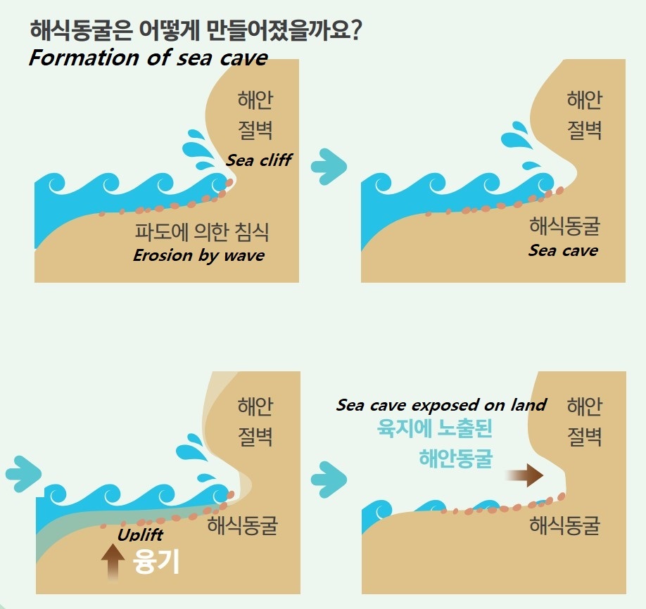
태종대의 해안절벽 곳곳에는 크고 작은 해식동굴들이 많이 관찰된다. 해식동굴은 해안선 가까이에서 파도, 조류 또는 연안수 따위의 작용을 받아 해안에 형성된 동굴. 파도가 암벽에 직접 부딪치는 해안이나 돌출부에 만들어지며, 화학적 용식작용으로 형성되는 대부분의 내륙 동굴과는 달리 침식으로 형성된다. 해식동굴은 해식절벽과 같이 산지가 해안까지 연결되어 절벽을 이루고 있어야 하며 파도의 공격이 심한 곳에서 파도가 약한 암석을 골라 지속적으로 파고 들어가 만들어 낸 공간을 만든다. 파도의 수압에 의해 확장된다. 파도의 압력은 동굴의 지붕을 통하여 보통 숨구멍이라고 하는 구멍으로 비말을 뿜으며 사라진다. 이러한 해식동굴의 침식 작용이 계속되어 동굴 윗부분까지 없어지고 나면 해식대지가 만들어진다.
Sea Cave (Stage 2)
Sea cave is formed in a cliff by wave action of an ocean or lake. Sea caves occur on almost every cliffed headland or coast where the waves break directly on a rock cliff and are formed by mechanical erosion rather than the chemical solution process that is responsible for the majority of inland caves. Zones of weakness in the cliff give way under the force of the waves and are eroded out; these cavities are enlarged by the hydraulic pressure built up by each wave. Holes, commonly known as blowholes, may eventually be forced through the roof of the cave to allow the pressure created by each wave to be released as a jet of spray.
***사진을 클릭하면 크게 볼 수 있습니다.(Click the picture to enlarge!)
동글동글 자갈마당 - 역빈 (Stage 3)
태종대 해안은 깍아내리는듯한 해식절벽들이 절경을 이루고 있습니다. 이 절벽들 사이로는 둥근 자갈이 쌓여있는 역빈(현생자갈마당)이 만들어져 우수한 경관과 함께 시민들의 휴식처로 이용되고 있습니다. 지갈은 파도에 의해 운반되면서 서로 부딪혀 깍이고 다듬어져 동그랗고 매끄러운 형태를 가지게 되었습니다.
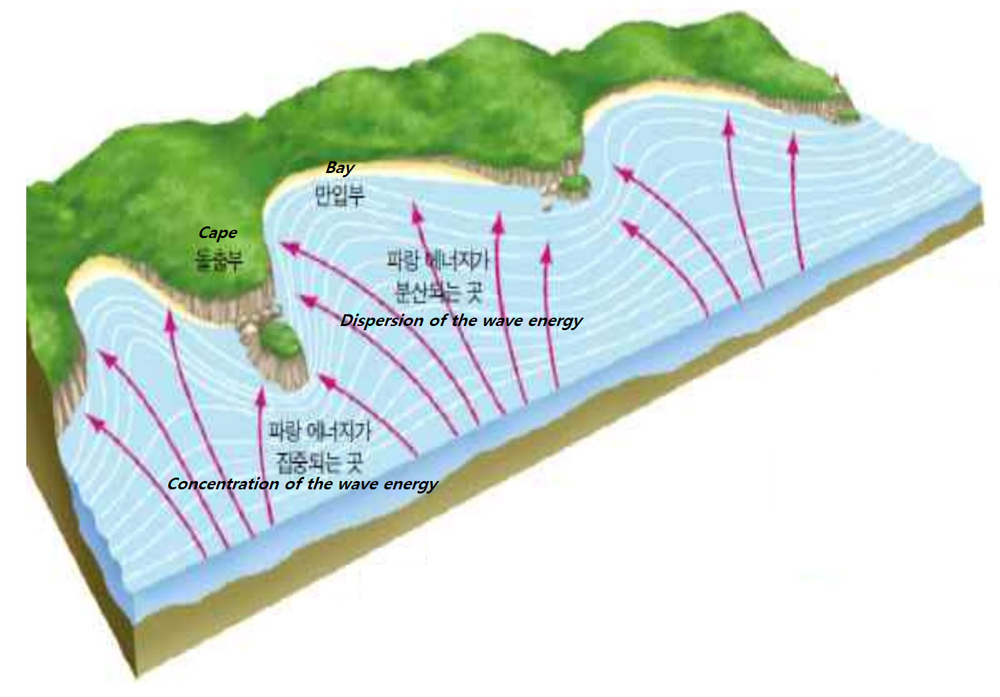
파랑의 전진 속도는 수심이 깊은 만입부보다 수심이 얕은 돌출부 부근에서 먼저 감소하므로 파랑의 굴절이 발생한다. 그 결과 파랑 에너지는 돌출부에서는 집중되고 만입부에서는 분산된다. 따라서 돌출부에서는 침식작용으로 해식절벽이 만들어지고, 만에서는 힘이 약해져 모래가 퇴적되어 백사장이 만들어집니다. 파도의 힘이 강한 해식절벽 아래에서는 가벼운 모래는 쓸려가고 무거운 자갈만이 남아 역빈이 만들어 집니다.
***사진을 클릭하면 크게 볼 수 있습니다.(Click the picture to enlarge!)
Modern Shingle Beach (Stage 3)
Coastal landforms including sea cliffs around the Taejongdae area offer a marvelous view. Between these cliffs, modern shingle beaches with rounded shingles provide a place for people to rest and relax. Pebbles on these beaches are rounded by the continuous actions of the waves.
Velocity of the wave decreases in the vicinity of the shallower cape area than the deeper bay area, so the refraction of the wave occurs. As a result, the wave energy is concentrated in the cape area and dissipated in the bay area. Therefore, a sea cliff is created by erosion in the cape area, sand is deposited to create a sandy beach in the bay area where the strength of the wave is weakened . Below the sea cliff where the power of the waves is strong, light sand is washed away and only heavy shingles remain, creating shingle beach.
[로그하는 법]
- ( )안에 들어갈 숫자는?
- Stage 2의 해식동굴이 만들어지는 과정에서 가장 약한 부분부터 침식이 시작된다. 이 해식동굴의 경우 가장 약한 부분은 어디인가요?
- Stage 3의 자갈마당을 포함하는 태종대 주변은 파랑에너지가 분산되는 곳이다.(진실/오류)
- 캐시존에서 태종대를 배경으로 당신의 GPS(또는 지오캐싱 아이템)를 찍은 사진을 올려주세요.
- 답을 제 Profile에 있는 메시지창을 이용해 제게 보내주세요. 이제 로그하셔도 됩니다. 답에 이상이 있으면 제가 연락드립니다.
[How to log]
- What is the number in ( )?
- At Stage 2 erosion begins from the weakest point of the area. In the case of this sea cave, where is the weakest point?
- Taejongdae area including the shingle beach at Stage 3 is where the wave energy is dissipated (True/False).
- Please upload the photo of your GPS(or any Geocaching item) with Taejongdae in the background!
- Please send the answers to me by message on my profile! You may log as found now. If the answer is not correct, I will contact you.
* 출입제한 시간 : 3월부터 10월까지 - 06:00 ~ 20:00, 11월부터 2월까지 - 07:00 ~ 18:00
* Open : Mar. to Oct. - 06:00 ~ 20:00, Nov. to Feb. : 07:00 ~ 18:00.
Reference : Busan National Geopark
| I have earned GSA's highest level: |
 |