Notice: "Cache seekers assume all risks and responsibilities involved in seeking this earthcache." “Just because it is there, doesn’t mean you have to seek the cache!” Don’t let earthcaching control you, but rather you control earthcaching.
Kloochman Rock
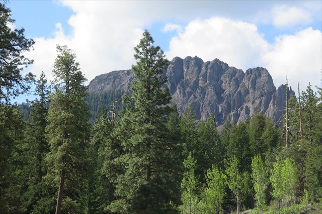
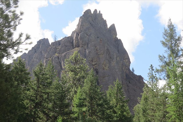
Hidden by Goose Egg Mountain in the Tieton Basin, on the eastern slope of the Cascade Mountain range between Naches and Rim Rock Lake, is a rock formation resembling the dorsal fin of a Spinosaurus dinosaur. The rock formation is called Kloochman which means “wife” in the Chinook language. Legend says a medicine man turn a woman into stone. Geologist classify the formation as a Pillar: Vertical, standing, often spire-shaped, natural rock formation (chimney, monument, pinnacle, pohaku, rock tower). At its highest point, the rock reaches 4,541 feet and a mile long.
Kloochman Rock Formation
Kloochman Rock is an andesite columnar structure, similar to basalt columnar features but made from fine grain high-potassium and calc-alkaline crystal pyroxene. Basalt contains 45-55% silica whereas andesite contains 55-65% silica.
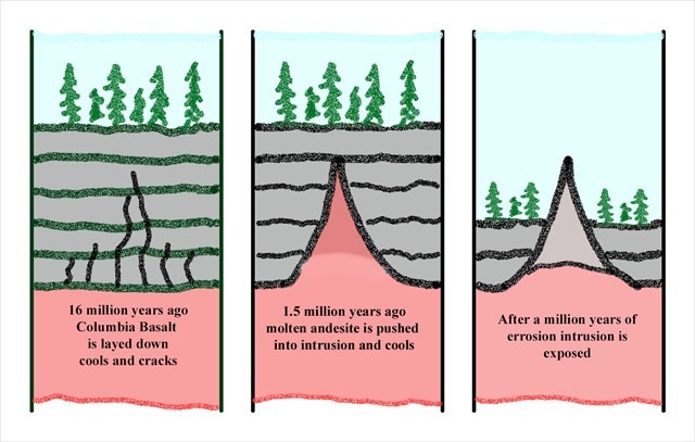
Intrusion
The Kloochman Rock structure was created between 1.39-1.64 million years ago. The Kloochman Rock pillar formation is an exposed example of an “Intrusion”. Columbia River Basalt flowed into the present day Tieton basin during the Miocene epoch 14-17 million years ago. The earth opened up and lava poured out of the ground covering 81,000 square miles to the depth of 2 miles. This basalt layer is called the Columbia River Basalt Group. The basalt would cool and harden. Subsurface voids and cracks were created from tectonic movement in the basalt. These cracks would make their way close to the surface and with the help of magma pressure from the batholith chamber would blow through the surface and create local volcanos such as Rainier, Goat Rocks, and Fifes Peaks. Where subsurface void or crack that did not reach the surface and where magma was under low pressure, andesite would fill these voids, cool and create intrusions. Over millions of years, the surrounding softer basalt around the cooled intrusion eroded away through weather to expose the andesite structure.
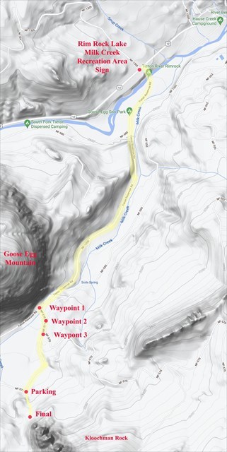
Waypoint and Access Map
Directions
To access Kloochman Rock, turn south off of US 12 onto Tieton Reservoir road. There is a sign on US 12 for Rim Rock Lake and Milk Creek Recreation Area. Stay on Tieton Reservoir paved road to Waypoint 1. Turn left onto NF-570 a dirt road. There is a small red NF-570 sign. Traveling only a short distance stay right onto NF-571 at waypoint 2. Stay left at waypoint 3 and continue on NF-571 to parking area.
Caution
Before hiking to base of Kloochman Rock and the debris field from the parking area, be aware of possible bears, cougars, snakes and ticks in the area. Never hike alone, bring water, wear proper clothing and hiking shoes. The hike is overland with an increase elevation of 100 feet at a distance of under a quarter mile. Leaving the parking area, take the right ridge up the gully to an old logging road. The road will turn into a trail that leads to the base of the formation.
To log this Earthcache,
Please send a private message to me with answers to the following questions.
1. Describe colors and size of the lichens on the andesite blocks within the debris field.
2. Briefly explain how the Kloochman rock intrusion was created?
3. Looking south and up at the north escarpment, what do you believe created the prominent feature that runs from its base to its summit? (tectonics, weathering, earthquakes, or other)
Optional: Upload a photo to the page of local wildlife, unique vegetation or geology in the area.
Kloochman Rock Trailhead
To access the top of the formation, take the Kloochman trail at the southern end of the formation. The trailhead is located off of Lost Lake Road. Take caution for the trail is steep and requires good rock scrambling skills. The trail ends 100 feet below the summit. A high clearances vehicle is recommended to explore this area.
To learn more about the geology of the Tieton Basin read:
Tieton andesite, south-central Washington Cascades: Two of the longest known andesite lava flows by Daryl L. Gusey ; Paul E. Hammond ; John P. Lasher