This cache is one of 31 caches - part of the WGA IAT Series - hidden to highlight Wisconsin's Ice Age Trail. See the bookmark list for all of the geocaches included in this series!
The Wood Lake Segment is wild and remote and highlights scenic Gus Johnson Creek, Wood Lake, wetlands and historic logging camp sites. It is a very remote area that provides welcoming habitat for deer, black bear, wolf, grouse and coyote. Wetlands and lakes are home to eagles, sandhill cranes, loons and beaver. It passes through the Ice Age Trail Alliance's Marimor Preserve and then through Taylor County Forest. It then traverses the scenic and steep-sided valley of Gus Johnson Creek, set between two ice-walled lake plains and formed by gushing from under the ice at the outer edge of the Wood Lake Moraine. This segment has an especially wilderness character to it.
The cache is located at Wood Lake County Park. Park has water, camping, swimming, restrooms and a playground available. More information can be found on page 88 of the Ice Age Trail Guidebook, 2020-2022 edition. This cache can almost be considered a P&G if you know the type of cache camouflage used. Very near the trail. Muscles will be required to reveal the cache. Parking and road into the park are not plowed in winter.
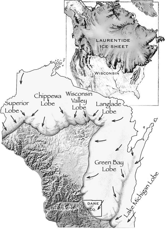
Wisconsin's Last Glacier
Movement of the Laurentide Ice Sheet was shaped—to a certain extent—by the landscape. Highlands diverted the glacier into lobes (tongues or fingers of ice) that advanced into the lowland areas.
The Lake Michigan Lobe of the glacier flowed down the Lake Michigan lowland to central Indiana and Illinois. The Langlade, Wisconsin Valley, Chippewa, and Superior Lobes covered northern Wisconsin. The Green Bay Lobe flowed south in the Green Bay lowland, advancing over the east end of the Baraboo Hills and into both ends of Devils Lake gorge.
The edge of the Green Bay Lobe was probably a steep ice slope, perhaps several hundred feet high, littered with rock debris. Behind the steep slope, the ice surface probably rose very gently toward the center of the ice sheet, where the ice was thousands of feet thick.
The Ice Age National Scenic Trail is one of only 11 national scenic trails in the U.S. It is approximately 1,200 miles long and the entire trail is located within Wisconsin! The trail follows the edge of Wisconsin's most recent glacier and highlights many geological features along the way. The western terminus is located in Interstate State Park in Polk County and continues through a total of 30 counties with the eastern terminus located in Potawatomi State Park in Door County.
WISCONSIN GEOCACHING ASSOCIATION
The Wisconsin Geocaching Association (WGA) is a group of geocachers dedicated to promoting and protecting geocaching within the state of Wisconsin. The WGA organizes geocaching events, works with land owners/managers on geocaching policies, educates the public at large about geocaching, and facilitates communication between WGA members. To learn more about the WGA click on our logo below!
This cache placed by the WGA

|