Hubbard Park is located in Meriden, Connecticut. One of the most popular hiking destinations in the park is Castle Craig, which is located atop East Peak, which is a 976 foot tall mountain in the Hanging Hills, a range of mountainous trap rock ridges that overlook the Quinnipiac River Valley. Probably unknown to many who visit the park, there are some dinosaur tracks near Mirror Lake.
There is a lot of information that we can learn by studying dinosaur tracks. They can tell us whether the dinosaur was walking, trotting, running, or wading. By studying tracks, we can calculate how fast the dinosaur was moving. They can also tell us how the dinosaur carried its tail! In additional to telling us about the dinosaur that made the tracks, tracks can help us learn about the environment where the dinosaurs resided. If there are a bunch of tracks in the same direction, it can indicate a herding or migratory behavior.
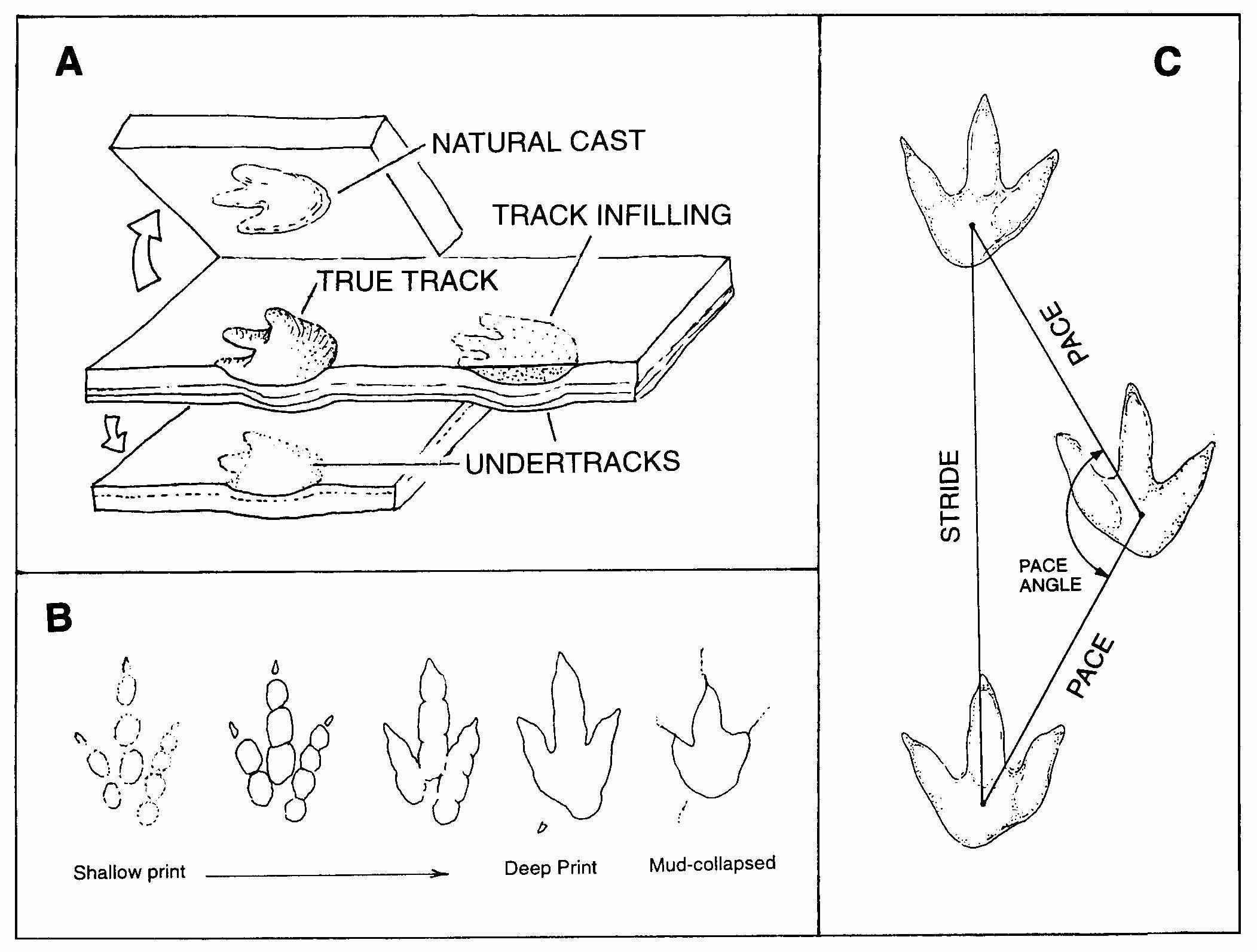
Dinosaur tracks can be found in rocks from the Mesozoic era (252-66 mya) and include the Triassic, Jurassic, and Cretaceous periods. (periods are a subcategory of eras). Unlike fossilized bones, which often are best preserved when they are buried rapidly, tracks are more likely to be well preserved when they are buried in a relatively slow, calm manner. This is why tracks and bones are seldom found in close association. There are two main ways in how tracks are formed and preserved. The most common way is when the dinosaur walks along a moist, but firm, fine grained sediment/soil. The tracks remain exposed for a while and become drier and harder. They then become gently buried with additional sediment, usually of a different type (which allows the layers to separate when later re-exposed). Over the course of millions of years, the original sediment turns into rock. Lastly the tracks become exposed again in modern times by erosion or other forces. The second way in which tracks are formed is when a dinosaur would walk on a very soft surface. The dinosaurs feet might push into other layers of soil below the surface. The soupy surface material might then rush over the depression just made, and in the process cover the prints made in the lower layer. The subsurface prints formed in this case are known as underprints (or undertracks). Since they are buried as soon as they are made, they are not affected by erosion that may be occurring at the surface. The image above provides a visual. It is also worth mentioning natural casts, which like the name suggests are casts of the tracks (think creating a plaster cast of the track, the result would be a mirror image). We can also look at how sediment consistency affects the formation of tracks in the section labeled B on the image. The firmer soils are on the left while the softer ones are on the right, these can affect the quality of the prints.
Logging Requirements:
- Describe the color and texture of the rock containing the dinosaur footprint. Is it fine grained or coarse grained?
- Based on the description (and the image on the cache page), do you think this is a true track, undertrack, or natural cast? What led you to that conclusion?
- Look closely at the track(s), using the image as a guide, which track variation do you think most closely resembles what is found here? What does this tell us about the consistency of the soil at the time the dinosaur walked atop it?
- Upload a photo with the dinosaur tracks or Mirror Lake in the background. You do not need to be in the photo, though it is strongly encouraged.