This cache is one of 31 caches - part of the WGA IAT Series - hidden to highlight Wisconsin's Ice Age Trail. See the bookmark list for all of the geocaches included in this series!
The Sauk Point Segment covers a very quiet corner of Devil's Lake State Park and offers access to spectacular Parfrey's Glen. Hikers will not want to miss beautiful Parfrey's Glen State Natural Area, Wisconsin's first State Natural Area. On this segment, hikers will pass through a mixture of hardwood forest including pockets of red cedar and groves of aspen. Occasional large "wolf trees" surrounded by mostly younger trees, indicate this area was probably used as farmland or open pasture before being allowed to transition back to forest a few decades ago. Continuing west on the trail, hikers will find themselves in Wisconsin's most visited state park, Devil's Lake!
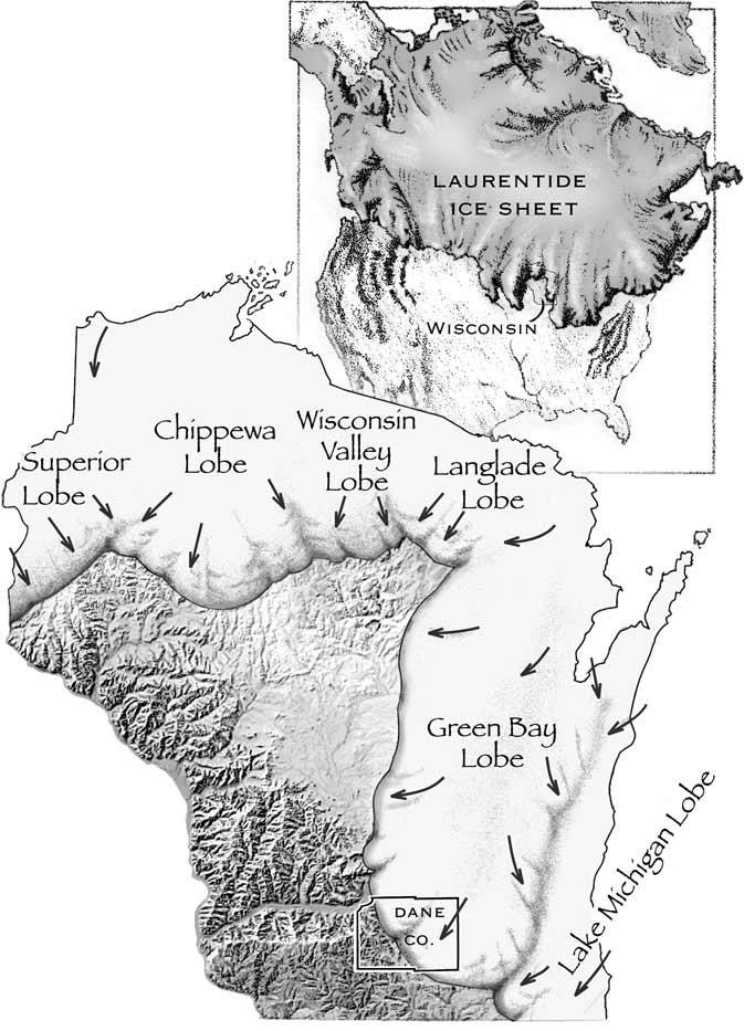
Wisconsin's Last Glacier
Movement of the Laurentide Ice Sheet was shaped—to a certain extent—by the landscape. Highlands diverted the glacier into lobes (tongues or fingers of ice) that advanced into the lowland areas.
The Lake Michigan Lobe of the glacier flowed down the Lake Michigan lowland to central Indiana and Illinois. The Langlade, Wisconsin Valley, Chippewa, and Superior Lobes covered northern Wisconsin. The Green Bay Lobe flowed south in the Green Bay lowland, advancing over the east end of the Baraboo Hills and into both ends of Devils Lake gorge.
The edge of the Green Bay Lobe was probably a steep ice slope, perhaps several hundred feet high, littered with rock debris. Behind the steep slope, the ice surface probably rose very gently toward the center of the ice sheet, where the ice was thousands of feet thick.
The Ice Age National Scenic Trail is one of only 11 national scenic trails in the U.S. It is approximately 1,200 miles long and the entire trail is located within Wisconsin! The trail follows the edge of Wisconsin's most recent glacier and highlights many geological features along the way. The western terminus is located in Interstate State Park in Polk County and continues through a total of 30 counties with the eastern terminus located in Potawatomi State Park in Door County.
WISCONSIN GEOCACHING ASSOCIATION
The Wisconsin Geocaching Association (WGA) is a group of geocachers dedicated to promoting and protecting geocaching within the state of Wisconsin. The WGA organizes geocaching events, works with land owners/managers on geocaching policies, educates the public at large about geocaching, and facilitates communication between WGA members. To learn more about the WGA click on our logo below!
This cache placed by the WGA

|
The Geocache Notification Form has been submitted to the Wisconsin DNR. Geocaches placed on Wisconsin Department of Natural Resources managed lands require permission by means of a notification form. Please print out a paper copy of the notification form, fill in all required information, then submit it to the land manager. The DNR Notification form and land manager information can be obtained at the Wisconsin DNR website.