Schistosité
Feuilletage plus ou moins serré présenté par certaines roches, acquis sous l'influence de contraintes tectoniques, distinct de la stratification, et selon lequel elles peuvent se débiter en lames plus ou moins épaisses et régulières. (Fouc.-Raoult Géol. 1980).
La schistosité décrit une famille de plans sub-parallèles et régulièrement espacés selon lesquels les roches schistosées se débitent (ou se clivent) facilement en feuillets plus ou moins épais. Ces feuillets marquent l'aplatissement de la roche schistosée, en général lors d'une phase de déformation. Le plan de schistosité s'ouvre facilement car il s'agit d'une discontinuité mécanique; cette propriété est mise à profit dans la taille des ardoises et des lauzes, par exemple.
Les plans de schistosité se développent selon une direction perpendiculaire au plan d'aplatissement maximal. Ils concernent uniquement les minéraux qui peuvent être orientés (minéraux ayant une forme d'aiguille, de prisme ou en plaquettes) et reflètent souvent le fait que des micas (foliation) sont réorientés, ont cristallisé ou recristallisé à plat sur ces plans.
Schistosity
More or less tight foliation presented by certain rocks, acquired under the influence of tectonic constraints, distinct from stratification, and according to which they can be cut into more or less thick and regular blades. (Fouc.-Raoult Géol. 1980).
The schistosity describes a family of sub-parallel and regularly spaced planes according to which the schistose rocks are easily cut (or split) into more or less thick layers. These layers mark the flattening of the schistose rock, generally during a deformation phase. The schistosity plane opens easily because it is a mechanical discontinuity; this property is put to good use in the size of slates and lauzes, for example.
The schistosity planes develop in a direction perpendicular to the maximum flattening plane. They relate only to minerals that can be oriented (minerals having a needle, prism, or platelet shape) and often reflect the fact that micas (foliation) are reoriented, crystallized, or recrystallized flat on these planes.
Pendage
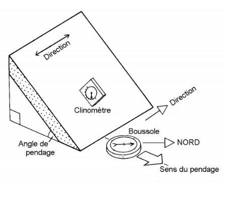
L'angle qui existe entre un plan horizontal et la surface d'une couche, d'un plan de schistosité, d'un contact anormal, etc. est appelé pendage.
On mesure le pendage avec un clinomètre.
Le sens, ou direction du pendage est la plus grande pente orientée vers le bas.
Dip
The angle between a horizontal plane and the surface of a layer, a schistosity plane, an abnormal contact, etc. is called dip.
The dip is measured with a clinometer.
The direction of the dip, is the greatest downward slope.

Questions pour valider cette earthcache :
D'après vos observations et à l'aide du descriptif :
Questions to validate this earthcache :
Based on your observations and using the description :
Question 0
Joindre à votre log (pas à vos réponses) une photo de votre GPS, votre GC perso ou tout autre objet de geocaching aux coordonnées de la cache (sans montrer les réponses !).
Les simples photos de paysage ou capture d'écran de votre position ne permettent de valider cette condition de log.
Cette tâche est obligatoire et autorisée par les guidelines mises à jour en juin 2019.
Attach to your log (not to your answers) a photo of your GPS, your personal GC or any other geocaching object at the posted coordinates (without showing the answers !).
The simple photos of the landscape or screenshot of your position do not validate this log condition.
This task is mandatory and allowed by the guidelines updated in june 2019.
Aux coordonnées, vous pouvez observer de près la schistosité dans un affleurement du talus (à droite du chemin quand le puits est face à vous).
At the coordinates, you can closely observe the schistosity in an outcrop of the embankment (to the right of the path when the well is in front of you).
Question 1
La schistosité peut-elle affecter d'autres roches que les schistes ? Expliquez votre réponse.
Can schistosity affect rocks other than shale ? Explain your answer.
Question 2
Quel type de schistosité peut-on observer ? Schistosité de fracture, foliation diagenétique ou schistosité de flux ?
What type of schistosity can we observe ? Pencil schistosity, diagenetic foliation or slaty schistosity ?
Question 3
Quel est l'angle de pendage du plan de schistosité ?
What is the dip angle of the schistosity plane ?
Envoyez-moi vos propositions de réponses soit via mon profil, soit via la messagerie geocaching.com (Message Center) PUIS loguez cette cache "Found it", je vous contacterai en cas de problème.
Assurez vous de répondre à TOUTES les questions ! La condition principale pour loguer une Earthcache étant de répondre aux questions posées dans le descriptif, tout log "Found it" enregistré sans envoi préalable de vos propositions de réponses sera supprimé. Il en sera de même pour les logs enregistrés sans la photo requise.
Send me your proposals for answers either via my profile or via the geocaching.com messaging (Message Center) THEN log this cache "Found it", I will contact you in case of problem.
Make sure to answer ALL questions ! The main condition to log an Earthcache is to answer the questions asked in the description, any log "Found it" registered without prior submission of your proposals of answers will be deleted. It will be the same for logs saved without the required photo.
