*Submit your answers to a google form with this link. Submitting your answers is REQUIRED and logs without submitted answers will be deleted*
Introduction:
All but unknown today, Coal mining was once the second largest raw material industry in King County. In addition to King County, coal was found and mined in significant quantities in Kittitas, Pierce, Cowlitz, and Whatcom counties.
Coal is fossilized vegetal matter that can be found in several different hardness's. Although it is sometimes regarded as a mineral, it is more properly considered a rock, as it has no definite chemical composition, as a mineral does. Coal can be found in several different grades of hardness, depending on how much temperature and pressure that the plant matter was subjected to.
Coalification:
The process of dead plant matter being transformed into coal, known as coalification, starts with the formation of Peat in Peat Bogs. Sediment then gradually builds up over the peat and begins adding heat and pressure to the peat, eventually transforming it into coal.
Associated rocks:
Because coal is formed in the presence of heat and pressure, as the peat is buried by sediment, the weight of the sediment will also cause sedimentary rocks, such as Sandstone to form from the sediment. If further heat and pressure is applied to the sedimentary rocks, metamorphic rocks such as Slate may also be formed from the sedimentary rocks. As a result of the similar processes that result in the formation of these rocks, and their own role in the formation of coal, these rocks may be found alongside beds of coal.
Coal and geomorphology:
After the formation of the coal seams, alterations to the land, referred to as geomorphology, began to affect the coal bed. The formation of the Cascade mountains and Cascade foothills as a result of the collision of the Pacific and North American plates, which lifted, tilted, and altered coal beds around the region.
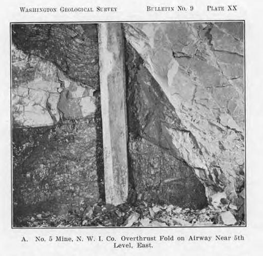
A coal seam in the Roslyn area altered by the thrusting of other rocks into and around the coal seam.
As the coal was lifted, erosion of the surrounding soil and rock by streams as they formed valleys, eventually exposed the coal seams, which would otherwise have been difficult to locate.
Coal Grades:
As the coal was subjected to increasing pressure and heat, the concentration of carbon increased within the coal, forming different grades of coal, beginning with Lignite at 25%–35% carbon, and progressing through Sub-bituminous at 35%–45% carbon, Bituminous at 45%–86% carbon, and ending at Anthracite, the most concentrated percentage of carbon, at 86%–97% carbon. The Newcastle field is Sub-bituminous.
You will be visiting two different coal seams in the Newcastle coal fields. Please make sure you visit BOTH locations, the coordinates for waypoint two is in the additional waypoints section, and credit will NOT be given for partial answers.
Posted coordinates:
1: Look to the north from the coordinates, you should be able to see a seam of coal. Why is this seam visible? (Please explain WHY the seam is visible at the site, NOT WHAT you see of the seam at the site.)
2: Is this seam lying flat, or is it lying at an angle?
3: What process might have left this seam of coal laid in its present position? (Hint, this question is closely related to question #2.)
4: What kind of rock is the coal associated with in this location? (For example, gneiss, slate, limestone, sandstone, basalt, granite)
5: What type of rock is this? metamorphic, sedimentary, or igneous?
6: Why, based on the processes used to form this type of rock and coal, might this type of rock be associated with coal?
Waypoint two:
At waypoint two, you will find more rock that is associated with coal (the seam here doesn't appear to be visible).
7: What kind of rock is coal associated with in this location? (For example, gneiss, slate, limestone, sandstone, basalt, granite)
8: What type of rock is this? metamorphic, sedimentary, or igneous?
9: Why, based on the processes used to form this type of rock and coal, might this type of rock be associated with coal?
*Submit your answers to a google form with this link. Submitting your answers is REQUIRED and logs without submitted answers will be deleted*
(Please note that messages sent to me from Geocaching's message system while in the field, may not receive an immediate response.)
Sources:
Bulletin #3, Washington Geological Survey
The Coal Fields of King County
By George Watkin Evans
Bulletin #9, Washington Geological Survey
The Coal Fields of Kittitas County
By Edwin J. Saunders
Physical Geology
By Robert J. Foster.
Coal explained
U.S. Energy Information Administration
Coal explained
 This cache was placed by a WSGA member. If you are a geocacher in the state of Washington, please consider joining Washington State Geocaching Association. See the WSGA website for details. This cache was placed by a WSGA member. If you are a geocacher in the state of Washington, please consider joining Washington State Geocaching Association. See the WSGA website for details. |