Español
Localización
El río Cares es un corto río de montaña del norte de España, que discurre por la provincia de León y la comunidad autónoma de Asturias y es afluente del río Deva. Forma una espectacular garganta por la que discurre la concurrida ruta del Cares. Cuenta con dos presas (la de la central hidroeléctrica de Camarmeña y la de Poncebos) y es conocido por sus salmones atlánticos, su bella fauna y por ser uno de los más bellos ríos de la península ibérica.
Geomorfologia
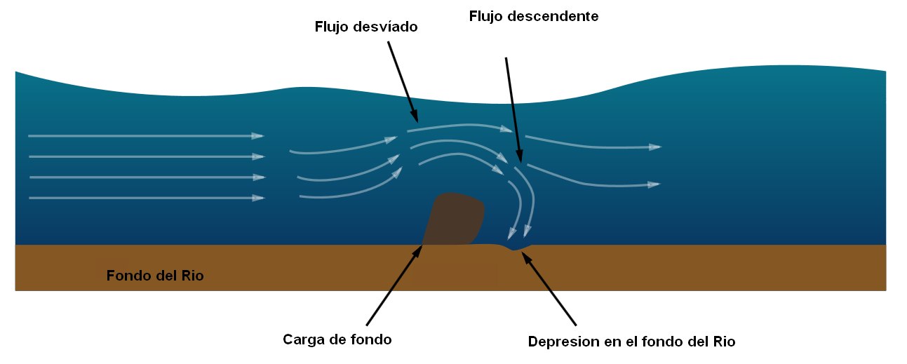
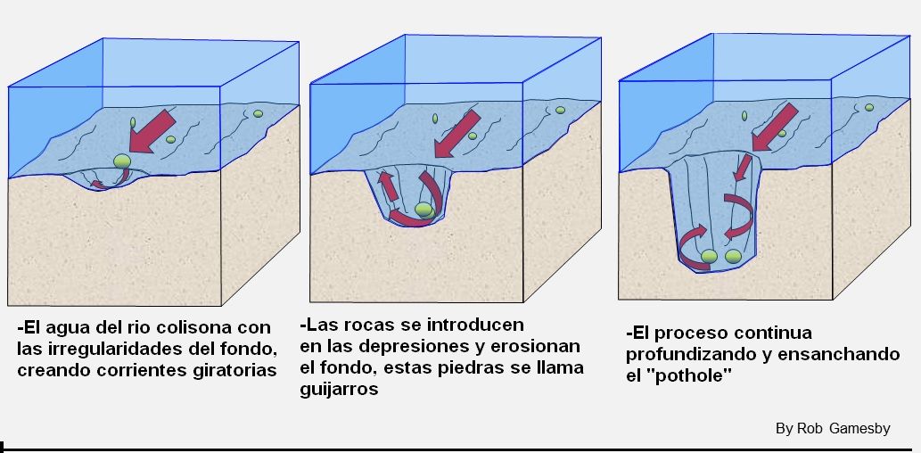
Los "potholes" son agujeros cilíndricos perforados en el lecho de un río que varían en profundidad, diámetro desde unos pocos centímetros hasta varios metros. Se encuentran en el curso superior de un río donde tiene suficiente energía potencial de erosionar verticalmente y su flujo es turbulento. En el curso superior de un río, su carga es grande y se transporta principalmente por tracción a lo largo del lecho del río. Cuando el agua fluye y encuentra de objetos en el fonfo, este es forzado a pasar sobre él y se forman corrientes descendentes detrás de la carga de fondo en remolinos de corrientes cortantes. Estas corrientes erosionan el lecho del río y crean pequeñas depresiones en ella.
A medida que estas depresiones se profundizan, los guijarros pueden quedar atrapados en ellos. Como resultado de las corrientes giratorias, los guijarros comienzan a taladar en las depresiones haciéndolos más circulares, más anchos y más profundos. Los guijarros sólo serán capaces de erosionar el lecho de un río, si la roca de los guijarros esta formada de un material más fuerte que la roca del lecho del río
Para registrar este earthcache, enviame um correoeletrónico com la respuesta a las seguintes preguntas:
1) ¿Cual es el primer origen de los "potholes"? ¿En que parte del rio se suelen formar y porque?
2) Desde el puente podras ver varios ejemplos de pothole, ¿en que lado puedes ver mas? ¿cuantos puedes ver? ( mas de 5 o menos )
3) Indica el tamaño medio de estos potholes
4) Añade una fotografia tuya en el local, u otra en la que se pueda ver algún objeto, o tu nick en un papel
-Si crees que as concluido con exito los objetivos de este Earth Cache, y me ha enviado todas las respuestas solicitadas, puede hacer el log. Luego yo comprobaré que son correctas, y si hay cualquier problema me pondre en contacto para arreglarlo.
-Logs sin respuestas enviadas previamente, seran borrados sin aviso
English.(google translate)
Location
The Cares River is a short mountain river in northern Spain, which runs through the province of León and the autonomous community of Asturias and is a tributary of the Deva River. It forms a spectacular gorge through which the busy Cares route runs. It has two dams (that of the Camarmeña hydroelectric plant and that of Poncebos) and is known for its Atlantic salmon, its beautiful fauna and for being one of the most beautiful rivers in the Iberian Peninsula.
Geomorphology
Potholes are cylindrical holes drilled into the bed of a river that vary in depth, diameter from a few centimetres to several metres. They’re found in the upper course of a river where it has enough potential energy to erode vertically and its flow is turbulent. In the upper course of a river, its load is large and mainly transported by traction along the river bed. When flowing water encounters bedload, it is forced over it and downcuts behind the bedload in swirling eddie currents. These currents erode the river’s bed and create small depressions in it.
As these depressions deepen, pebbles can become trapped in them. As a result of the eddie currents, the pebbles drill into the depressions making them more circular, wider & deeper. Pebbles will only be able to erode a river’s bed though if the rock the pebble’s made of is stronger than the rock the river bed is made of.

To log this earthcache, send me an email /message with the answer to the following questions:
1) What it is the first origin of the potholes? What part of the river are they often formed and why?
2) From the bridge you can see several examples of pothole, on which side can you see more? How many can you see (more than 5 or less)
3) Indicate the average size of these potholes
4) Add a photo of yourself at the place, or another in which you can see an object, or your nick on a piece of paper
-If you believe you have successfully completed this Earth Cache goals and has already sent to me all the requirements as requested, Please, feel free to log it as found. Later i will verify the requirements sent and, if necessary, contact you in order to make the necessary corrections to your log.
-Logs without answers, will be deleted without notice.