


Willkommen auf Biyadhoo Island im Süd Male' Atoll !
Wir verbrachten einen tollen Urlaub auf dieser traumhaften naturbelassenen Malediven Insel.
Das hat mich zu der Idee gebracht hier einen EC für Schwimmer und Schnorchler auszulegen.
Weil diese Insel nicht nur von den anwesenden Gästen sondern wegen dem tollen Hausriff auch
von vielen Ausflugschiffen mit ihren Gästen an Bord angefahren wird.
So hoffe ich hier einen lehrreichen EC anzubieten zu können der Euch Spaß macht.
Hier aber nun einige allgemeine Informationen zu den Inseln im indischen Ozean.
Die Malediven Atolle sind die größten und vielleicht schönsten der Erde. Ihre vielfältigen Blautöne und das kräftige Türkis bilden einen wunderschönen Kontrast zum tiefblauen Indischen Ozean, zu schneeweißen Stränden und kräftig grünen Palmen. Doch wie sind sie entstanden?
Riffentstehung
Eine der ersten Subsidenztheorien (Senkungstheorien) über die Riffentstehung äußerte Charles Darwin (1809 - 1882) in seinem Werk "The Origin of Coral Reefs". Nach dieser Theorie entstehen Atolle aus Saumriffen um eine Vulkaninsel. Diese Saumriffe entwickeln sich zum Barriereriff und schließlich zum Atoll.
Im Laufe der Zeit versinken die Vulkaninseln im Ozean entweder durch Erosion, Absinken des Meeresbodens oder Ansteigen des Meeresspiegels. Dadurch wächst das Korallenriff an die Oberfläche und verändert sich wie folgt:
Bleibt die Insel unverändert, wächst das Korallenriff nach außen.
Steigt die Insel, wächst das Korallenriff auch nach außen. Die inneren Bereiche werden über das Wasser gehoben und bilden Riffterrassen.
Sinkt die Insel, dann entwickelt sich ein Barriereriff, dass durch eine immer tiefer werdende Lagune vom Inselfestland getrennt wird.
"Diese Inseln sind wie ein Organismus, der wächst, sich ständig verändert und manchmal auch vergeht." (Neuseeländischer Geomorphologe Kench)
Der Wissensstand über die Dynamik der Koralleninseln ist heute sehr gering.
Malediveninseln
Die Malediveninseln wachsen durch die Existenz und das Sterben der Steinkorallen. Diese siedeln sich auf unterseeischen Bergstümpfen, den Überresten versunkener Vulkane, an.
Reste verwitterter Pflanzen, Korallensand und -kalk sowie Exkremente von Papageienfischen bilden das Baumaterial der Atolle und rundherum ein Riff, das kontinuierlich emporwächst, bis es an einigen Stellen aus dem Wasser ragt.
Stürme, Wellen und Strömungen sind die Bauhelfer. Sie türmen Sedimente der Korallengärten, Exkremente der Fische und Pflanzenteile zu Stränden und Inseln auf. Während des letzten großen Tsunami wuchsen die Inseln bis zu 30 Zentimeter in die Höhe.
Der Meeresspiegel darf nicht mehr als 10 Millimeter pro Jahr ansteigen oder absinken. Dies entspricht der Geschwindigkeit, mit der die Korallen unter optimalen Wassertemperaturen wachsen.
Erhöht sich zum Beispiel die Ozeantemperatur um 4 Grad Celsius, zerfallen die Steinkorallen. 1998 war zum Beispiel ein besonders warmes Jahr. Die Temperaturen im Indischen Ozean waren höher als in anderen Jahren, was zur kompletten Zerstörung vieler Riffe führte.
Inwieweit neue und angepasste Korallen sich so schnell ansiedeln können, ist heute unklar. Auf jeden Fall wurden bereits Korallen entdeckt, die sonst nur im Persischen Golf bei 10 Grad höheren Temperaturen vorkommen.
Malediven Atoll Entstehung
Darwins Theorie wurde 1951 durch Bohrungen im Eniwetok-Atoll bestätigt. In etwa 1.300 Meter Tiefe stieß der Bohrer auf Basalt vulkanischen Ursprungs.
Innerhalb von Millionen Jahren versank langsam Land. Darauf wuchs das Riff in den letzten 4.000 bis 5.000 Jahren in Richtung Licht, bis es das vollständig versunkene Land überzog und schließlich ein kreisrundes Atoll um eine halbgeschlossene Lagune bildete.
Urkontinent Gondwana
Vor etwa 200 Millionen Jahren zerfiel der Urkontinent Gondwana im Indischen Ozean, und das Land driftete auseinander. Übrig blieben vier mittelozeanische Meerrücken von ungefähr 2.000 Kilometern Länge. Die Gipfel der Vulkane ragten aus dem bereits tropisch warmen Meer heraus, die Korallen bauten die ersten Saumriffe und schließlich riesige Bänke, wie sie noch heute im Bereich des maledivischen Rückens existieren.
Maledivischer Rücken
Der Indische Ozean weist in 3.000 bis 5.000 Metern Tiefe Unterseegebirge auf. Die Malediven befinden sich auf einem dieser Gebirge. Der Maledivische Rücken wird als Lakkadiven-Chagos-Rücken bezeichnet, da er sich von den Lakkadiven Inseln zum Chagos Archipel hinzieht. Die höchsten Punkte dieses Rückens befinden sich heute circa 2.200 bis 2.400 Meter unter dem Meeresspiegel. Der Maledivische Rücken ist 2.500 Kilometer lang, 170 Kilometer in Nord-Süd-Richtung breit und bildet eine Riesenlagune, die Inner Sea. Diese ist nur zwischen 350 und 900 Meter tief. Die Kanäle von der Lagune zum Ozean erreichen 1.400 Meter Tiefen.
Malediven Atoll Anordnung
Ein Malediven Atoll weist oft eine ringförmige Anordnung auf, was auf die vulkanische Vorgeschichte deutet.
Der Atollhang oder untere Riffhang bildet die Grenze zum Ozean. Hier fällt das Riff ab 18 bis 20 Metern Tiefe steil zum Ozeanboden ab. Bis zu 40 Metern Tiefe befinden sich Steinkorallen, ab etwa 40 Metern Tiefe treten Weich- und Lederkorallen auf. Steinkorallen und koralline Algen sind die eigentlichen "Riffbauer".
Oberer Riffhang (Wellenbrecher), seewärtige Riffkante und äußeres Riffwatt bilden den Atollrand. Der Bereich des Außenriffs ist für Taucher am interessantesten. Hier findet sich die größte Artenvielfalt.
Auf den Riffdächern liegen 1.192 Inseln und viele Sandbänke in runder, ovaler oder sichelförmiger Form. Sie ragen nur weniger Meter aus dem Meer auf. Sie bestehen aus Schutt, Sanden und Geröll von Korallenkalk.
Salztolerante Pionierpflanzen siedeln sich zuerst an, schützen die Inseln vor Sturm und Wellen und akkumulieren mehr Sand. Die kleinsten Inseln sind circa 0,5 Quadratkilomter, die größte 5,2 Quadratkilomter groß.
Entstehungszeit eines Korallenriffs
Ein Korallenriff benötigt eine lange Zeit zur Entstehung. Das älteste Riff ist fast 50 Millionen Jahre alt.
Koralleninsel
Vor circa 15.000 Jahren eroberten Pflanzen, Tiere und Menschen die neu entstandenen Inseln im Meer, um sie heute wieder langsam an das Meer zu verlieren. Viele bewohnte Koralleninseln sind bereits wieder im Meer versunken, Menschen mussten umgesiedelt werden. Die Malediven Regierung verhandelt heute über Landkäufe in Afrika, um alle Menschen umzusiedeln, sollten die Malediven abermals im Ozean versinken.
Atollring
Große Atollringe besitzen Kandus oder Rifföffnungen, die meist durch die Natur geschaffen wurden. Der Mensch greift oft ein und verbreitert oder legt künstliche Rifföffnungen an, die markiert werden. Leider verändern sich dadurch die Strömungsverhältnisse in den Lagunen.
EURE AUFGABE ZUM CACHE:
1.) Die Insel wächst durch die Existenz & das Sterben der Steinkorallen, und sogar durch die Exkremente von Fschen.
- Was ist aber die Grundlage, bzw. Ursprung auf die die Atolle stehen ?
2.) Wenn ihr hier an dieser Stelle ins Wasser geht und zur Riffkante schwimmt merkt ihr eine unsichtbare Grenze von 2 Bereichen.
- Welche zwei unterschiedliche Bereiche sind das?
A.) Temperatur + Farbe vom Riff
B.) Farbe vom Riff + Salzgehalt im Wasser
C.) Strömungsrichtung + Salzgehalt im Wasser
D.) Farbe vom Riff + Strömungsrichtung
E.) Strömungsrichtung + Temperatur
3.) Erkläre mir mit deinen Worten warum dieses so ist ?
4.) An der sudlichsten Stelle der Insel bebindet sich etwas besonderes was man hier auf so einer kleinen Insel nicht erwartet.
- Was ist das ?
5.) Erstelle für den Log ein Logfoto
Logfoto 1
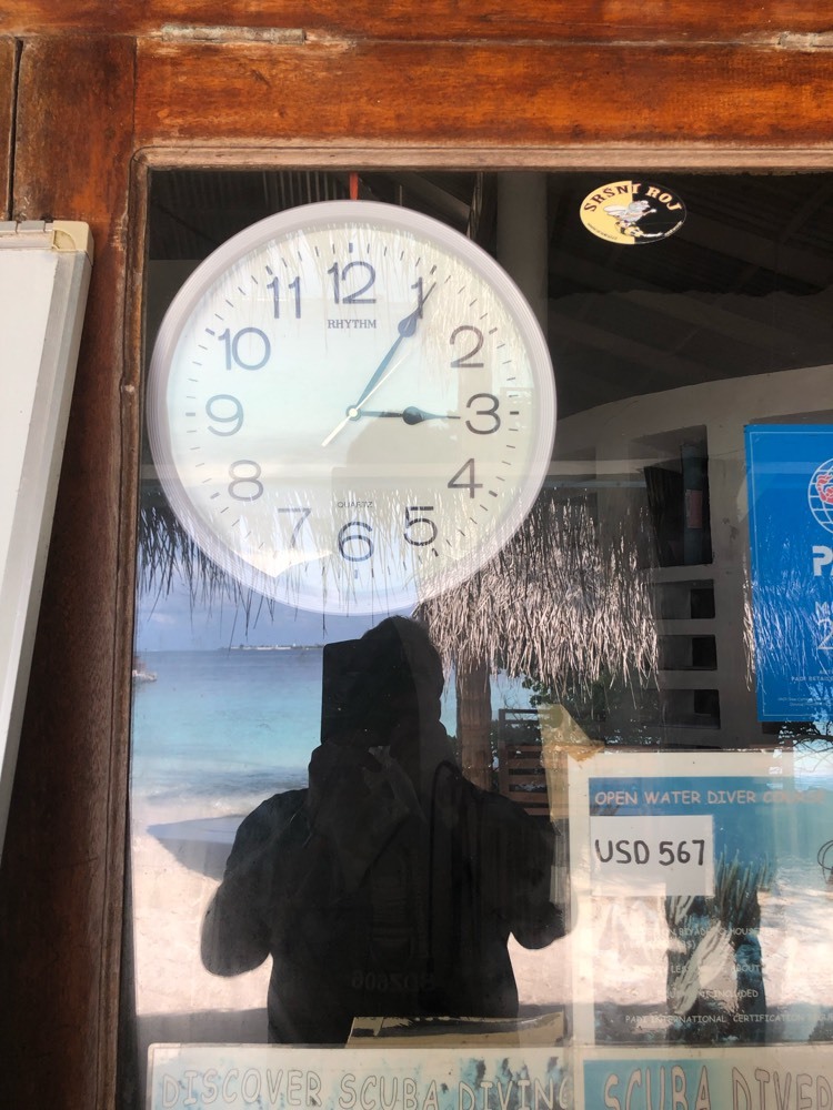
Euch vor dem Fester an der Tauchschule, oder mit dir auf einem Boot mit der Insel im Hintergrund !

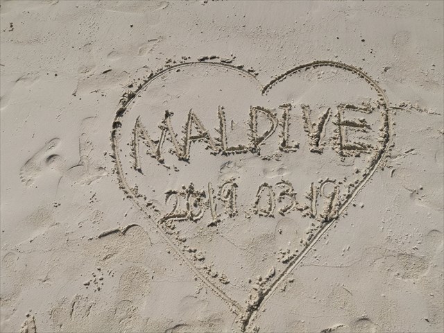
Logfoto 2 ( optional ) - Ein Herz im Sand mit Datum
Ich wünsche euch viel Spaß bei diesem EC und einen schöne Zeit auf dieser tollen Insel.
Schickt mir Eure vier Antworten und stellt das Logfoto mit ein.
Dann dürft ihr sofort loggen, sollten die Antworten nicht stimmen werde ich mich bei Euch melden.
Sollte ich keine Antworten erhalten oder ein Logfoto fehlt, werde ich leider das log löschen müssen.
.........................

Welcome to Biyadhoo Island in the South Male' Atoll !
We spent a great vacation on this beautiful natural Maldives island.
This gave me the idea to create an Earth Cache for swimmers and snorkelers here.
Since this island is visited not only by the guests present, but also by many excursion ships with
their guests on board because of the great house reef.
So I hope to be able to offer here an instructive EC which is fun for you.
But here is some general information about the islands in the Indian Ocean.
The Maldives atolls are the largest and perhaps the most beautiful on earth. Their varied shades of blue and vibrant turquoise contrast beautifully with the deep blue Indian Ocean, snow-white beaches and vibrant green palm trees. But how did they form?
Reef formation
One of the first subsidence theories about reef formation was expressed by Charles Darwin (1809 - 1882) in his work "The Origin of Coral Reefs". According to this theory, atolls develop from fringing reefs around a volcanic island. These fringing reefs develop into barrier reefs and finally into atolls.
Over time, the volcanic islands sink into the ocean either through erosion, subsidence of the seafloor, or rising sea levels. As a result, the coral reef grows to the surface and changes as follows:
If the island remains unchanged, the coral reef grows outward.
If the island rises, the coral reef also grows outward. The inner areas are lifted above the water and form reef terraces.
If the island sinks, then a barrier reef develops, separated from the island mainland by an ever-deepening lagoon.
"These islands are like an organism that grows, constantly changes, and sometimes perishes." (New Zealand geomorphologist Kench)
The level of knowledge about the dynamics of coral islands today is very low.
Maldives Islands
The Maldives Islands grow due to the existence and death of stony corals. These settle on submarine snags, the remains of submerged volcanoes.
Remains of weathered plants, coral sand and limestone, and excrement of parrot fish form the building material of the atolls and all around a reef that grows up continuously until it protrudes from the water in some places.
Storms, waves and currents are the building helpers. They pile up sediments of the coral gardens, excrements of the fish and plant parts to beaches and islands. During the last big tsunami, the islands grew up to 30 centimeters in height.
Sea levels are not allowed to rise or fall more than 10 millimeters per year. This corresponds to the rate at which corals grow under optimal water temperatures.
For example, if the ocean temperature increases by 4 degrees Celsius, the stony corals decay. For example, 1998 was a particularly warm year. Temperatures in the Indian Ocean were higher than in other years, resulting in the complete destruction of many reefs.
To what extent new and adapted corals can settle so quickly is unclear today. In any case, corals have already been discovered that otherwise only occur in the Persian Gulf at temperatures 10 degrees higher.
Maldives Atoll Origin
Darwin's theory was confirmed in 1951 by drilling in Eniwetok Atoll. At a depth of about 1,300 meters, the driller encountered basalt of volcanic origin.
Within millions of years, land slowly sank. Thereupon, over the last 4,000 to 5,000 years, the reef grew toward the light until it covered the completely submerged land, eventually forming a circular atoll around a semi-enclosed lagoon.
Primeval continent Gondwana
About 200 million years ago, the primeval continent Gondwana in the Indian Ocean disintegrated and the land drifted apart. What remained were four mid-ocean ridges about 2,000 kilometers long. The peaks of the volcanoes rose out of the already tropically warm sea, the corals built the first fringing reefs and finally huge banks, as they still exist today in the area of the Maldivian Ridge.
Maldivian Ridge
The Indian Ocean has submarine mountains at depths of 3,000 to 5,000 meters. The Maldives is located on one of these mountains. The Maldivian Ridge is called the Lakkadives-Chagos Ridge because it extends from the Lakkadives Islands to the Chagos Archipelago. The highest points of this ridge today are approximately 2,200 to 2,400 meters below sea level. The Maldivian Ridge is 2,500 kilometers long, 170 kilometers wide in a north-south direction and forms a giant lagoon, the Inner Sea. This is only between 350 and 900 meters deep. The channels from the lagoon to the ocean reach 1,400 meters in depth.
Maldives Atoll Layout
A Maldives atoll often has a ring-shaped arrangement, indicating volcanic prehistory.
The atoll slope or lower reef slope forms the boundary to the ocean. Here the reef drops steeply to the ocean floor from 18 to 20 meters depth. Stony corals are found up to 40 meters depth, soft and leather corals appear from about 40 meters depth. Stony corals and coralline algae are the actual "reef builders".
Upper reef slope (breakwater), seaward reef edge and outer reef mudflats form the atoll edge. The outer reef area is the most interesting for divers. This is where the greatest diversity of species can be found.
On the reef tops are 1,192 islands and many sandbars in round, oval or crescent shapes. They rise only a few meters from the sea. They are composed of rubble, sands, and detritus of coral limestone.
Salt-tolerant pioneer plants settle first, protecting the islands from storms and waves and accumulating more sand. The smallest islands are about 0.5 square kilometers, the largest 5.2 square kilometers.
Formation time of a coral reef
A coral reef takes a long time to form. The oldest reef is almost 50 million years old.
Coral island
About 15,000 years ago, plants, animals and humans conquered the newly formed islands in the sea, only to slowly lose them to the sea again today. Many inhabited coral islands have already sunk back into the sea, people had to be resettled. The Maldives government is negotiating land purchases in Africa today to resettle all the people should the Maldives sink into the ocean again.
Atoll Ring
Large atoll rings have kandus or reef openings, usually created by nature. Man often intervenes and widens or creates artificial reef openings that are marked. Unfortunately, this changes the current conditions in the lagoons.
YOUR TASK FOR THE CACHE:
1.) The island grows through the existence & death of stony corals, and even through the excrement of fish.
- But what is the basis or origin of the atolls?
2.) If you enter the water at this point and swim to the edge of the reef you will notice an invisible boundary of 2 areas.
- What are the two different areas?
A.) Temperature + colour of the reef
B.) Colour of the reef + salinity in the water
C.) Direction of flow + salinity in the water
D.) Colour of reef + direction of current
E.) Direction of flow + temperature
3.) Explain to me in your own words why this is so?
4.) At the southernmost point of the island there is something special that you would not expect to find on such a small island.
- What is it ?
5.) Create a photos for the log
Log photo 1
You in front of the window at the diving school , or on a boat with the island in the background !
Log photo 2 ( OPTIONAL) - A heart in the sand with the date
I wish you a lot of fun with this EC and a nice time on this great island.
Send me your four answers and include the log photo.
Then you may log immediately, if the answers are not correct I will contact you.
If I do not receive any answers or the log photo is missing, I will have to delete your logs.
Wer möchte kann das Banner in sein Profil einbauen.
Whoever wants to can add the banners to their own profile.
Füge dazu einfach folgenden Code in Dein Profil ein: / Just add the following code to your profile:
<a href="http://coord.info/GC9GCMF" target="_blank"><img src="hhttps://s3.amazonaws.com/gs-geo-images/0f01934e-9537-4f6d-89c6-f27f14e47bbd_l.jpg?rnd=0.7346961" border="0" /></a>
Für die ersten drei Finder gibt es eine kleine Tabelle! / For the first three finders there is a small table!
1.) SearchOff
2.) choupinette83
3.) Cerwos
