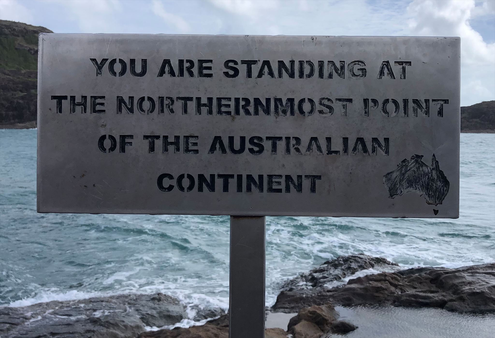
According to the sign at the listed coordinates, “You are standing at the northernmost point of the Australian continent”. But are you?
This earth science lesson is about the formation and movement of the continents.
What are continents?
Continents are the seven main areas of land that make up most - but not all - of the Earth’s surface. They are Asia, Africa, North America, South America, Antarctica, Europe, and Australia. When geographers identify a continent, they usually include all the islands associated with it.
Coastlines do not indicate the actual boundaries of the continents. Continents are defined by their continental shelves. A continental shelf is the edge of a continent that lies under the ocean. Even though they are underwater, continental shelves are part of the continent. The actual boundary of a continent is not its coastline, but the edge of the continental shelf.
Plate tectonics and continental drift
Plate tectonics is a scientific theory that explains how major geological landforms are created and why the continents are moving. It incorporates the theory of continental drift.
In plate tectonics, the Earth’s outermost layer - made up of the crust and upper mantle - is broken into large rocky plates. These plates lie on top of a partially molten layer of rock and move relative to each other at different rates, from two to 15 centimeters per year.
As the plates are pushed together (a “convergent” boundary), they can be pushed up to form mountains, or one may slide under the other to form a deep trench. Where the plates are moving away from one another (a “divergent” boundary), magma escapes into he space to form mountain ridges. When two plates slide past each other (a “transform” boundary), that can give rise to major faults.
A single tectonic plate can have multiple types of plate boundaries with the other plates that surround it. For example, the Pacific Plate, one of Earth’s largest tectonic plates, includes convergent, divergent, and transform plate boundaries.
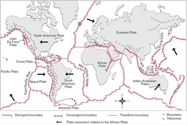
The above simplified diagram of the Earth's tectonic plates and continents shows that, relative to the African Plate, the Indian-Australian Plate is moving broadly north-east, the Eurasian Plate is moving south-east, and the South and North American Plates are generally moving to the west.
To log this earthcache...
To log this earthcache you will need to visit the area after the cache publication date. This will require a walk to the sign at the listed coordinates and to the brass topograph at the Reference Point.
Please send me a message or email addressing each of the following questions and tasks:
- At the listed coordinates, have a look around you, particularly to the north. Based on your observations and the information provided, do you think that you are standing at the northernmost point of the Australian continent? Explain your reasoning.
- At the Reference Point, using the information on the topograph and the information provided above:
(a) What is the location listed as being 11,800 Km away? Which plate is it on? Do you think it is getting closer or further away from where you are standing?
(b) How far away is New York? Which plate is it on? Do you think it is moving closer or further away from where you are standing?
- Take of photo of yourself OR a personal item such as your GPS to show a view of GZ and either include it in the message/email to me with your answers or post it in your log.
Please feel free to log your visit as soon as you have submitted your answers to me. I will respond confirming permission to log, or seeking clarification if I feel that you have not answered the questions correctly. Logs with no answers sent will be deleted. Please do not post your answers or spoiler photographs in your log.
Note that this earthcache requires a 1.5 Km return walk a that is rocky, steep and uneven in places. Please ensure that you are properly prepared and take sufficient drinking water with you.