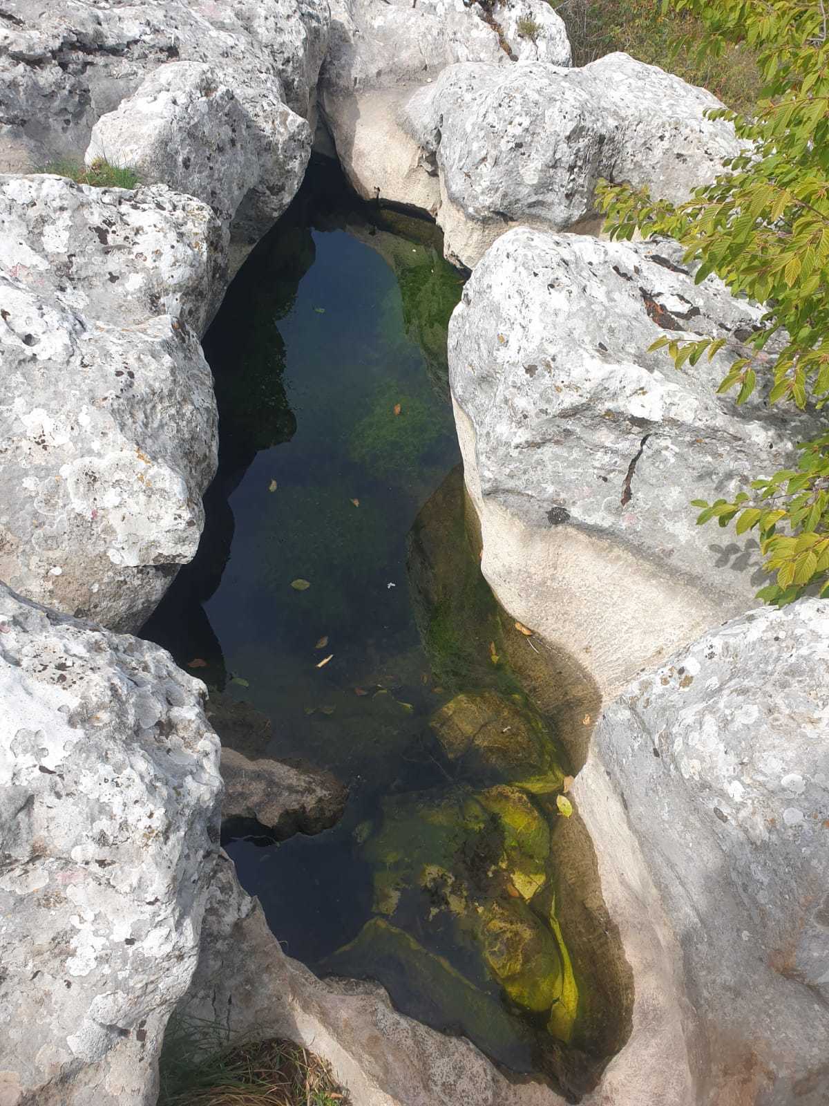
Kamenice su, kao i škrape, vrlo mladi oblici površinskog krškog reljefa. Predstavljaju udubine u vapnencu, koje nastaju na mjestima gdje se zbog blažeg nagiba, kišnica i snijeg duže zadržavaju te postupno polako otapaju vapnenac. Zimi, razaranju vapnenca znatno doprinesli i smrzavanje vode. Na dnu kamenica taloži se netopivi ostatak vapnenca te prašina donesena vjetrim i sisama koji s vremenom mogu stvoriti tanki sloj tla.
Kamenice mogu biti različitih oblika; okrugle, izdužene ili nepravilne, cesto s izrazito ravnim dnom. Najčešće su veličine od samo nekoliko centimetara pa do jednog metra u promjeru, no mogu biti i veće. Produbljivanjem, kamenice postaju zamke za različite sjemenke iz kojih niću trave i druge biljke. Ispunjene vodom kamenice su cesto kolijevka ličinkama vodozemaca, najčešće žaba i pjegavog daždevnjaka te vodenjaka. Voda na površini Biokovo prava je rijetkost i od izuzetne je vrijednosti kako za biljni i životinjski svijet, tako i za ljude. Stoga su veće prirodne kamenice korištene za napajanje stoke, a manje su ljudi ponekad produbljivali i proširivali klesanjem ne bi li zadržale vise vode.
Korozija otopine na stranama konstrukcija obično se javlja većom brzinom nego prema dolje. Ograničena okomita brzina otapanja objašnjava se netopivim ostacima poput kamenog brašna, prašine koju raznosi vjetar i organskih spojeva koji su se nakupili na dnu zdjela.
Znanstvena mjerenja za utvrđivanje starosti divokoza su pokazala slijeganje tla od 0,02 do 0,03 mm / godišnje. To znači da je potrebno 1670 do 2500 godina da se formira Kamenica duboka 5 cm.
Da biste riješili ovu earth cache, odgovorite na sljedeća pitanja i pošaljite mi odgovore putem GC Messengera. Nakon što su odgovori poslani, možete se odmah prijaviti. Javit ću vam se ako nešto bude nejasno ili netočno.
Koliko je visok vodostaj u Kamenici? Koliko bi mogao biti visok dok se ne prelije?
Osvrnite se oko sebe, vidite li još neke manje Kamenice u neposrednoj blizini? Ako je tako, koliko su velike?
Zašto mislite da je ovo bilo idealno mjesto za formiranje jedne (ili više) Kamenica
Fotografirajte sebe, svoju ruku ili osobni predmet ispred Kamenice i postavite je u svoj dnevnik nalaza.
The educational geological trail where the Kamenitza can be found starts on the 9th mile of Biokovo Road between the plateaus. The path is easy to walk and has signposts on the stones. A walking time of about 20 minutes to the earth cache should be planned.
Kamenitzas are also, like karren, very juvenile forms of surface karst relic. They are depressions in limestone rocks wich develop in places where due to the gentle dip, the rain and the snow hold longer and slowly dissolve limestone. In winter time, limestone disintegration is increased due to freezing process. Undissolved residue of limestone is deposited on the bottom of kamenitza together with dust brought by wind and rain. The can gradually form o thin soil layer in a longer time period.
Kamenitzas can develop in various forms: rounded, elongated or irregular, commonly with flat bottom. They are usually just a few centimeters to 1 meter in diameter, but can be even larger.
Kametnitzas often become traps for various seeds, so grass or other plants start growing. Filled by water, they become a candle for larvae of amphibia, usually frogs, toads, fire salamanders and newts. Water on the surface of Biokovo is really rare, Therefore, larger kamenitzas are suitable for watering of cattle. People often deepened smaller ones by carving so they could hold more water.
Solution corrosion on the sides of the structures usually occurs at a faster rate than it does downward. The limited vertical dissolution speed is explained by the insoluble residues such as rock flour, dust blown by the wind and organic compounds that have accumulated on the bottom of the bowls.
Scientific measurements to determine the age of chamois neats showed a subsidence of the soil of 0.02 to 0.03 mm / year. This means that it takes 1670 to 2500 years to form a 5 cm deep Kamenitza
The earth cache:
To solve this earth cache, answer the following questions and send me the answers via GC Messenger. After the answers have been sent, you can log on straight away. I will get in touch with you if anything is unclear or incorrect.
1.) How long and wide do you estimate the Kamenitza?
2.) How high is the water level in the Kamenitza? How high could it be until it overflows?
3.) Have a look around, can you see any other smaller Kamenitzas in the immediate vicinity? If so, how big are they?
4.) Why do you think this was an ideal place to form one (or more) Kamenitza?
5.) Take a photo of yourself, your hand or a personal item in front of the Kamenitza and upload it to your find log.
Der geologische Lehrpfad, wo die Kamenitza zu finden ist, beginnt an der 9. Meile der Biokovo-Straße zwischen den Hochebenen. Der Weg ist einfach zu gehen und mit Wegweisern an den Steinen versehen. Es ist eine Gehzeit von etwa 20 Minuten zum Earthcache einzuplanen.
Kamenitzas sind auch, wie Karren, sehr jugendliche Formen von Oberflächenkarstrelikten. Es handelt sich um Vertiefungen in Kalksteinfelsen, die an Stellen entstehen, an denen durch das sanfte Eintauchen der Regen und der Schnee länger halten und Kalkstein langsam auflösen. Im Winter wird der Kalksteinabbau durch den Gefrierprozess verstärkt. Ungelöste Kalkrückstände lagern sich zusammen mit dem durch Wind und Regen gebrachten Staub auf dem Boden der Kamenitza ab. Sie können über einen längeren Zeitraum allmählich eine dünne Bodenschicht bilden.
Kamenitzas können sich in verschiedenen Formen entwickeln: abgerundet, länglich oder unregelmäßig, gewöhnlich mit flachem Boden. Sie haben meist nur einen Durchmesser von wenigen Zentimetern bis 1 Meter, können aber auch noch größer sein.
Kametnitzas werden oft zu Fallen für verschiedene Samen, so dass Gras oder andere Pflanzen wachsen. Mit Wasser gefüllt, werden sie zu einer Kerze für Amphibienlarven, meist Frösche, Kröten, Feuersalamander und Molche. Wasser auf der Oberfläche von Biokovo ist wirklich selten, daher eignen sich größere Kamenitzas zum Tränken von Rindern. Die Leute vertieften oft kleinere durch Schnitzen, damit sie mehr Wasser aufnehmen konnten.
Die Lösungskorrosion an den Seiten der Strukturen erfolgt normalerweise mit einer höheren Geschwindigkeit als zur Tiefe hin. Die in der Vertikalen eingeschränkte Lösungsgeschwindigkeit erklärt sich durch die am Boden der Näpfe angesammelten unlöslichen Rückstände wie Gesteinsmehl, durch Wind angewehten Staub und organische Verbindungen.
Wissenschaftliche Messungen zur Bestimmung des Alters von Kamenitzen Ergaben eine Absenkung des Bodens von 0,02 bis 0,03 mm/Jahr. Daraus ergibt sich - zur Bildung einer 5 cm tiefen Kamenitza vergehen 1670 bis 2500 Jahre.
Der Earthcache:
Um diesen Earthcache zu lösen, beantworte folgende Fragen und sende mir die Antworten per GC-Messenger zu. Nach dem Zusenden der Antworten kann gleich geloggt werden. Bei Unklarheiten oder falschen Antworten werde ich mich bei dir melden.
1.) Wie lang und breit schätzt du die Kamenitza?
2.) Wie hoch ist der Wasserstand in der Kamenitza? Wie hoch könnte er maximal sein, bis zum überlaufen?
3.) Sieh dich in der Umgebung um, kannst du in der direkten Umgebung noch weitere kleinere Kamenitzas erkennen? Wenn ja, wie groß sind diese?
4.) Warum denkst du, war genau hier ein idealer Ort, zur Bildung einer (oder mehrere) Kamenitza?
5.) Mache ein Foto von dir, deiner Hand oder einem persönlichen Gegenstand vor der Kamenitza und lade es zu deinem Fund-Log hoch.
Quellen:
Informationstafeln
Bild: RauGeo
www.wikipedia.org