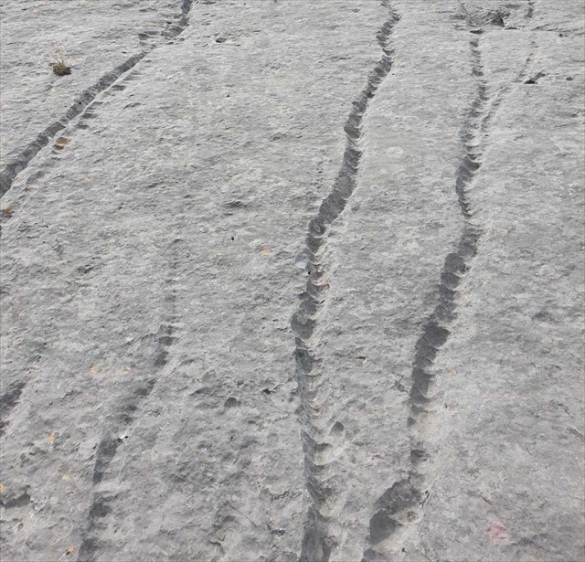
škrape s utorima razvijaju se na izloženim, nagnutim stijenama bez pukotina zbog aktivnosti otapanja kišnice koja otječe. Ovi žljebovi imaju širinu od nekoliko centimetara i idu paralelno jedan s drugim u smjeru nagiba.
Širina se obično održava ravnomjerno po cijeloj dužini. To ih razlikuje od jaruga, koji se sve širi niz padinu i također zarivaju dublje u stijenu. Također imaju nepravilan, blago zavojit tok. Ova dva oblika škrape sežu do korozije ispiranja kontrolirane otopinom gravitacijski ispuštene vode na površini stijene.
Praznina škrape
Pukotine koje se šire po stijenskoj površini postaju smjernice za tekuću vodu i istovremeno predstavljaju infiltracijske putove procjeđivanja.
Izrada Škrape
Počevši od ravnih užlijebljenih škrape, otapanjem na površini vapnenca nastaju uski pukotine. Oni osjećaju praznine. Uzastopno napredujuće rješenje osigurava da se praznine i dalje povećavaju prema načelu samoojačavanja kroz sve veće površine napada. U tim pukotinama skuplja se vremenski materijal koji zbog trajne vlage dodatno uništava stijenu.
Vapnenac se konačno razbija u škrape s oštrim rubovima koja mogu biti duboka nekoliko metara. U daljnjem tijeku, trošenje može otapanjem sniziti polja kolobara, pri čemu netopivi ostaci trošenja tvore područje iz kojeg vire samo pojedini dijelovi još neistrošenog vapna.
Quelle: https://geohilfe.de/
The earth cache:
Da biste riješili ovaj zemaljski cache, odgovorite na sljedeća pitanja i pošaljite mi odgovore putem GC Messengera. Nakon što su odgovori poslani, možete se odmah prijaviti. Ako je nešto nejasno ili netočno, kontaktirat ću vas.
1.) Na ovoj stijeni mogu se naći sve tri vrste škrape. Opiši mi oblike odgovarajućih vrsta.
2.) Koliko su duboka i široka škrape s rupama, škrape s utorima i škrape s rascjepom?
3.) Na informativnoj ploči naći ćete zanimljive podatke o nastanku planina i vapnenca. Kolika je brzina kontinentalnog kretanja godišnje?
4.) Fotografirajte sebe ili osobni predmet ispred košarice i postavite ga u svoj dnevnik pronalaska.
Grooved karren develop on exposed, sloping and crevice-free rock surfaces due to the dissolving activity of the runoff rainwater. These grooves have a width of a few centimeters and run parallel to one another in the direction of the slope.
The width is usually maintained evenly along the entire length. This distinguishes them from the gully karren, which get wider and wider down the slope and also dig deeper into the rock. They also have an irregular, slightly winding course. These two cart shapes go back to a solution-controlled flushing corrosion of the gravitationally draining water on the rock surface.
Grikes (cleft karren)
Fissures that are spreading out on the surface of the rock become guidelines for the running water and at the same time represent infiltration paths for the grikes.
Formation of karren
Starting from flat grooved karren, narrow crevices are formed on the surface of the limestone by dissolution. They feel for the gaps. Successively advancing solution ensures that the gaps continue to widen according to the principle of self-reinforcement through ever larger attack surfaces. Weathering material collects in these fissures, which further destroys the rock due to its permanent moisture.
The block of lime is finally broken up into sharp-edged karren that can be several meters deep. In the further course, weathering can lower the barrow fields by dissolving, whereupon insoluble weathering residues form an area from which only individual parts of the not yet weathered lime protrude.
source: https://geohilfe.de/
The earth cache:
To solve this earth cache, answer the following questions and send me the answers via GC Messenger. After the answers have been sent, you can log on straight away. I will get in touch with you if anything is unclear or incorrect.
1.) All three types of karren can be found on this rock. Describe the shapes of the respective types to me.
2.) How deep and how wide are the hole karren, grooved karren and grikes in your opinion?
3.) On the information board you will find interesting information about the formation of the mountains and limestone. What is the speed of the continental movement per year?
4.) Take a photo of yourself or a personal item in front of the karren and upload it to your find log.
Der geologische Lehrpfad, wo die Karren zu finden sind, beginnt an der 9. Meile der Biokovo-Straße zwischen den Hochebenen. Der Weg ist einfach zu gehen und mit Wegweisern an den Steinen versehen. Es ist eine Gehzeit von etwa 10 Minuten zum Earthcache einzuplanen.
Oberflächenformen der Karstgebiete reichen von Kleinformen in der Größe von wenigen Zentimetern bis zu Megaformen, die sich über Kilometer erstrecken. Kleinformen des Karstes bezeichnet man als Karren. Diese sind durch Lösung an der Gesteinsoberfläche entstanden. Abhängig von der Neigung der Oberfläche und der Struktur des Gesteins entwickeln sich verschiedene Typen von Karren.
Lochkarren
Lochkarren sind rundliche, ovale oder gestreckte Hohlformen in der Gesteinsoberfläche. Ihr Durchmesser beträgt lediglich einige Zentimeter, jedoch kann ihre Tiefe größer sein. Auf nackten Karstflächen beginnt ihre Entwicklung, indem sich in kleinen Vertiefungen des Kalksteins Regenwasser ansammelt und deren Lösung bewirkt. Durch weiteres Regenwasser wird das gelöste Material heraus gespült.
Unterhalb der Bodendecke entwickeln sich die Lochkarren noch intensiver in das Gestein und werden zu kommunizierenden Hohlräumen verknüpft.
Rillenkarren und Rinnenkarren
Rillenkarren entwickeln sich auf entblößten, geneigten und kluftfreien Gesteinsflächen durch die Lösungstätigkeit des ablaufenden Regenwassers. Diese Rillen weisen eine Breite von einigen Zentimetern auf und verlaufen parallel zueinander in der Richtung des Gefälles.
Die Breite wird in der Regel auf der ganzen Länge gleichmäßig beibehalten. Dadurch unterscheiden sie sich von den Rinnenkarren, die hangabwärts immer breiter werden und auch tiefer in das Gestein eingreifen. Sie weisen zudem einen unregelmäßigen, leicht gewundenen Verlauf auf. Diese beiden Karrenformen gehen auf eine lösungsgesteuerte Spülkorrosion des auf den Gesteinsoberflächen gravitativ abfließenden Wassers zurück
Kluftkarren
An der Gesteinsoberfläche ausstreichende Klüfte werden zu Leitlinien des ablaufenden Wassers und stellen gleichzeitig Infiltrationsbahnen der Versickerung dar. Die Lösungsarbeit des in die Klüfte eindringenden Wassers erweitert diese zu breiten, tiefen Kluftkarren.
Entstehung von Karren
Von flachen Rillenkarren ausgehend werden auf der Oberfläche des Kalksteins durch Lösung schmale Spalten gebildet. Diese tasten den Klüften nach. Sukzessive fortschreitende Lösung sorgt dafür, dass sich die Klüfte nach dem Prinzip der Selbstverstärkung durch immer größere Angriffsflächen weiter ausweiten. In diesen Klüften sammelt sich Verwitterungsmaterial an, welches durch seine permanente Feuchte das Gestein weiter zerstört.
Der Kalkblock ist schließlich in scharfkantige Karren zerlegt, die mehrere Meter tief werden können. Im weiteren Verlauf kann Verwitterung die Karrenfelder durch Lösung erniedrigen, worauf unlösliche Verwitterungsrückstände eine Fläche ausbilden, aus der nur noch einzelne Teile des noch nicht verwitterten Kalkes herausragen.
Quelle: https://geohilfe.de/
Der Earthcache:
Um diesen Earthcache zu lösen, beantworte folgende Fragen und sende mir die Antworten per GC-Messenger zu. Nach dem Zusenden der Antworten kann gleich geloggt werden. Bei Unklarheiten oder falschen Antworten werde ich mich bei dir melden.
1.) Auf diesem Fels sind alle drei Karren-Typen anzutreffen. Beschreibe mir die Formen der jeweiligen Typen.
2.) Wie tief und wie breit sind die Lochkarren, Rillenkarren und Kluftkarren deiner Einschätzung nach?
3.) Auf der Infotafel findest du interessantes über die Entstehung des Gebirges und des Kalksteins. Welche Geschwindigkeit hat die Kontinentalbewegung pro Jahr?
4.) Mache ein Foto von dir oder einem persönlichen Gegenstand vor den Karren und lade es zu deinem Fund-Log hoch.