This is an Earthcache – as such, there is no physical cache. Instead after examining the inlet at the posted coordinates, you will answer 5 questions and message them to me. The posted coordinates will take you to parking at Coquina Beach. This beach is open from Sunrise to Midnight. This Earthcache has been approved by the Parks and Natural Resources Department of Manatee County.
An inlet is an indentation of a shoreline, usually long and narrow, such as a small bay or arm, that often leads to an enclosed body of salt water, such as a sound, bay, lagoon, or marsh. Sometimes inlets are temporary and close completely, sometimes they migrate miles up the coast through a process called littoral drift, and sometimes a new inlet could suddenly pop up due to a storm surge only to quickly disappear as fast as it appeared. Inlets are extremely important for marine traffic moving in and out of sheltered ports, making them important to keep them stable and open by having many coastal modifications such as jetties, breakwaters, and channels engineered into them.

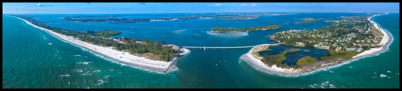
Longboat Pass is a tidal inlet located between Anna Maria Island to the north and Longboat Key south. It is part of a large multi-inlet bay system, where a series of barrier islands separated by several tidal inlets connect the Gulf of Mexico to Sarasota Bay. Tidal inlets are breaks in barrier island systems that allow access and exchange between the high-energy open ocean and the low-energy back-barrier environment consisting of bays, lagoons, tidal marshes, and creeks. The way these inlets work is that strong tidal currents move water and sediments into and out of tidal inlets as the tides rise and fall. As the tide rises on the gulf side, the difference in elevation causes the water to flow into the inlet with a strong current called a flood-tidal current.

When the tide falls outside the inlet, the reverse happens, and the ebb-tidal current flows out of the inlet returning the water to the gulf. The delta deposited on the inside of inlet by the flood tide is a flood tide delta, whereas the delta deposited on the outside of the inlet by the ebb tide is known as an ebb tide delta.

The above image represents how this inlet looked when charted in 1883, and how it looks 100 years after it was developed. In 1883 the main inlet channel was charted further south from where it is today, and it also shows Jewfish Key and Picket Key before they were combined. The 1883 map also shows a smaller inlet approximately 0.5 mi. to the north that has since closed.
Also back in 1883 the gulf waters would come through the pass in a straight line through Pickets Key and Jewfish Key, and then flush the bay every time the tide turned. When the intercoastal water way was dredged in 1939 (The Red Federal Channel line on the 1977 map), the Army Corps of Engineers dumped fill between Jewfish Key and Pickets Key. This union interrupted the flow of water through the pass, and sand started accreting to the land northwest corner of the Long Boat Key.

Looking at the four aerial photos from 1952 to 1969 you can see how the inlet changed over that 17-year period. Dredging for navigation purposes has rearranged the shoals and added sand to the north and south shores of Longboat Pass.
In 1957 the Longboat Pass Bascule Bridge was built, and a jetty was installed on the south end of Anna Maria Island to protect it. A jetty is a breakwater constructed to protect or defend a harbor, stretch of coast, riverbank, or an inlet. They stabilize the inlet’s entrance by intercepting the littoral drift and preventing / minimizing the deposition in the inlet channel. They also minimize the effects of wave action and crosscurrents on vessels transiting the inlet.

The most dramatic change in the photos is the accretion build up created by the filling of Jewfish Key steadily changed the north end of Longboat Key. The accretion started a northern direction, then settled in east along the pass, and created the recurved spit of Greer’s Island. It wasn’t until the 1970’s that it moved south again sealing off the small lagoon that is there today.
Longshore transport is the movement of sediment along a shoreline resulting from a longshore current and from the swash and backwash on a beach face. Also known as littoral drift. Longshore transport moves a tremendous amount of sediment along coasts around the world. The Gulf coast of Florida as a whole exhibits a southbound longshore transport, but here at Longboat Pass coastal studies show a more complicated pattern indicating that longshore transport works in a north-to-south fashion, with a moderate southbound transport.

Sand travels south down Anna Maria Island and into Longboat Pass. The groins placed along it's beaches hold some of the sand and protect the beaches. The Longboat Pass jetty helps to keep sand out of the inlet too, but it also disrupts southern longshore drift to Longboat Key. The inlet traps sand from the beach transport, and that lost sand does not benifit the adjacent beaches to the south.
LOGGING REQUIREMENTS:
To log this Earthcache: Read the geology lesson above. Answer all five questions posted below. Answers can be sent via e-mail or messenger contacts on my Geocaching profile. Group answers are fine, just make sure to note who is in your group.
QUESTION 1. What is the process that causes inlets to open, close, or migrate up and down the beach?
QUESTION 2. What direction does the water appear to be going at the time of your visit? Is this the EBB TIDE or the FLOOD TIDE?
QUESTION 3. Near the center of the drawbridge at the water is a clearance level gauge. What number is the water level at during the time of your visit?
QUESTION 4. Observe the jetty. Does it appear solid and catching sand or does it appear to be failing and leaking sand into the inlet?
QUESTION 5. In 2014 the beach on the inlet side was submerged. Do you feel that this is a manmade beach from dredge or does it appear that this is from sand accreting from the leaking jetty?

OPTIONAL PHOTO. Posting a photo to your log readily indicates that you (and anyone else logging the find) are at the location.
 Awesnap has earned GSA's highest level:

REFERENCES:
1. Longboat Pass Case Study M.DaBeed & N.Kraus, Cumulative Effects of Channel and EBB Shoal Dredging on Inlet Evolution in Southwest Florida, USA, Coastal Engineering 2008, Pages 2303 – 2315 google.com/books
2. Inlet Dynamics, A Historical Geography of Southwest Florida Waterways Vol. 1, G.Antonini, D.Fann, & P.Roat, The Islander, January 1, 2000, Pg.46, PDF, chnep.wateratlas.usf.edu
3. Longboat Key History, website, longboatkeyhistory.com
4. Longboat Key Targets Beer Can Island ... Again, J.McClash, The Bradenton Times, April 7, 2019, Newspaper, thebradentontimes.com
5. Beer Can Island Dredging and Renourishment Planned, J.Hendricks, The Bradenton Times, December 27,2020, Newspaper, thebradentontimes.com
6. Historic Shoreline Changes in Southwest Florida, E.Foster & R.Savage, Coastal Zone'89,the Proceedings of the Sixth Symposium on Coastal and Ocean Management, 1989, Vol. 5, pp. 4420-4433, sarasota.wateratlas.usf.edu
7. Beach issues bridge AMI, LBK, C.Lane, Anna Maria Island Sun, March 6, 2018, amisun.com
8. Tidal Inlet Response to Jetty Construction, James M. Kieslich, Department of the Army Coastal Engineering Research Center, October 1981dtic.mil
9. Drifting the coast in search of places to lay sand, The Islander, www.islander.org
10. Longshore Sediment Transport From Northern Maine To Tampa Bay, Florida: A Comparison Of Longshore Field Studies To Relative Potential Sediment Transport Rates Derived From Wave Information Study Hindcast Data J.Gaalen, University of South Florida, 2004, Page 42, digitalcommons.usf.edu