 (Picture: https://www.luxembourg-city.com/fr/adresse/tour/promenade-unesco)
La Corniche (FR)
La Corniche, appelée également “le plus beau balcon de l'Europe” (selon l'écrivain luxembourgeois Batty Weber), s'étend sur les remparts dressés au XVIIe siècle par les Espagnols et les Français. Tout en longeant la vallée de l'Alzette, le chemin mène du rocher du Bock jusqu'à la partie inférieure de la Citadelle du Saint-Esprit connue sous le nom de rondelles.
Jusqu'en 1870, certaines pentes abruptes de la Corniche furent encore munies d'escaliers; ce ne fut qu'après le démantèlement qu'on les nivela. Une grande partie des remparts garnis de créneaux dut également céder, offrant alors une superbe vue sur la vallée de l'Alzette, la ville basse du Grund et le Plateau du Rham.
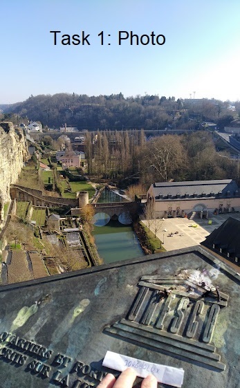
Pour valider votre visite sur place, vous devez satisfaire à la tâche suivante:
Tâche. Photo
Postez une photo de vous ou d'un élément personnel permettant de vous identifier (gps, mascotte, papier avec pseudo,...) avec la plaque UNESCO et une partie de la ville basse à votre log (voir exemple 1 )
-------------------------------------------------------------------------------------------------------------------------------------------
The Corniche (EN)
The Corniche, also called “the most beautiful balcony of Europe” (according to the Luxembourg writer Batty Weber), it runs along the Alzette valley on the ramparts - built by the Spaniards and the French in the 17th century - from the Bock Promontory up to the lower part of the Holy Ghost Citadel, the so-called “Rondellen”.
Up to the year 1870 the Corniche had staircases in steep parts which were levelled off only after the dismantling of the fortress. Moreover the greatest part of the protecting wall with its loopholes was cleared away so as to disclose a superb panorama on the valley of the Alzette, the city district of Grund and the Rham Plateau.
To validate your visit, you must complete the following task:
Task. Photo
Post a photo of yourself or of a personal element allowing to identify you (gps, object, paper with pseudo,...) with the UNESCO plaque and a part of the lower city in your log. (see example 1)
-------------------------------------------------------------------------------------------------------------------------------------------
Die Corniche (DE)
Die Corniche, auch “der schönste Balkon Europas” genannt, verläuft auf den von Spaniern und Franzosen im 17. Jahrhundert errichteten Wällen entlang des Alzette-Tales. Der Weg zieht sich vom Bock-Felsen bis zum unteren Teil der Heiliggeist-Zitadelle, den sogenannten Rondellen.
Bis 1870 war die Corniche an steil abfallenden Stellen mit Treppen versehen; erst nach der Schleifung wurden diese eingeebnet. Auch ein Großteil der mit Schießscharten versehenen Schutzmauern musste weichen und gab somit den Ausblick frei auf das Tal der Alzette, den Stadtteil Grund und das Rham-Plateau.
Um Ihren Besuch vor Ort zu bestätigen, müssen Sie die folgende Aufgabe erfüllen:
Aufgabe. Foto
Poste ein Foto von dir oder einem persönlichen Gegenstand, mit dem du identifiziert werden kannst (GPS, Maskottchen, Papier mit Nickname,...) mit dem UNESCO Schild und einem Teil der Unterstadt an deinem Log (siehe Beispiel 1 )
-------------------------------------------------------------------------------------------------------------------------------------------
(FR)
Je supprimerai sans préavis les logs avec des photos non appropriées .
(EN)
I will delete without notice logs without an appropriate photo.
(DE)
Logs mit ungeeigneten Fotos werde ich ohne Vorwarnung löschen.
BANNER

Copie link Banner: Corniche
<a href="https://coord.info/GC9P72B" target="_blank"><img src="https://s3.amazonaws.com/gs-geo-images/47412f7b-8808-4edf-b4ec-bd7f1192922c_l.jpg" />
Virtual Rewards 3.0 - 2022-2023
This Virtual Cache is part of a limited release of Virtuals created between March 1, 2022 and March 1, 2023. Only 4,000 cache owners were given the opportunity to hide a Virtual Cache. Learn more about Virtual Rewards 3.0 on the Geocaching Blog.