.HITONHAUTA. on jylhä, jääkauden jäljiltä syntynyt rotkolaakso Laukaassa, Valkolan kylässä. Rotko on noin 800 metriä pitkä ja 30–40 metriä leveä, ja sen kallioseinämät kohoavat pystysuorina 10–20 metrin korkeuteen. Rotkon seinämille muodostuu talvisin upeat jääputoukset.
.HITONHAUTA. (A GRAVE OF THE DEVIL) is a rugged gorge valley in the village of Valkola, born after the ice age. The gorge is about 800 meters long and 30-40 meters wide, and its rock walls rise vertically to a height of 10-20 meters. In winter, magnificent ice falls form on the walls of the gorge.

Maasto rotkossa on paikoin todella vaikeakulkuista ja liukasta, ja rotkon pohjalla on runsaasti lohkareikkoa, esim. pitkospuita ei ole. Täällä liikut siis omalla vastuullasi. Talvella lumen tasoittaessa maastopohjan, liikkuminen on huomattavasti helpompaa. Alueen luonto sammalineen ja kasveineen on hyvin herkkää kulumiselle, joten on tärkeää kulkea vain jo valmiiksi tallatuilla poluilla. Nouseminen jyrkänteen rinteille on ehdottomasti kielletty, samoin kuin tulenteko alueella.
The terrain in the gorge is really difficult and slippery in many places, and there are plenty of boulders at the bottom of the gorge. So you move here at your own risk. In winter, when the snow levels the ground, it is much easier to move around. The nature of the area with its mosses and plants is very sensitive to wear and tear, so it is important to walk only on pre-trodden paths. Climbing the slopes is strictly forbidden, as is making fire in the area.

Hitonhaudalle pääsee helpoiten Valkolan kylän suunnasta Valkolantieltä, mistä Harisentien kautta Hitonhaudantielle. Parkkipaikalta (älä aja autolla pidemmälle) on noin 1,3 kilometrin kävelymatka rotkolle johtavan polun alkuun, siinä on myös viitta. Matkan varrelta löytyy kyläyhdistyksen omistama laavu, puuliiteri ja puucee, sekä opasteet Hitonhaudan suuntaan.
The easiest way to get to Hitonhauta is from Valkola village on Valkolantie, from there via Harisentie to Hitonhaudantie. It is about a 1.3 km walk from the car park to the beginning of the path leading to the gorge, there is also a sign. Along the way you will find a shed owned by the village association, a wooden shed and a wooden pee, as well as signs in the direction of Hitonhauta.

Ympäristö on osa Natura 2000 -hanketta. Alueella on neljä luonnonsuojelualuetta, suojelumääräysten mukaan mm. koiran tuominen alueelle ei ole sallittua.
The environment is part of a European Union project to support biodiversity; Natura 2000. There are four nature reserves in the area, e.g. dogs are not allowed in the area.
Tehtävä
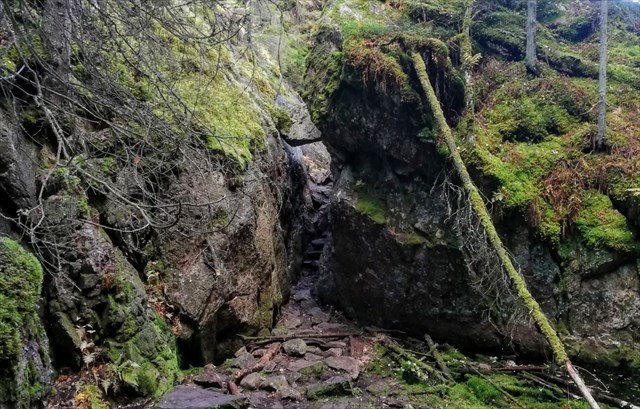
Mene annettuihin koordinaatteihin niin näet kuinka kivenlohkare on kiilautunut kallioiden väliin, sen ali pääsee kulkemaan kuin portista. Ota kuva jossa kivenlohkareen lisäksi näkyy jotain sinun omistamaasi tai sinä itse. Kasvosi ei tarvitse näkyä kuvassa. Voit lokata virtuaalin löydetyksi, kun liität ottamasi kuvan lokiin. Lokkaukset ilman vaadittavaa kuvaa tullaan poistamaan. Seuraavissa kuvissa näkymä polulta kivenlohkarepaikasta sekä ylä- että alapuolelta kuvattuna.
Mission
Go to the given coordinates so you can see how the boulder is wedged between the rocks, you can walk under it like through a gate. Take a picture that, in addition to the boulder, shows something you own or yourself. Your face does not need to be shown in the image. You can locate the virtual found when you attach the captured image to the log. Lockouts without the required image will be removed. The following images show a view of the boulder from the path both above and below.

Virtual Rewards 3.0 - 2022-2023
This Virtual Cache is part of a limited release of Virtuals created between March 1, 2022 and March 1, 2023. Only 4,000 cache owners were given the opportunity to hide a Virtual Cache. Learn more about Virtual Rewards 3.0 on the Geocaching Blog.