Description en français
Pour notre récompense virtuelle, nous vous proposons une randonnée en forêt pour découvrir un des plus bel endroit du parc de la Gatineau: les Ruines Carbide Willson. C'est un endroit très prisé des photographes.
Le parc de la Gatineau est un parc de conservation mais ici et là, on retrouve des vestiges d’un passé plus industriel. À cet endroit, Thomas Leopold Willson a construit, dans les années 1910: un barrage, une station génératrice et une tour de condensation d’acide pour fabriquer de l'engrais. Vous pouvez toujours voir aujourd’hui les vestiges de ces constructions.
Pour enregistrer cette cache comme trouvée, vous devrez:
- Envoyer nous par messagerie de geocaching la réponse à la question suivante: Sur le panneau d'interprétation près des coordonnées publiées il y a une image. Quels sont les 5 derniers chiffres du numéro d'identification de l’image: ANC/NAC PA1 _ _ _ _ _ ? Changement en novembre 2025: le panneau d'interprétation a été retiré durant les rénovations sur le site. Les nouveaux panneaux seront installés au printemps 2026. D'ici là, vous n'avez qu'à inclure la photo dans votre log.
- Pour démontrer que vous avez bel et bien visité le site, prenez une photo avec un élément vous identifiant (papier avec votre nom de géocacheur inscrit dessus, votre GPS, votre visage, ...) et les ruines en arrière plan. Ajouter cette photo à votre log.
Les logs qui ne rencontreront pas ces exigences seront effacés.
Informations pratiques:
- Pour se rendre à Carbide Willson: À partir de P11, prendre le sentier 36 et 36B jusqu'aux ruines. C’est une randonnée aller-retour de 3.25 km sur un sentier bien balisé et qui peut parfois être très boueux. Le dénivelé total est de 120 m. Prévoyez au moins une heure pour votre randonnée. Prenez le temps d'admirer le lac Meech en chemin.
- Lorsque la plage O'Brien est ouverte, le stationnement est payant (de la fin juin au début septembre environ).
- Nouveau pour l’hiver 2022-23: les ruines sont maintenant accessibles en ski de fond (même trajet qu'en été). Il est maintenant aussi possible de s'y rendre en raquettes ou vélo d'hiver à partir de P16, en empruntant les sentiers 45 et 44. C’est un trajet de plus de 12 km aller-retour.
- En hiver, une passe de ski ou raquette est requise.

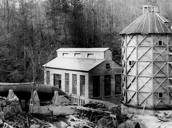
Circa 1913
Image de la Société Historique de la Vallée de la Gatineau
Image from the Gatineau Valley Historical Society
English Description
For our virtual reward, we invite you to take a hike in the woods to discover one of the prettiest sites in the Gatineau Park: the Carbide Willson Ruins. This site is very popular with photographers.
Gatineau Park is a conservation park but here and there, you can still see evidence of a more industrial past. At this location, in the 1910’s, Thomas Leopold Willson built an acid condensation tower, a dam and a generating station which made up a fertilizer plant. Today, you can still see the remains of these buildings.
Logging requirements:
- Via the geocaching messaging system, send us the answer to the following question: On the interpretation panel near the published coordinates, there is a picture. What are the last 5 digits of the picture identification number: ANC/NAC PA1 _ _ _ _ _ ? Update on November 2025: the interpretation panel has been removed during the site renovation. The new panels will be installed in the spring of 2026. Until then, you only need to post a picture with your log.
- To prove that you visited the site, take a picture of an identifying element (paper with your geocaching name on it, your GPS, your face, ...) with the ruins in the background. Include the picture in your log.
Logs that don't meet the requirements above will be deleted.
Practical information:
- To get to Carbide Willson: From P11, take trails 36 and 36B to the ruins. From the trail head, it is a 3.25 km round trip hike on a well marked trail that can be muddy at times. The total ascent is 120 m. You should plan at least 1 hour for your hike. Enjoy the views of Meech Lake along the way.
- When O’Brien beach is open (usually end of June to beginning of September), there is a fee for parking.
- New starting in winter 2022-23: it is now possible to access the ruins by cross-country ski (same route as in the summer). It is also possible to get there by snowshoe or snow bike starting from P16, and taking trails 45 and 44. It is a return trip of over 12 km.
- In winter, a ski or snowshoe pass is required.
Virtual Rewards 3.0 - 2022-2023
This Virtual Cache is part of a limited release of Virtuals created between March 1, 2022 and March 1, 2023. Only 4,000 cache owners were given the opportunity to hide a Virtual Cache. Learn more about Virtual Rewards 3.0 on the Geocaching Blog.