This is a Mystery (Puzzle) Cache. Do not go to the posted coordinates unless you have been advised you have a parcel to pick up from the Rural Delivery Service – the cache is not there.
An important part of any community is its local ‘Postie’. This is especially so for rural communities where the Rural Delivery service is a crucial part of supporting the rural economy and linking people and families to goods and services that otherwise would require them to travel to their nearest town or city, which may take half a day or even longer.
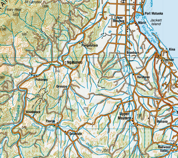
This Mystery Cache is a tribute to the posties operating the Rural Delivery service out of Sarau (also known as and shown on the map as Upper Moutere). It is based on their area of responsibility and local roads.
The map below provides an overview of the geography, and the road network of the locations they service:
Because the most significant component in the total cost of the delivery service is labour, minimising delivery time is critical to managing cost. Distance, vehicle type, time of day and road design, road maintenance, one-way/two-way etc. are all factors that contribute to travel time.
In this instance there are complicating factors on part of the run caused by the flooding of the Motueka River and ensuing road works. This has resulted in some roads which are one-way only, and others have different travel times going one way vs. the other because of the Stop-Go / Traffic Management protocols.
You need to travel to each of the locations listed in the table below, and should only visit each location once. The travel times between each of these destinations, in minutes, is shown below:
|
Travel Time (Minutes)
|
To
|
|
Sarau
|
Mahana
|
Harakeke
|
Dovedale
|
Braeburn
|
Thorpe
|
Orinoco
|
Woodstock
|
Ngatimoti
|
Lower Moutere
|
Tasman
|
Pangatotara
|
Pokororo (West)
|
|
From
|
Sarau
|
0
|
7
|
4
|
14
|
8
|
20
|
15
|
29
|
17
|
11
|
13
|
23
|
28
|
|
Mahana
|
7
|
0
|
4
|
19
|
9
|
26
|
21
|
33
|
25
|
12
|
8
|
20
|
40
|
|
Harakeke
|
4
|
4
|
0
|
17
|
4
|
23
|
18
|
34
|
21
|
8
|
6
|
25
|
36
|
|
Dovedale
|
14
|
19
|
17
|
0
|
23
|
6
|
15
|
16
|
22
|
25
|
25
|
27
|
26
|
|
Braeburn
|
8
|
9
|
4
|
23
|
0
|
26
|
27
|
36
|
18
|
3
|
7
|
20
|
40
|
|
Thorpe
|
20
|
26
|
23
|
6
|
26
|
0
|
9
|
7
|
17
|
31
|
33
|
31
|
22
|
|
Orinoco
|
15
|
21
|
18
|
15
|
27
|
9
|
0
|
16
|
8
|
28
|
35
|
20
|
21
|
|
Woodstock
|
29
|
33
|
34
|
16
|
36
|
7
|
16
|
0
|
21
|
38
|
40
|
24
|
17
|
|
Ngatimoti
|
17
|
25
|
21
|
22
|
18
|
17
|
8
|
27
|
0
|
25
|
43
|
18
|
15
|
|
Lower Moutere
|
11
|
12
|
8
|
25
|
3
|
31
|
28
|
38
|
25
|
0
|
9
|
15
|
19
|
|
Tasman
|
13
|
8
|
6
|
25
|
7
|
33
|
35
|
40
|
35
|
9
|
0
|
23
|
35
|
|
Pangatotara
|
23
|
20
|
25
|
33
|
20
|
26
|
20
|
19
|
12
|
18
|
25
|
0
|
15
|
|
Pokororo (West)
|
28
|
31
|
27
|
26
|
31
|
22
|
17
|
13
|
9
|
25
|
37
|
21
|
0
|
For the reasons explained above, not all routes are symmetric – e.g. it takes 15 minutes to go from Pangatotara to Pokororo (West), but it takes 21 minutes to go from Pokororo (West) to Pangatotara.
To solve this mystery, you need to determine the minimum travel time and route, travelling to each of the listed locations only once. The travel time information in the table above is the only information you should use - the map, Google or other resources should not be used.
Once you have determined the minimum time and travel route, call the minimum travel time XYZ minutes, and number each location sequentially in the order you visit them – starting with Sarau = 1 through to the 13th location, and then ending back at the Sarau Depot. The sequence will provide you the values for b, c, d, f, g, and h.
The cache can be found at S41° 1a.b.c.d’ E172° ef.ghj’ where:
a = Z, b = Ngātimoti, c = Lower Moutere, d = Mahana
e = Z-Y, f = Ngātimoti, g = Mahana, h = Pangatotara, j = Ngātimoti
The Cache is a Micro – bring your own pen.