
Valle de Viñales
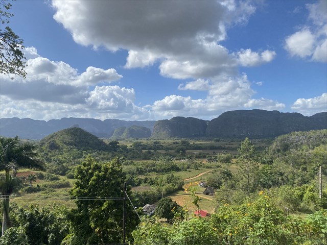
Me gustaría acercarte a uno de los valles más hermosos de Cuba con este Earth Cache: El Valle de Viñales. Se encuentra en el oeste de Cuba, en la provincia de Pinar del Río, y se extiende a lo largo de más de 10 km. Desde 1999, este maravilloso parque nacional con sus montañas kársticas de 160 millones de años está protegido por la UNESCO.
En las montañas kársticas, llamadas mogotes, existen alrededor de 10'000 cuevas, que fueron habitadas por los guanahatabeyes, nativos del occidente de Cuba, y que luego sirvieron de escondite a los esclavos fugados. Como panes de azúcar verdes, las rocas cónicas se elevan de la tierra marrón rojiza.
Un buen lugar para contemplar los mogotes es el Mural de la Prehistoria. Allí encontrará una obra de arte de 120 metros de altura que representa el proceso evolutivo de la vida.
Geología
Jurásico (hace ~201,3 millones - 145 millones de años)
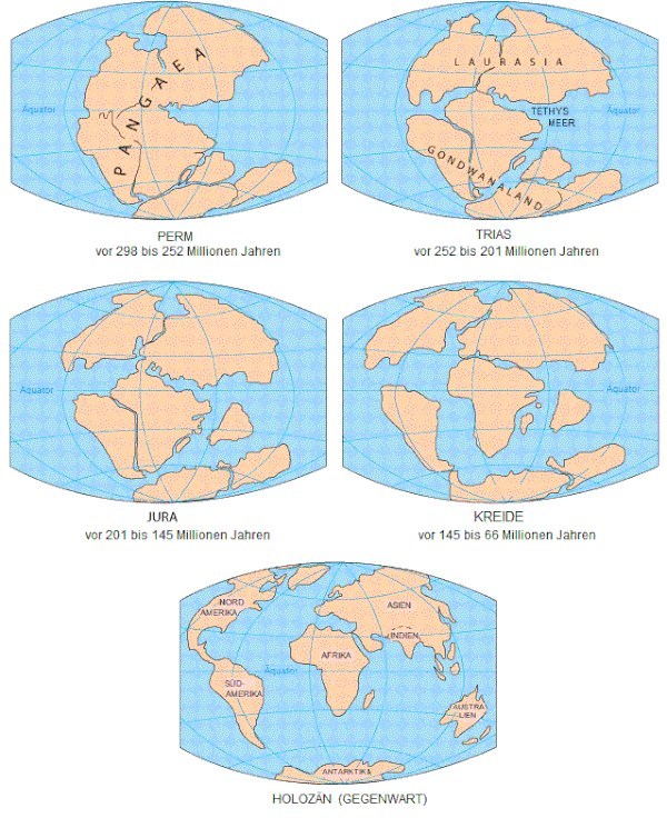
La fragmentación del supercontinente Pangea conduce a la separación de los continentes americanos. Se crea una cuenca marina profunda en la que se depositan sedimentos en tres entornos diferentes: sedimentos terrestres en las zonas húmedas de los deltas, sedimentos carbonatados en las plataformas y en las aguas profundas del margen continental norteamericano.
Período cretácico (hace ~145 millones - 66 millones de años)
Durante el Cretácico Inferior continúan acumulándose sedimentos en las plataformas carbonatadas, mientras que en el Cretácico Superior cesa la sedimentación en los tramos de la Sierra de Órganos. Al mismo tiempo, hacia el final de este período, un meteorito impactó en la zona de Chicxulub (Yucatán, México), desencadenando una catástrofe. Hay deslizamientos de tierra, grandes tsunamis causados por deslizamientos de tierra bajo el agua. Como resultado, las masas de sedimentos en la región se depositan de manera caótica.
Paleógeno (hace ~66 millones - 23,03 millones de años)
Los sedimentos de carbonato se acumulan en aguas profundas. Debido a las grandes deformaciones por compresión (construcción de montañas cubanas), hay un gran desplazamiento de las áreas fronterizas de América del Norte. Esto crea placas tectónicas y un movimiento caótico de los sedimentos (olistostromos). La región se crea y se crean cerros, valles, sumideros y cuevas por el inicio de los procesos de erosión.
Neógeno (hace ~23,03 millones - 2,588 millones de años)
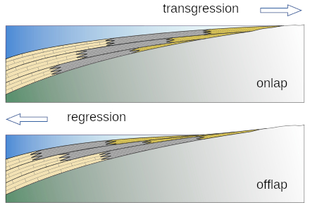
Durante el Plioceno (hace 5.333 - 2.588 millones de años) y el Pleistoceno (2.588 millones - 11.700 años AP) prevalecen condiciones marinas, fluviales y lacustres en los valles alrededor de los mogotes. Debido a los sucesivos movimientos de avance y retroceso del agua (transgresiones y regresiones) asociados con las últimas glaciaciones, el terreno se profundiza hasta su forma actual: mogotes aislados, cadenas montañosas calcáreas y sumideros intermedios, y hasta 6 niveles diferentes de cuevas.
Al caché
Para registrar este caché, debe responder a las siguientes preguntas:
- ¿Qué consecuencias tuvo para el Valle de Viñales el impacto del meteorito de Chicxulub?
- ¿Cómo se llaman los movimientos de avance y retroceso del agua que, en relación con las últimas glaciaciones, dieron al valle su forma actual?
- Al pie del mural, el mogote está sin pintar. Describe el color y la estructura de la roca. ¿Ves alguna inclusión? Si es así, ¿cuáles?
- Hay un tablero de información en el sitio. ¿Qué aparece junto al título?
- Opcional - una foto suya o de un objeto personal delante del Mural de la Prehistoria sería apreciada. Pero, por favor, no lo estropees.
Envíame tus respuestas por correo electrónico o centro de mensajes. Entonces, puedes registrarte directamente. Me pondré en contacto con usted si las respuestas son incorrectas. Los registros sin respuesta serán eliminados sin comentarios.
Fuente: Información turística de Viñales & Wikipedia

Viñales Valley (Cuban Valle de Viñales)
The Viñales Valley (Valle de Viñales in Cuban), one of the most beautiful valleys in Cuba, is what I would like to introduce to you with this Earth Cache. It is located in the west of Cuba in the province of Pinar del Río and stretches over a length of more than 10 km. Since 1999, this magnificent national park with its 160 million year old karst mountains is under UNESCO protection.
In the karst mountains, called mogotes, there are about 10,000 caves, which were inhabited by the Guanahatabeyes, indigenous people of western Cuba, and later served as hiding places for escaped slaves. Like green sugar loaves, the conical rocks rise from the brown-red earth.
A nice place to admire the conical mountains is at the Mural de la Prehistoria. There is a 120m high artwork, which depicts the evolution of life.
Geology
Jurassic (~201.3 million - 145 million years ago)
The fragmentation of the supercontinent Pangaea leads to the separation of the American continents. A deep-sea basin is created in which sediments are deposited in three different environments: terrestrial sediments in the wetlands of the deltas, carbonate sediments on the shelves and in the deep waters of the North American continental margin.
Cretaceous period (~145 million - 66 million years before our time)
During the Early Cretaceous, sediments continue to accumulate in the carbonate platforms, while in the Late Cretaceous sedimentation stops in the Sierra de Órganos sections. At the same time, a meteorite strikes the Chicxulub area (Yucatán, Mexico) towards the end of this period, triggering a catastrophe. Landslides occur, large tsunamis caused by landslides under water. As a result, sediment masses are deposited in the region in a chaotic way.
Palaeogene (~66 million - 23.03 million years before our time)
Carbonate sediments accumulate in deep waters. Large compressional deformations (Cuban mountain building), cause a large displacement of the North American margins. This creates tectonic plates and a chaotic movement of sediments (olisthostromes). The region is formed and hills, valleys, sinkholes and caves are created by incipient erosion processes.
Neogene (~23.03 million - 2.588 million years ago)
During the Pliocene (5.333 - 2.588 million years ago) and the Pleistocene (2.588 million years ago - 11,700 years BP), marine, fluvial and lake-like conditions prevailed in the valleys around the Mogotes. Successive forward and backward movements of water (transgressions and regressions) associated with the last ice ages deepened the terrain to its present form: Freestanding mogotes, calcareous mountain ranges and dolines in between, as well as up to 6 different levels of caves.
To the cache
To log this cache, you must answer the following questions:
- What were the consequences for the Viñales Valley of the meteorite impact in Chicxulub?
- What are the names of the forward and backward movements of the water that, in connection with the last ice ages, gave the valley its present shape?
- At the foot of the mural, the mogote is unpainted. Describe the colour and structure of the rock. Do you see any inclusions? If so, which ones?
- There is an information board on the site. What is shown next to the title?
- Optional - a photo of you or a personal item of yours in front of the Mural de la Prehistoria would be appreciated. But please do not spoil it!
Send your answers to me by email or message centre. Then you can log directly. I will contact you if the answers are wrong. Logs without an answer will be deleted without comment.
Source: Tourist Information Viñales & Wikipedia

Viñales-Tal (kubanisch Valle de Viñales)
Das Viñales-Tal (kubanisch Valle de Viñales), eines der schönsten Täler Kubas, möchte ich euch mit diesem Earth-Cache näher bringen. Es liegt im Westen Kubas in der Provinz Pinar del Río und erstreckt sich über eine Länge von über 10 km. Seit 1999 steht dieser wunderbare Nationalpark mit den rund 160 Millionen Jahre alten Karstbergen unter dem Schutz der UNESCO.
In den Karstbergen, Mogotes genannt, befinden sich um die 10'000 Höhlen, welche von den Guanahatabeyes, Ureinwohnern Westkubas, bewohnt wurden und später den entflohenen Sklaven als Versteck dienten. Wie grüne Zuckerhüte erheben sich die Kegelfelsen aus der braunroten Erde.
Ein schöner Ort um die Kegelberge auf sich wirken zu lassen ist bei der Mural de la Prehistoria. Dort befindet sich ein 120 m hohes Kunstwerk, welches den evolutionären Prozess des Lebens darstellt.
Geologie
Jura (~201,3 Mio - 145 Mio Jahren vor unserer Zeit)
Die Zersplitterung des Superkontinents Pangaea führt zur Trennung der amerikanischen Kontinente. Es entsteht ein Tiefseebecken, in dem sich die Sedimente in drei verschiedenen Umgebungen ablagern: Erdsedimente in den Feuchtgebieten der Deltas, Karbonatssedimente auf den Schelfen sowie in den tiefen Gewässern des nordamerikanischen Kontinentalrandes.
Kreidezeit (~145 Mio - 66 Mio Jahren vor unserer Zeit)
Während der frühen Kreidezeit häufen sich die Sedimente in den Karbonatplattformen weiter an, während in der späten Kreidezeit die Sedimentation in den Abschnitten der Sierra de Órganos aufhört. Gleichzeitig schlägt in der Gegend von Chicxulub (Yucatán, Mexiko) gegen Ende dieses Zeitraums ein Meteorit ein und löst eine Katastrophe aus. Es kommt zu Erdrutschen und grossen Tsunamis durch Erdrutsche unter Wasser. Als Folge lagern sich die Sedimentmassen in der Region auf chaotische Weise ab.
Paläogen (~66 Mio - 23,03 Mio Jahren vor unserer Zeit)
Karbonatssedimente reichern sich in tiefen Gewässern an. Durch grosse Kompressions-Deformationen (kubanische Gebirgsbildung), kommt es zu einer grossen Verschiebung der nordamerikanischen Randgebiete. Dabei entstehen tektonische Platten und eine chaotische Bewegung der Sedimente (Olisthostrome). Die Region entsteht und durch beginnende Erosionsprozesse bilden sich Hügel, Täler, Dolinen und Höhlen.
Neogen (~23,03 Mio - 2,588 Mio Jahren vor unserer Zeit)
Während des Pliozäns (vor 5,333 - 2,588 Mio Jahren) und des Pleistozäns (2,588 Mio Jahren - 11’700 Jahre BP) herrschen in den Tälern rund um die Mogoten marine, fluviale und seenartige Bedingungen. Durch die sukzessiven Vorwärts- und Rückwärtsbewegungen des Wassers (Transgressionen und Regressionen) in Verbindung mit den letzten Eiszeiten, vertieft sich das Gelände bis zu seiner heutigen Form: Freistehende Mogoten, kalkhaltige Gebirgszüge und dazwischen Dolinen sowie bis zu 6 verschiedene Ebenen von Höhlen.
Zum Cache
Um diesen Cache zu loggen, musst du folgende Fragen beantworten:
- Welche Folgen für das Viñales-Tal hatte der Meteoriteinschlag in Chicxulub?
- Wie heissen die Vorwärts- und Rückwärtsbewegungen des Wassers, welche in Verbindung mit den letzten Eiszeiten dem Tal die heutige Form gaben?
- Am Fuss des Wandgemäldes ist der Mogote unbemalt. Beschreibe die Farbe und Struktur des Felsen. Siehst du Einschlüsse? Falls ja, welche?
- Es befindet sich eine Infotafel auf dem Gelände. Was ist neben dem Titel abgebildet?
- Optional - ein Foto von dir oder einem persönlichen Gegenstand von dir vor der Mural de la Prehistoria würde mich freuen. Aber bitte nicht spoilern!
Schickt eure Antworten per Mail oder Nachrichtencenter an mich. Danach dürft ihr direkt loggen. Bei falschen Antworten melde ich mich. Logs ohne Antwortmail werden kommentarlos gelöscht.
Quelle: Tourist-Info Viñales & Wikipedia