
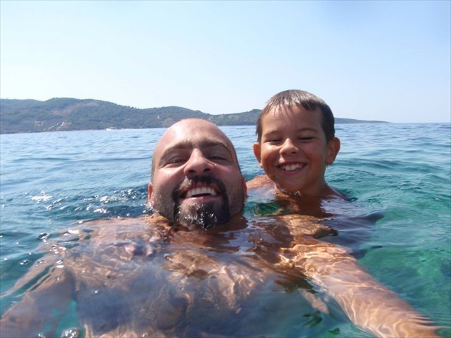
Rok i Ribafish, sin i otac, bili su geocacheri amateri i skupili su preko 300 cacheva sa svih strana svijeta. Imali su plan zajedno posjetiti sve naseljene hrvatske otoke, no njihovu avanturu je prekinula sudbina. Danas, Rok više nije na ovom svijetu, ali tata Ribafish ispunjava obećanje koje mu je dao - da će posjetiti sve hrvatske naseljene otoke, pa stvara Udrugu i projekt #RokOtok, edukacijsko plivački maraton u kojem će kroz tri godine i pedesetak etapa preplivati udaljenosti između svih 50 hrvatskih naseljenih otoka. Ujedno, na svakom otoku će pokušati drugim klincima razviti svijest o važnosti provođenja zajedničkog vremena roditelja i djece kroz sport, druženje, učenje, istraživanje, kao i važnost očuvanja prirode. Geocaching se također promovira kao jedna aktivnost koja odvlači djecu od buljenja u igrice na ekranu prema avanturi, orijentaciji i istraživanju prirode.
Projekt je počeo u ljeto 2019. kad je preplivao preko 100 km spajajući 17 naseljenih otoka u južnom Jadranu. Zbog poznate Covid situacije i ograničenja preskočena je 2020. godina, a u ljeto 2021. slijedi avantura na Srednjem Jadranu, kad će se plivajući obići 17 novih otoka.
Hrvatski geocacheri su se okupili i napravili “ekološke” cacheve koji će uz prigodnu prezentaciju o geocachingu biti postavljeni na tih 17 otoka. Ovo je jedan od cacheva iz serije.
Za više detalja o projektu #RokOtok posjetite stranicu www.rokotok.hr, a kako je cijeli projekt prilično medijski popraćen, za aktuelne informacije jednostavno izguglajte!

Pag
Otok Pag površinom je peti najveći otok u Jadranskom moru, ali je duljinom obale od 302,47 km najrazvedeniji otok Jadrana (koeficijent razvedenosti 4,5).
Otok je poznat po slaboj pokrivenosti vegetacijom nekih svojih dijelova, čiji se kameniti krajobraz s aromatičnim biljem često uspoređuje s Mjesečevom površinom. Zbog položaja otoka pod Velebitom s kojeg cijele godine (osobito zimi) pušu jake bure, otok Pag je gotovo čitav prekriven posolicom iz Velebitskoga kanala. Na otok se, s južne strane, može stići mostom, dugim 340 m, iz pravca Zadra, tj. Posedarja ili trajektom u Žigljen na sjeveru otoka iz luke Prizna.
Otok Pag bio je naseljen već u neolitiku. Najstariji poznati naziv otoka, Kissa, predilirskog je podrijetla. U zaseoku Metajna na brežuljku Zaglava, postoje ostaci zidnih slikarija nepoznate starosti, koje prikazuju ljudske likove. Nađeni su ostaci većeg broja gradinskih naselja i grobnih humaka (tumula) iz brončanog i željeznog doba. Grobni humci nalaze se na Punti Luna, rtu Gradašnici, Kozjem Brdu (grobni humak iz brončanog doba) i Vrčićima. Ostaci pretpovijesnih gradina i danas se mogu vidjeti na sljedećim lokalitetima: Punta Luna, Gradac - Konobine, rt Gradašnica, Košlja Gromača, Svetojanj, Košljun (Kissa), Zagračišće, Komorovac, Zaglava, Gračišće, Gornji Gradac, Donji Gradac, brdo Sv. Vid, Gradac kod grada Paga, grad Pag, Kruna, Gorica, Gramajnik (Dinjiška), Panos, Vlašići, rt Mrtva.

Rok and Ribafish, son and father, were amateur geocachers and they found over 300 caches from all over the world. They had a plan to visit all the inhabited Croatian islands together, but their adventure was interrupted by fate. Today, Rok is no longer in this world, but dad Ribafish fulfills the promise he gave him - that he will visit all Croatian inhabited islands. So, he created the Association and the project #RokOtok (Otok = island in Croatian), an educational swimming marathon in which he will connect all 50 Croatian inhabited islands by swimming, in three years and fifty(ish) stages. At the same time, on each island he will try to educate children and develop their awareness of the importance of spending time with their parents through sports, socializing, learning, research, as well as the importance of nature conservation. Geocaching is also promoted as one activity that distracts children from staring at on-screen games towards adventure, orientation and nature exploration.
The project began in the summer of 2019 when he swam over 100 km connecting 17 inhabited islands in the Southern Adriatic. Due to the well-known Covid situation and limitations, the year 2020 was skipped, but in the summer of 2021 an adventure in the Central Adriatic is scheduled, when 17 new islands will be visited by swimming.

Croatian geocachers gathered for this project and made "ecological" caches that will be placed on these 17 islands with a short presentation on geocaching. This is one of the caches from the series.
For more details about the #RokOtok project, visit the page www.rokotok.hr, and as the whole project is quite covered by the media, just google it for current information!
Pag
The island of Pag is the fifth largest island in the Adriatic Sea by area, but with a coastline of 302.47 km, it is the most indented island in the Adriatic (indentation coefficient 4.5).
The island is known for its sparse coverage of vegetation in some parts, whose rocky landscape with aromatic herbs is often compared to the surface of the moon. Due to the location of the island under Velebit, from which strong gales blow all year round (especially in winter), the island of Pag is almost entirely covered with salt from the Velebit channel. The island can be reached from the south side by a bridge, 340 m long, from the direction of Zadar, i.e. Posedarje, or by ferry to Žigljen in the north of the island from the port of Prizna.
The island of Pag was already inhabited in the Neolithic. The oldest known name of the island, Kissa, is of pre-Illyrian origin. In the hamlet of Metajna on the hill of Zaglava, there are remains of wall paintings of unknown age, which depict human figures. The remains of a large number of castle settlements and burial mounds (tumuli) from the Bronze and Iron Ages were found. Burial mounds are located on Punta Luna, Cape Gradašnica, Kozje Brdo (burial mound from the Bronze Age) and Vrčići. The remains of prehistoric fortifications can still be seen today in the following locations: Punta Luna, Gradac - Konobine, rt Gradašnica, Košlja Gromača, Svetojanj, Košljun (Kissa), Zagračišće, Komorovac, Zaglava, Gračišće, Gornji Gradac, Donji Gradac, hill of St. Vid, Gradac near the city of Pag, the city of Pag, Kruna, Gorica, Gramajnik (Dinjiška), Panos, Vlašići, Cape Mrtva.
