
Springs and Sapping Valleys
A valley is an elongated low area often running between hills or mountains, which will typically contain a river or stream running from one end to the other. Most valleys are formed by erosion of the land surface by rivers or streams over a very long period (Wikipedia).
Hemlock Crossing has sapping valleys, which are different from the more typical V-shaped valleys that are formed by rivers or streams. A sapping valley is formed by ground water that hits an impermeable rock or clay layer and flows out through a spring, slowly eroding the underground sediment layer. When enough sediment has been eroded below the surface, the weight of the upper soil layers causes it to collapse, forming a U-shaped valley.
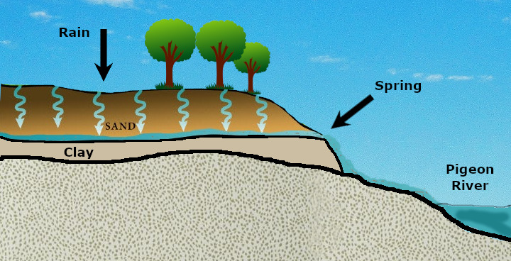
At stage 1, you will find one of these active springs. If you look north from the spring, you are looking into a sapping valley. The springs in this area removed underground sand over a period of time. When enough sand had been removed, the upper layers of soil collapsed forming the U-shaped sapping valley.
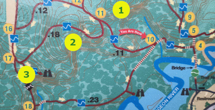
Hemlock Crossing has three sapping valleys. They can be seen in the contour lines of the map above and are labeled 1, 2, 3. For this earthcache, you will visit four stages and be looking at sapping valleys 1 & 3 on the above map.
In order to log this Earthcache...
Please read the following questions and send me your answers.
- At the posted coordinates, where is the water coming from? Would you have known this was a spring if it had not been pointed out to you? Take note of what stands out, as this will help you at stage 4.
- Walk from the posted coordinates to stage 2, how deep is the sapping valley? What is the shape and size of the valley at stage 2?
- Go to stage 3 and compare the size of this sapping valley to the first one.
- Go to stage 4. How many springs do you see in this valley? How can you tell that they are springs?
- If you are present during freezing weather, are the springs frozen?
- Feel free to post a picture of yourself somewhere at Hemlock Crossing.
Sources:
Groundwater Springs and Sapping Valleys in Ottawa County, Michigan by Larson, Riemersma and Colgan.