[ENGLISH]
Kopiec Kościuszki
Został usypany w latach 1820-1823 na cześć bohatera narodowego, Tadeusza Kościuszki. W latach 1850–1856 wokół kopca powstał fort cytadelowy 2 „Kościuszko”, największy w Twierdzy Kraków. Z kopca możemy podziwiać panoramę Krakowa, a w pogodne dni także pasm górskich.

Kopiec Kościuszki 2022 r.
Zagadka
Przed wycieczką na Kopiec Kościuszki udamy się na hipotetyczny kopiec, na który prowadzi ścieżka po 4 okręgach. Na kolejne można wchodzić tylko w punktach styczności. Średnica ścieżki po największym okręgu to 70 m, różnice długości średnic kolejnych okręgów są takie same, a najmniejsza okrężna ścieżka ma średnicę równą sumie różnicy średnic dwóch stycznych okręgów i dwóch trzecich tej różnicy. Pytanie: ile kalorii spalimy wchodząc na kopiec? No nie, żartowałam, tak naprawdę chodzi o to, jaką drogę trzeba przebyć, by dotrzeć na platformę widokową. Pomijamy kwestię nachylenia kopca. Wynik zaokrąglony do liczby całkowitej to X, które podstawiamy do wzoru na współrzędne pojemnika (zaokrąglałam na końcu w popularnym arkuszu kalkulacyjnym).
N 50° 3.[X - 100]' E 19° 53.[X + 448]'
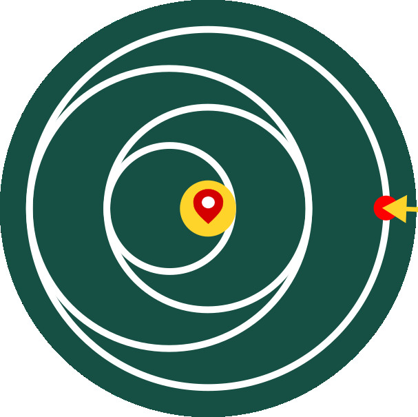 Zagadka | The riddle
The riddle
Before the trip to the Kościuszko Mound, we will go to the hypothetical mound along paths located on 4 circles. The next circle path can only be entered at the tangent point. The diameter of the path along the largest circle is 70 m, the differences in the diameters of the consecutive circles are the same, and the smallest circular path has a diameter equal to the sum of the difference in the diameters of the two tangent circles and two-thirds of the difference. Question: how many calories will we burn by climbing the mound? Oh no, I was just kidding, it really is about the path you have to walk to reach the viewing platform. We ignore the slope of the mound. The result rounded to an integer should replace X in the formula for the container coordinates (I rounded only the final result in a popular spreadsheet).
N 50° 3.[X - 100]' E 19° 53.[X + 448]'
The Kościuszko Mound
It was erected in the years 1820-1823 in honor of the Polish national hero Tadeusz Kościuszko. In the years 1850–1856, the citadel fort 2 "Kościuszko", the largest in the Krakow Fortress, was built around the mound. From the mound we can admire the panorama of Krakow, and on clear days also the mountain ranges.

Part of the Fort "Kościuszko"