Scotts Bluff is located in western Nebraska and towers more than 800 feet above the North Platte River. The bluff served as an important landmark on the Oregon Trail, California Trail and Pony Express Trail, and was visible at a distance from the Mormon Trail. Over 250,000 westward emigrants passed by Scotts Bluff between 1843 and 1869 and it was the second most referred to landmark in pioneer journals and diaries (after Chimney Rock).
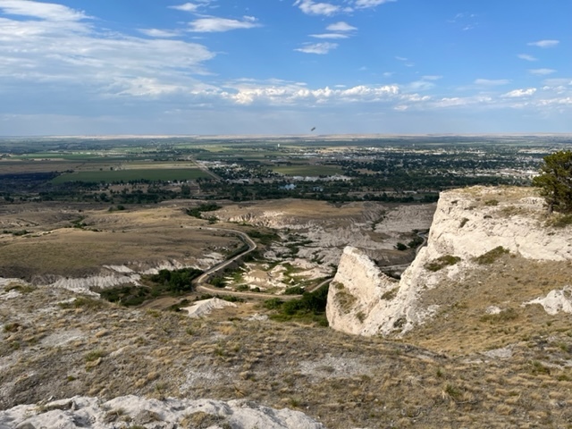
The Orella Badlands cover 500 acres and consist of domes (formation in shape of a dome), ravines (deep narrow gorges with steep sides), plateaus (areas of relatively high level ground), tunnels, and arches. When the humidity is high, the whole area which is normally pale yellow turns to various hues of pink and red. Many fossilized animal remains have been found here, principally turtle shells and Oredont skulls. This tortured land led the Indians to name the bluffs “Me-a-pa-te”, which translates to “hill hard to go around”. It also forced wagon trains to journey further south to find a way back to the river. The badlands are an example of rapid erosion in soft rock beds of similar uniform composition. The main rock formation in this section is Brule clay, which is very soft and sand like, and as a result it erodes quite easily. When this clay is unprotected by more durable formations, erosion produces a pattern of irregular gullies known as “badlands”. The oldest exposed rocks are of the Orella Member of the Brule Formation and White River Group and are roughly 33 million years old. This is the badlands area that you see in front of you and consists of siltstones and mudstones with interbedded thin lenticular (shaped like lentil) sandstones. The sandstone and siltstone layers that you see represent floodplain and channel deposits of ancient streams that flowed eastward from the Rocky Mountains as they were being uplifted.
Logging Requirements:
- Describe the badlands that you see in front of you. What color are they? Why do you think high humidity causes them to appear to be a different color?
- What type of formations appear to be most common in these badlands (domes, ravines, plateaus, tunnels, or arches)? Why do you think this is the case?
- It has been estimated that the badlands in South Dakota erode at a rate of roughly 1 inch/year. Assuming that the badlands in front of you are eroding at a similar rate, how do you think this area will look 100 years from now? 500 years from now? 1000 years from now?
- Upload a photo taken from the North Overlook with the Badlands in the background. You don't have to be in the photo though it is strongly encouraged.