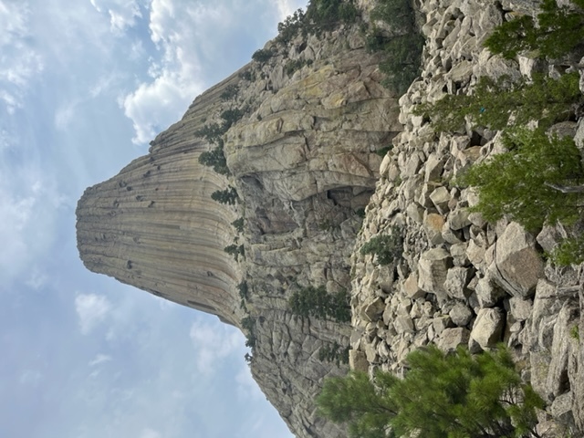
Devils Tower National Monument is located in northeast Wyoming and is the nations first national monument, having been established in 1906 by President Theodore Roosevelt. Devils Tower is a butte, possibly laccolithic (body of intrusive rock with a dome-shaped upper surface and a level base, fed by a conduit from below), composed of igneous rock that is 867 feet tall and rises above the Belle Fourche River. The name Devils Tower originated in 1875 during an expedition led by Colonel Richard Irving Dodge, when his interpreter reportedly misinterpreted a native name to mean 'Bad God's Tower'.
The area surrounding Devils Tower is composed mostly of sedimentary rocks. The oldest rocks are part of the Spearfish Formation and are located along the Belle Fourche River. They were laid down when the area was a shallow sea during the Triassic Period. These rocks are mostly dark red sandstone (caused by oxidation of minerals containing iron) and maroon siltstone with occasional layers of shale in between. Above the Spearfish Formation is the Gypsum Springs Formation which is a thin band of white gypsum (the same mineral drywall is made of). Approximately 56 to 66 million years ago, the Rocky Mountains and the Black Hills were being uplifted and magma rose through the crust and intruded into the existing sedimentary rocks. As the magma cooled, hexagonal columns were formed (though 4, 5, and 7 sided columns can also be seen here) that were up to 20 feet wide and 600 feet tall. The surrounding sedimentary rocks were eroded by rain and snow thus exposing Devils Tower and resulting in what we see today.
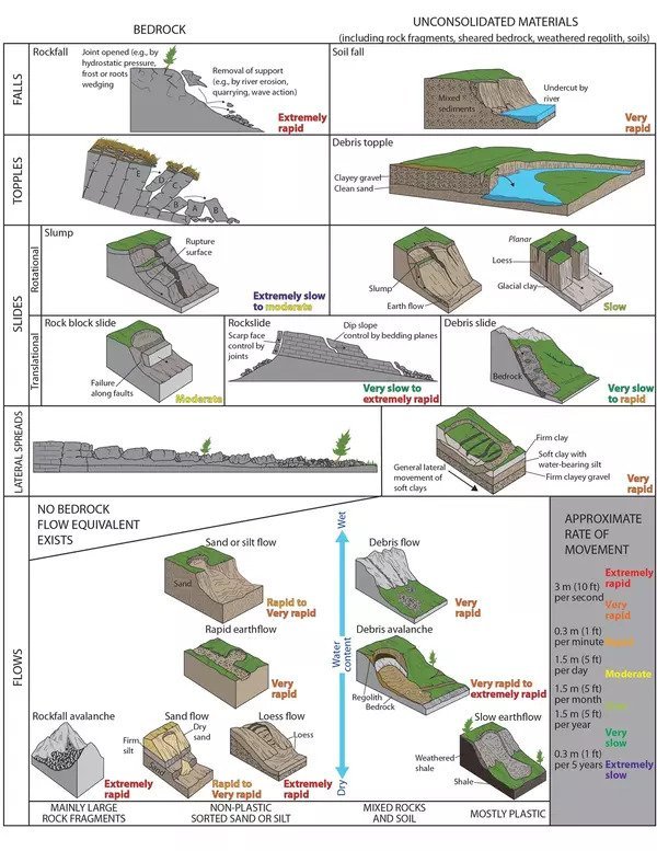
Devils Tower is also affected by the processes of weathering and erosion that continue to erode the sedimentary rocks that surround the towers base. Cracks along the columns are subject to erosion by water and ice. Portions or even entire columns of rock at Devils Tower are breaking off and falling (though at a very slow rate) and the piles of rock that you see in front of you is referred to as scree. One thing worth noting though is that the huge pile of scree indicates that the tower was once much wider. Mass wasting is the movement of rock and soil down slope due to gravity. Examples include rock falls, slumps, and debris flows. Factors such as volume of material, water content, and slope steepness can affect mass wasting. Remember, mass wasting occurs when a slope fails. A slope will fail when it is too steep and as a result is unstable for existing materials. Two factors that can affect slope stability are the slope angle and the strength of the underlying material. We will mostly focus on the slope angle. The steepest angle at which rock and soil material are stable and will not move downslope is called the angle of repose. It is measured relative to the horizontal axis.
Please remain on the trail at all times to hep preserve the site for future generations to enjoy.
Logging Requirements:
- Describe the slope visible in front of you. What form of mass wasting is most dominant here and what is the approximate rate of movement? Relatively speaking, would you say mass wasting occurs frequently here, or more sporadically?
- Estimate how far away you are from the base of Devils Tower. This is a good approximation for how much wider this side of Devils Tower once was.
- Estimate the angle of repose. What factors that are visible in front of you do you think can influence the angle of repose?
- Upload a photo with Devils Tower. You do not need to be in the photo though it is strongly encouraged.
Sources
https://www.nps.gov/subjects/geology/arid-landforms.htm