

Welcome to Pegia beach in Paphos district.
We spent a nice short vacation in this beautiful country and also in this city.
We were thrilled, among many other great things, the old city, the archeology and the beach.
This has brought me to the idea here an EC to this topic.
So I hope to be able to offer here an instructive EC that makes you fun.
Here now general information about this coastal area in the Mediterranean Sea
Pegia (also Pegeia or Peyia, Greek Πέγεια) is a small town in western Cyprus, about 12 km north of Paphos. The town center is located in a basin surrounded by mountainous land and extends towards the coast to the beach of Coral Bay and the small fishing port of Agios Georgios Pegeias.
You are here on a beautiful public sandy beach.
Here you can stay well and relax.
There is also a lot of gastronomy nearby.
But here at this EC it's all about what you're standing on right now, the sand!
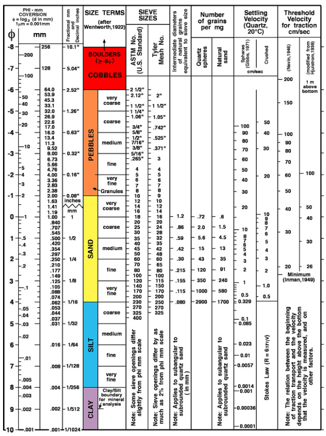
Grain size
Grain size is the equivalent diameter of particles (grains) of clastic sediments (products of weathering and mechanical rearrangement) and soil particles. The particle size classification according to DIN 4022 distinguishes between clay, silt, sand, gravel and stones. The grain size classification according to Udden & Wenthworth, modified after Doeglas, includes clay, silt, sand, granules, pebbles, cobbles and boulders. Both of the above scales use millimeters as the unit. An arithmetic scale is the grain size division according to Phi as a logarithmic transformation of the Udden-Wenthworth scale.
where d = grain size in millimeters. Grain sizes can be determined by different methods, such as sieve analysis, sedimentation analysis or optical methods. It should always be borne in mind that when determining from thin sections, only a two-dimensional section is recorded, which can cause considerable problems with more complicated grain shapes. The standard method for determining grain sizes in thin sections is the chordal section method. The following classification according to mean grain size has become widely accepted internationally for terrain analysis: fine-grained: 1 mm, medium-grained: 1-5 mm, coarse-grained >5 mm. In Germany, the grain size classification for crystalline rocks according to Teuscher is also commonly used.
But now to the sand, and its classification
YOUR TASK FOR THE CACHE:
Please go to the place of coordinates on the beach.
Take there with your hands a small sand sample from the surface.
Please only from the surface, because deeper the composition would be different.
Take the sand sample in your hand, compare the composition & individual sizes with the scale.
Describe to me your observations & explain it to me with the values of the scale.
1.) How many types of sediments do you find?
Please sort the sediments according to the Wentworth scale.
2.) Examine each of the sediments very carefully and check which mineral it is.
A.) Monomineral (consisting of only one type of material)
B.) Polyminerals (consisting of several types of material)
3.) Let dry sand trickle through your hands, then pat hands. What feeling remains on the skin?
A) The feeling as if the hands were roughened by sandpaper.
B) The feeling of powdered sugar between the fingers.
C) The feeling of moisture, although the hands were dry before.
Describe in your own words why it is like that.
4.) Create a photo with you/GPS or name tag in front of the stop "Llia Bus Station" for the log.
And, if you want Optionally also a heart in the sand incl. the date.
Sample:

Of course, I am happy about every other posted photo to spark the travel fever.
I wish you a lot of fun with this EC and a nice time in the city & the beach on the Atlantic coast.
Send me your four answers and include the log photos
Then you may log immediately, if the answers are not correct I will contact you.
If I do not receive any answers or the log photo is missing, I will have to delete your logs.
.........................

Willkommen am Strand von Pegia im Bezirk Paphos
Wir verbrachten einen schönen kurz Urlaub in diesem schönen Land und auch in dieser Stadt.
Uns begeisterte, neben vielen tollen Dingen, die alte Stadt, die Archäologie & der Strand.
Das hat mich zu der Idee gebracht hier einen EC zu diesem Thema auszulegen.
So hoffe ich hier einen lehrreichen EC anzubieten zu können der Euch Spaß macht.
Hier nun allgemeine Informationen zu diesem Küstenbereich im Mittelmehr
Pegia (auch Pegeia oder Peyia, griechisch Πέγεια) ist eine Kleinstadt im westlichen Zypern, etwa 12 km nördlich von Paphos. Das Stadtzentrum liegt in einem Talkessel umgeben von Bergland und erstreckt sich in Richtung Küste bis an den Strand von Coral Bay und den kleinen Fischerhafen von Agios Georgios Pegeias.
Ihr befindet Euch hier an einem schönen öffentlichen Sandstrand.
Hier kann man sich gut aufhalten und entspannen.
Es befindet sich auch viel Gastronomie in der Nähe.
Hier bei diesem EC geht es aber um das worauf ihr gerade steht, dem Sand!
Korngröße
Korngröße, bezeichnetden Äquivalentdurchmesser von Teilchen (Körnern) klastischer Sedimente (Produkte von Verwitterung und mechanischer Umlagerung) und Bodenpartikeln.Es werden verschiedene Korngrößeneinteilungen verwendet. Die Korngrößeneinteilung nach DIN 4022 unterscheidet Ton, Schluff (Silt), Sand, Kies und Steine. Die Korngrößeneinteilungnach Udden & Wenthworth, modifiziert nach Doeglas, beinhaltet clay (Ton), silt (Silt), sand (Sand), granules, pebbles, cobbles (Kies) und boulders (Steine). Die beiden genannten Skalen benutzen als Einheit Millimeter. Eine arithmetische Skala ist die Korngrößeneinteilung nach Phi als logarithmische Transformation der Udden-Wenthworth-Skala.
wobei d = Korngröße in Millimetern. Korngrößen können mit unterschiedlichen Methoden bestimmt werden, wie z.B. durch Siebanalyse, Sedimentationsanalysen oder optische Verfahren. Zu bedenken ist stets, daß bei der Bestimmung aus Dünnschliffen nur ein zweidimensionaler Anschnitt erfaßt wird, was bei komplizierteren Kornformen erhebliche Probleme erzeugen kann. Standardverfahren zur Bestimmung von Korngrößen im Dünnschliff ist das Sehnenschnittverfahren. Folgende Einteilung nach der mittleren Korngröße hat sich für die Geländeansprache international weitgehend durchgesetzt: feinkörnig: 1 mm, mittelkörnig: 1-5 mm, grobkörnig >5 mm. In Deutschland auch gebräuchlich ist die Korngrößeneinteilung für Kristallingesteine nach Teuscher.
Doch nun zum Sand und seiner Klassifizierung
EURE AUFGABE ZUM CACHE:
Bitte gehe an den Ort der Koordinaten am Strand.
Nehme dort mit Deinen Händen ein kleine Sandprobe von der Oberfläche.
Bitte nur von der Oberfläche, denn tiefer wäre die Zusammensetzung eine andere.
Nehme die Sandprobe in die Hand, vergleiche die Zusammensetzung & Größen mit der Scala..
Beschreibe mir Deine Beobachtungen & erkläre es mir mit den Werten der Scala.
1.) Wie viele Arten von Sedimenten findest Du?
Sortiere bitte die Sedimente anhand der Wentworth-Skala.
2.) Untersuche jedes der Sedimente sehr genau und prüfe um welches Mineral es sich handelt.
A) Monominerale (bestehend aus nur einer Materialart)
B) Polyminerale (bestehend aus mehreren Materialarten)
3.) Lass trocken Sand durch die Hande rieseln, nun Hände abklopfen. Welches Hautgefühl bleibt ?
A) Das Gefühl als wären die Hande wie von Schleifpapier aufgeraut.
B) Das Gefühl von Puderzucker zwischen den Fingern
C) Das Gefühl von Feuchtigkeit obwohl die Hände vorher trocken waren.
Beschreibe in eigenen Worten warum dieses so ist.
4.) Erstelle für den Log ein Logfoto mit Dir/GPS oder Namenschild vor der Haltestelle "Llia Bus Station",
und wenn Du möchtest Optional auch ein Herz im Sand inkl. Datum.
Beispiel:
Natürlich freuen ich mich über jedes weitere eingestellte Foto um das Reisefieber zu entfachen.
Ich wünsche euch viel Spaß bei diesem EC und einen schöne Zeit an diesem Strand an der Atlantikküste
Schickt mir Eure drei Antworten und stellt das/die Logfoto/s mit ein.
Dann dürft ihr sofort loggen, sollten die Antworten nicht stimmen werde ich mich bei Euch melden.
Sollte ich keine Antworten erhalten oder das Logfoto fehlen, werde ich leider Eure logs löschen müssen.
.........................
Αν θέλετε, μπορείτε να προσθέσετε το πανό στο προφίλ σας.
Wer möchte kann das Banner in sein Profil einbauen.
Whoever wants to can add the banners to their own profile.
Füge dazu folgenden Code in Dein Profil ein: / Just add the following code to your profile:
Προσθέστε τον ακόλουθο κώδικα στο προφίλ σας:
<a href="http://coord.info/GC9Z96C" target="_blank"><img src="https://s3.amazonaws.com/gs-geo-images/97f67702-2bad-4b8a-a7a4-1496ee3c4bfa_l.jpg?rnd=0.8221949" border="0" /></a>
Υπάρχει ένα μικρό τραπέζι για τους τρεις πρώτους που θα το βρουν!
Für die ersten 3 Finder gibt es eine kleine Tabelle! / For the first 3 finders there is a small table!

1.) Grst
2.) treasure hunter 65
3.) BEAU2009

-------------------------------------------------------------------------------------------------------------------------------------------------
Καλώς ήρθατε στην παραλία Πέγεια στην περιοχή της Πάφου.
Περάσαμε όμορφες σύντομες διακοπές σε αυτή την όμορφη χώρα και σε αυτή την πόλη.
Μας γοήτευσαν η παλιά πόλη, η αρχαιολογία και η παραλία.
Αυτό μου έδωσε την ιδέα να βάλω ένα ΕΚ για αυτό το θέμα εδώ.
Ελπίζω λοιπόν να είμαι σε θέση να σας προσφέρω ένα εκπαιδευτικό ΕΚ που θα απολαύσετε.
Ακολουθούν ορισμένες γενικές πληροφορίες σχετικά με αυτή την παράκτια περιοχή στη Μεσόγειο Θάλασσα.
Η Πέγεια (επίσης Πέγεια ή Πέγεια) είναι μια μικρή πόλη στη δυτική Κύπρο, περίπου 12 χιλιόμετρα βόρεια της Πάφου. Το κέντρο της πόλης βρίσκεται σε μια λεκάνη που περιβάλλεται από βουνά και εκτείνεται προς την ακτή μέχρι την παραλία του Κόλπου των Κοραλλιών και το μικρό αλιευτικό λιμάνι του Αγίου Γεωργίου Πέγειας.
Θα βρεθείτε σε μια όμορφη δημόσια αμμώδη παραλία.
Αυτό είναι ένα καλό μέρος για να μείνετε και να χαλαρώσετε.
Υπάρχει επίσης πολλή γαστρονομία σε κοντινή απόσταση.
Εδώ σε αυτό το ΕΚ, όμως, όλα έχουν να κάνουν με αυτό που στέκεσαι, την άμμο!
Μέγεθος κόκκων
Μέγεθος κόκκων, η ισοδύναμη διάμετρος των σωματιδίων (κόκκων) των κλαστικών ιζημάτων (προϊόντα αποσάθρωσης και μηχανικής αναδιάταξης) και των εδαφικών σωματιδίων. Η ταξινόμηση μεγέθους κόκκων σύμφωνα με το DIN 4022 διακρίνει μεταξύ αργίλου, ιλύος, άμμου, χαλικιού και λίθων. Η ταξινόμηση του μεγέθους των κόκκων σύμφωνα με τους Udden & Wenthworth, τροποποιημένη μετά τον Doeglas, περιλαμβάνει άργιλο, ιλύ, άμμο, κόκκους, βότσαλα, κροκάλες και ογκόλιθους. Οι δύο αναφερόμενες κλίμακες χρησιμοποιούν ως μονάδα τα χιλιοστά. Μια αριθμητική κλίμακα είναι η διαίρεση του μεγέθους των κόκκων σύμφωνα με το Phi ως λογαριθμικός μετασχηματισμός της κλίμακας Udden-Wenthworth.
όπου d = μέγεθος κόκκων σε χιλιοστά. Τα μεγέθη των κόκκων μπορούν να προσδιοριστούν με διάφορες μεθόδους, όπως η ανάλυση με κόσκινα, η ανάλυση καθίζησης ή οι οπτικές μέθοδοι. Θα πρέπει πάντα να λαμβάνεται υπόψη ότι κατά τον προσδιορισμό από λεπτές τομές, καταγράφεται μόνο μια δισδιάστατη τομή, γεγονός που μπορεί να προκαλέσει σημαντικά προβλήματα με πιο περίπλοκα σχήματα κόκκων. Η συνήθης μέθοδος για τον προσδιορισμό των μεγεθών των κόκκων σε λεπτές τομές είναι η μέθοδος της χορδής. Η ακόλουθη ταξινόμηση σύμφωνα με το μέσο μέγεθος των κόκκων έχει γίνει διεθνώς αποδεκτή για την ανάλυση του εδάφους: λεπτόκοκκο: 1 mm, μεσόκοκκο: 1-5 mm, χονδρόκοκκο >5 mm. Στη Γερμανία χρησιμοποιείται επίσης συνήθως η ταξινόμηση μεγέθους κόκκων για τα κρυσταλλικά πετρώματα σύμφωνα με τον Teuscher.
Αλλά τώρα στην άμμο και την ταξινόμησή της
ΤΗΝ ΕΡΓΑΣΊΑ ΣΑΣ ΓΙΑ ΤΗΝ ΚΡΥΦΉ ΜΝΉΜΗ:
Παρακαλείστε να μεταβείτε στην τοποθεσία των συντεταγμένων στην παραλία.
Πάρτε ένα μικρό δείγμα άμμου από την επιφάνεια με τα χέρια σας.
Παρακαλώ μόνο από την επιφάνεια, γιατί βαθύτερα η σύνθεση θα ήταν διαφορετική.
Πάρτε το δείγμα άμμου στο χέρι σας και συγκρίνετε τη σύνθεση και τα επιμέρους μεγέθη με την κλίμακα.
Περιγράψτε μου τις παρατηρήσεις σας και εξηγήστε μου τις με τις τιμές της κλίμακας.
1) Πόσα είδη ιζημάτων μπορείτε να βρείτε;
Ταξινομήστε τα ιζήματα σύμφωνα με την κλίμακα Wentworth.
2) Εξετάστε πολύ προσεκτικά κάθε ένα από τα ιζήματα και ελέγξτε ποιο ορυκτό είναι.
Α) Μονομερή (που αποτελούνται από ένα μόνο είδος υλικού).
Β) Πολυμερή (που αποτελούνται από διάφορα είδη υλικών).
3) Αφήστε τη στεγνή άμμο να κυλήσει μέσα από τα χέρια σας, και τώρα χτυπήστε τα χέρια σας. Ποια αίσθηση του δέρματος παραμένει ?
Α) Η αίσθηση ότι τα χέρια είναι τραχιά από γυαλόχαρτο.
Β) Η αίσθηση της ζάχαρης άχνη ανάμεσα στα δάχτυλα.
Γ) Η αίσθηση της υγρασίας, παρόλο που τα χέρια ήταν στεγνά πριν.
Περιγράψτε με δικά σας λόγια γιατί συμβαίνει αυτό.
4) Δημιουργήστε μια φωτογραφία ημερολογίου για το ημερολόγιο με εσάς/GPS ή την ετικέτα ονόματος μπροστά από τη στάση "Σταθμός Λεωφορείων Llia",
και αν θέλετε προαιρετικά και μια καρδιά στην άμμο με ημερομηνία.
Παράδειγμα:
Ελπίζω να απολαύσετε αυτό το ΕΚ και να περάσετε καλά σε αυτή την παραλία στην ακτή του Ατλαντικού.
Ελπίζω να απολαύσετε αυτό το ΕΚ και να περάσετε καλά σε αυτή την παραλία στην ακτή του Ατλαντικού.
Στείλτε μου τις τρεις απαντήσεις σας και συμπεριλάβετε τη φωτογραφία(ες) του ημερολογίου.
Στη συνέχεια, μπορείτε να συνδεθείτε αμέσως, εάν οι απαντήσεις δεν είναι σωστές θα επικοινωνήσω μαζί σας.
Αν δεν λάβω καμία απάντηση ή αν λείπει η φωτογραφία του ημερολογίου, θα πρέπει δυστυχώς να διαγράψω τα αρχεία καταγραφής σας.