Notice: "Cache seekers assume all risks and responsibilities involved in seeking this earthcache."
Warning: This is an agricultural area where many long-haul trucks full of wheat, corn, onions, potatoes, carrots, sugar beets and other commodities are busy going down the road. Most of us locals are accustomed to these trucks. If you don’t feel safe or comfortable stopping alongside the road or in a pullout to observe the geology, “Don’t Stop”. Don’t let earthcaching control you, but rather you control earthcaching. “Just because it is there, doesn’t mean you have to stop!”
“For your safety, even though the shoulder may be wide enough to stop and make observations, please park in the designated parking pullout and walk to the final. The road does get busy at times. If you feel uncomfortable with the suggested parking location, find a wider spot down the road and walk back.”
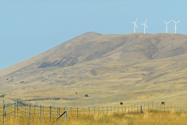
View of Haystack Butte looking west from Stonehenge WW1 Memorial
Haystack Butte is a Columbia Hills Anticline (arched shaped fold) and part of the Yakima Fold Belt Structure. The butte consist mostly of Grand Ronde Basalt. These lava floods were laid down 15.6-16.7 million years ago. Laid on top of the Grand Ronde are several individual flows of the Wanapum formation laid down 14-15.6 million years ago. Soon after the basalt layers were laid down, the uplift of the Columbia Hills began. Where Washington County Road 14 travels below the butte, the road parallels a thrust fault zone between 700-800 feet in elevation. The fault has been confirmed, but its location is just inferred. A break in the layered basalt occurred when horizontal tectonic pressure from the south pushed north. The pressure here became so great that something had to give. The break in the basalt created an up lift of the northern portion of the Wanapum formation. The northern portion of the formation was pushed upwards to some 2,900 feet leaving the southern portion at 700 feet. The southern plate is now pushing under the northern fault scarp.
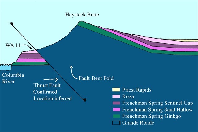
Geological Cross Section of Haystack Butte and the Columbia Hills looking west (Not to scale)
This cross section was created using USGS trop map (v2.0 2022) and Danielle Wordring geological map of Stacker Butte (June 10, 2020). The cross section is for explanation purposes only and is not to scale.
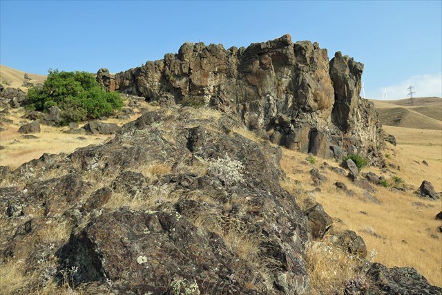
Haystack Butte Lava Flow on Washington County Road 14 at Devil Gate Canyon
Haystack Butte is a cinder cone volcano. The origin of the lava is from the Simcoe Mountains Volcanic Fields. The field encompasses an area from the Columbia River on its south, through Goldendale and the Yakima Indian Reservation on its north. 900,000 years ago, Haystack volcano was active spewing out molten lava mostly down its southern slopes, over Devil Gate Canyon, into the Columbia River and across Miller Island. The flow area was not extensive. Some of the lava was washed away with the ice age flood 12-15,000 years ago. The flood was another 400 feet above the WA 14 road pullout where the lava flow is still visible.
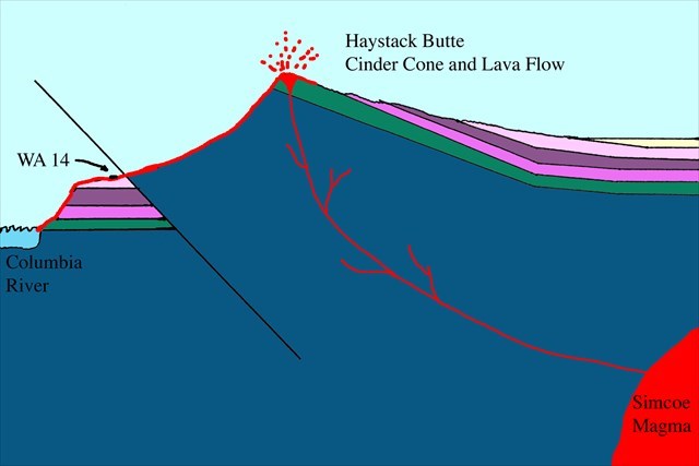
Haystack Butte Cinder Cone Volcano and Lava Flow (Not to scale)
Cinder cones are the simplest and most common form of volcanos. Cinder are small hot molten rocks that splatter in all directions. Examples of cinder cone volcanos are Hawaii’s Mauna Kea and Sicily’s Mount Etna.
To log this Earthcache; Please send a private message to me with answers to the following questions.
1. What is a thrust fault?
2. Haystack Butte Cinder Cone is part of what volcanic field?
3. Looking southwest down Devil Gate Canyon through the telephone poles, you will see the top portion and cliff face of the Frenchman Spring Sand Hollow basalt flow that is part of Miller Island. Compare and contrast the escarpment of the Haystack Butte lava flow at the final with that of the Sand Hollow flow.
Optional: You may upload a photo to the page of any local wildlife, unique vegetation or geology in the area.
Additional study and sources:
Video: Stonehenge Pop-Up (includes Haystack Butte)
Kinematics of the Columbia Hills Anticline and the Warwick Strike-Slip Fault, Yakima Fold and Thrust Belt, Washington, USA
Haystack Butte Lava Flow part of The Simcoe Volcanic Field
Geologic Map of the Simcoe Mountains Volcanic Field, Main Central Segment, Yakama Nation, Washington