Skip to content

Cabo Trafalgar EarthCache

Hidden : 11/14/2022
Difficulty:
1.5 out of 5
Terrain:
2 out of 5

Size: Size:   other (other)

Join now to view geocache location details. It's free!

Watch

How Geocaching Works

Please note Use of geocaching.com services is subject to the terms and conditions in our disclaimer.

Geocache Description:


Cabo de Trafalgar


Español

Para registrar este earthcache, enviame um correo eletrónico com la respuesta a las seguintes preguntas:

1) ¿Que tipo de tombolo es del Trafalgar? ¿Cuales son los dos procesos que originan un tombolo?

2) En WP1 ( Rocas), es posible visualizar varias rocas, describelas. ( Color, textura, altura del suelo, brillo, tamaño grano )

3) ¿Que tipo de rocas forman la base de la isla? ¿Cual es su edad?

4)Añade una fotografia tuya en el local, u otra en la que se pueda ver algún objeto, o tu nick en un papel

-Si crees que as concluido con exito los objetivos de este Earth Cache, y me ha enviado todas las respuestas solicitadas, puede hacer el log. Luego yo comprobaré que son correctas, y si hay cualquier problema me pondre en contacto para arreglarlo.
-Logs sin respuestas enviadas previamente, seran borrados sin aviso

Localización


Cerca de Caños de Meca, se encuentra este monumento, en los dominios del Faro del Cabo de Trafalgar. Su bello paisaje mezcla dunas de fina arena, extensas playas y una zona rocosa sobre la que se asienta el faro.
La arena arrastrada por mareas creó un doble tómbolo o lengua que unieron el islote con la costa, encerrando una depresión encharcada por la lluvia. Al retirarse el mar, el viento originó sistemas dunares en las playas al sur del islote, contribuyendo a su fosilización. En la antigua costa, el levante desarrolló otro sistema dunar, hoy cubierto de sabinas y lentiscos.
Las flores del alhelí de mar, azucena marina y cardo de mar, forman un manto colorido sobre las arenas. Estas cubiertas de barrones y gramíneas, que fijan el sustrato, amparan al tártago marino. En zonas estabilizadas aparecen rubias y cuernecillos de mar, artemisias y clavellinas.
En la zona inundable crecen los juncos, convirtiéndose en posadero habitual de aves como la gaviota de Audouín, el andarrío bastardo, el charrán patinegro, la pagaza piquirroja y la aguja colipinta, además de la garceta. Las playas albergan cañadillas, coñetas y la llamativa estrella de arena anaranjada.
Pero lo más característico del lugar es su historia. Alrededor del faro, existen yacimientos arqueológicos, como un templo romano del dios Juno con altar sacrificial y una factoría de salazones. Del asentamiento hispano-musulmán se conserva parte de una torre vigía del s.IX, desmantelada en el XIX para edificar el actual faro. Sin embargo, el acontecimiento que lo hace famoso es la Batalla de Trafalgar, ocurrida en 1805, con la trágica muerte de 5.000 soldados, el hundimiento de innumerables barcos y la pérdida de la hegemonía naval española ante la Armada británica

Tombolos

Un tómbolo (del italiano tombolo) es un accidente geográfico sedimentario, como por ejemplo una barra, que forma una estrecha lengua de tierra entre una isla o una gran roca alejada de la costa y tierra firme, o entre dos islas o grandes rocas. Ejemplos de tómbolos son el peñón de Ifach, el istmo arenoso que une el peñón de Gibraltar con el continente, el que une Peñíscola con tierra firme,​ o el existente en el cabo Trafalgar.

¿ Como se forman?

Por deriva continental: Esta deriva litoral tiene lugar cuando las olas van empujando el sedimento. Este sedimentos puede estar compuesto o de arena, limo y arcilla. Este sedimentos se va acumulando entre la playa y la isla creando una zona de acumulación que se puede ver como sea la isla estuviera atada al continente. La deriva litoral depende de la dirección del viento. Para que se forme de una forma continua la dirección del viento tienen que ser hacia una dirección predominante. De lo contrario, no podrá acumular se tanto sedimentos en la misma dirección.

Por difracción de onda:
A veces, si estas formaciones se dan por la deriva litoral no se considera un verdadero tómbolo. Un verdadero tómbolo es el que está formado por la difracción de onda y de fracción de las olas. Las obras siguen una dinámica gobernada por la fuerza y dirección del viento. Estas colas se dirigen hacia la costa y se va ralentizando conforme van avanzando por aguas menos profundas. Esta ralentización se debe al roce de las ondas con el suelo. Esta fuerza de rozamiento va disminuyendo la velocidad con la que la ola se desplaza hasta tal punto que rompen, cuando llega a las islas están cercanas a la costa, debido a que las ondas van moviéndose a un ritmo más lento de lo normal, se desplazan alrededor de la isla en lugar de sobre ella. Conforme el agua se mueve más lentamente alrededor de la isla, va recogiendo los sedimentos a lo largo del camino. Los sedimentos se van depositando y continúan acumulándose hasta crear la barra de arena que conecta la isla con la plan. Evidentemente, esto o es un proceso muy largo en el tiempo.

Difracción

El Cabo de Trafalgar es un doble tómbolo
de alrededor de 1 km de longitud localizado entre Conil y Barbate. La isla rocosa, de unos 20 m de altura, está constituida por un nivel basal de playa cuaternaria formado por conglomerados y areniscas, datado en 107.000 años y ubicado en torno al nivel medio del mar actual. El depósito aparece fosilizado por una duna fósil o eolianita muy laminada, que forma el cuerpo principal de la isla. El borde SE del Cabo está limitado por una plataforma rocosa de unos 100 m de anchura modelada sobre la playa cuaternaria. La isla está conectada con tierra por dos barreras arenosas y una zona lacustre intermedia, actualmente semicolmatada con sedimentos finos


English


To log this earthcache, send me an email with the answer to the following questions:

1) What kind of tombolo is from Trafalgar? What are the two processes that cause a tombolo?

2) At WP1 ( Rocks), it is possible to visualize several rocks, describe them. ( Color, texture, height from the ground, brightness, grain size )

3) What kind of rocks form the base of the island? How old are you?

4) Add a photograph of yourself in the local, or another in which an object can be seen, or your nick on a piece of paper
 

-If you think you have successfully completed the objectives of this Earth Cache, and you have sent me all the requested responses, you can log. Then I will check that they are correct, and if there is any problem I will contact you to fix it.
-Logs without responses previously sent, will be deleted without notice

Location


Near Caños de Meca, is this monument, in the domains of the Cape Trafalgar Lighthouse. Its beautiful landscape mixes fine sand dunes, extensive beaches and a rocky area on which the lighthouse sits.
The sand carried by tides created a double tombolo or tongue that joined the islet with the coast, enclosing a depression flooded by rain. As the sea receded, the wind created dune systems on the beaches to the south of the islet, contributing to its fossilization. On the old coast, the east developed another dune system, today covered with junipers and mastics.
The flowers of the sea wallflower, sea lily and sea thistle form a colorful blanket over the sands. These covers of grass and grass, which fix the substrate, protect the marine spurge. In stabilized areas appear rubies and sea horns, artemisias and pinks.
Reeds grow in the flooded area, becoming a regular perch for birds such as Audouin's gull, the common sandpiper, the lesser tern, the red-billed pagaza and the black-tailed marlin, as well as the little egret. The beaches are home to cañadillas, coñetas and the striking orange sand star.
But the most characteristic of the place is its history. Around the lighthouse, there are archaeological sites, such as a Roman temple of the god Juno with a sacrificial altar and a salted fish factory. From the Spanish-Muslim settlement, part of a watchtower from the 9th century is preserved, dismantled in the 19th century to build the current lighthouse. However, the event that makes it famous is the Battle of Trafalgar, which occurred in 1805, with the tragic death of 5,000 soldiers, the sinking of countless ships and the loss of Spanish naval hegemony to the British Navy.

Tombolos

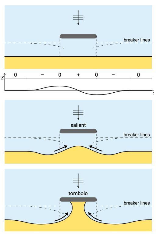
A tombolo (from Italian tombolo) is a sedimentary landform, such as a bar, that forms a narrow neck of land between an island or a large rock far from the coast and the mainland, or between two islands or large rocks. Examples of tombolos are the Peñón de Ifach, the sandy isthmus that joins the Rock of Gibraltar with the mainland, the one that joins Peñíscola with the mainland, or the one existing at Cape Trafalgar.


How are they formed?

Due to continental drift: This coastal drift occurs when the waves push the sediment. This sediment may be composed of sand, silt, and clay. This sediment accumulates between the beach and the island, creating an accumulation zone that can be seen as the island is tied to the mainland. Longshore drift depends on wind direction. For it to form continuously, the direction of the wind must be towards a predominant direction. Otherwise, you won't be able to accumulate as much sediment in the same direction.

By wave diffraction: Sometimes, if these formations occur due to coastal drift, it is not considered a true tombolo. A true tombolo is the one formed by wave diffraction and wave fraction. The works follow a dynamic governed by the strength and direction of the wind. These tails head towards the coast and slow down as they move through shallower waters. This slowdown is due to the friction of the waves with the ground. This force of friction decreases the speed with which the wave travels to such an extent that it breaks. When it reaches the islands, they are close to the coast, due to the fact that the waves move at a slower rate than normal, they move around the island instead of on it. As the water moves more slowly around the island, it picks up sediment along the way. The sediments are deposited and continue to accumulate until they create the sand bar that connects the island with the plan. Obviously, this or it is a very long process in time.


Difracción

Cabo de Trafalgar is a double tombolo about 1 km long located between Conil and Barbate. The rocky island, about 20 m high, is made up of a quaternary beach basal level made up of conglomerates and sandstones, dated to 107,000 years and located around the current mean sea level. The deposit appears fossilized by a highly laminated fossil or eolianite dune, which forms the main body of the island. The SE edge of the Cape is limited by a rocky platform about 100 m wide modeled on the Quaternary beach. The island is connected to land by two sandy barriers and an intermediate lake area, currently semi-filled with fine sediments.


Fuentes:

Geolodía Cadiz 2011

Meteorologiaenred


Additional Hints (No hints available.)