Stratigraphy
in Bahrain
Stratigraphy
Stratigraphy is a branch of geology, a scientific discipline
concerned with the description of rock successions and their
interpretation in terms of general time scale. It provides a basis for
historical geology, and its principles and methods have found
application in such fields as petroleum geology and archaeology.
Stratigraphic studies deal primarily with sedimentary rocks but may
also encompass layered igneous lava rocks or metamorphic rocks formed
either from extrusive igneous material or from sedimentary rocks.
Because oil and natural gas almost always occur in stratified
sedimentary rocks, the process of locating petroleum reservoir traps
has been facilitated significantly by the use of stratigraphic concepts
and data.
As a branch of historical geology, stratigraphy is the basis for
reconstructing the history of the earth and the history of life on
earth. But it also often serves to solve general geological questions.
In the 19th century it was recognized that this method could also be
applied to other strata, including the elements contained in them.
Stratigraphy was thus also transferred to archaeology.
Nicolas Steno established the theoretical basis for stratigraphy when
he introduced the law of superposition in 1669 - the principle that in
any undisturbed deposit the oldest layers are normally located at the
lowest level. Accordingly, in archaelogy it is presumed that
the
remains of each succeeding generation are left on the debris of the
last. However,
tectonic processes, unusual deposits and intrusions can break this rule
in some cases.
Stratigraphy has some related subfields, the most significant among
them are lithostratigraphy (lithologic stratigraphy), biostratigraphy
(biologic stratigraphy), and chronostratigraphy (stratigraphy by age).
Variation in rock units, most obviously displayed as visible layering,
is due to physical contrasts in rock type. This variation can occur
vertically as layering (bedding), or laterally, and reflects changes in
environments of deposition, known as facies change. This variations
provide a lithostratigrapy of the rock unit. Key concepts in
stratigraphy involve understanding how certain geometric relationships
between rock layers arise and what these geometries imply about their
original depositional environment. The basic concept in stratigraphy
(as already mentioned), called the law of superposition,
states: in an undeformed stratigraphic sequence, the oldest strata
occur at the base of the sequence.
Biostratigraphy or paleontologic stratigraphy is based on fossil
evidence in the rock layers. Strata from widespread locations
containing the same fossil fauna and flora are said to be correlatable
in time. Biostratigraphy was one of the first and most powerful lines
of evidence for biological evolution. It provides strong evidence for
the formation and extinction of species. Stratigraphy is also commonly
used to delineate the nature and extent of hydrocarbon-bearing
reservoir rocks, seals, and traps of petroleum geology.
Chronostratigraphy is the branch of stratigraphy that places an
absolute age, rather than a relative age on rock strata. The branch is
concerned with deriving geochronological data for rock units, both
directly and interferentially, so that a sequence of time-relative
events that created the rock formation can be derived.
A gap or missing strata in the geological record of an area is called a
stratigraphic hiatus. This may be the result of a halt in the
deposition of sediment or alternatively the gap may be due to removal
by erosion of the material which is missing. Thus a gap may represent
both a period of non-deposition and a period of erosion.
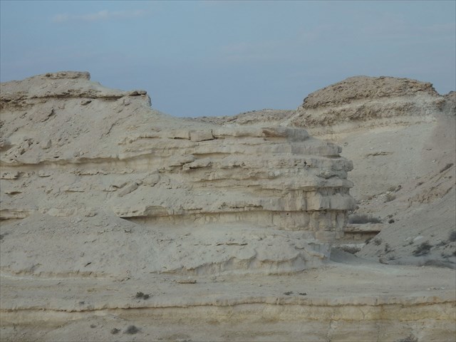
Stratigraphic situation at the location
The biggest part of the Bahrain Peninsula is covered by
extensive sedimentary
formations dating from the Eocene (Cenozoic) to the present day. The
present rock strata show that the Eocene in Bahrain was characterized
by shallow sea conditions. Apart from the anticline, Bahrain has few
tectonic compression features, which means stratgraphically that the
layers are mostly as they were originally deposited.
Most rocks that outcrop on the surface on Bahrain Peninsula date to the
Eocene in the Cenozoic. The rimrock of Eocene limestone forms a ring
around the main peninsula, with cliffs up to 30,5 meters tall and wind
erosion features are common. An angular unconformity separates middle
Eocene rocks from sandier Miocene rocks.
At the location where the Earthcache was created, you can see the
layers of the deposits particularly well. This makes the place an
excellent example of stratigraphic considerations.
Your task to log the
cache:
Answer the following questions via message (not mail!) in English or
German via my geocaching profile:
1.) Take a closer look at he layers - does the so-called law of
superposition apply here? Why? Give me an explanation in your own words!
2.) How thick are the layers on site? Which colorings, granulations can
you see?
3.) Why do you think that there are sometimes thinner and sometimes
thicker layers?
4.) Optional: Post a photo with your log, showing you and/or your GPS
near the location!
After you've sent me the message
with your answers, feel free to log! Only if there's something wrong,
I'll contact you via message!
Sources:
Chapman, R. E. (1983): Petroleum Geology. In: Elsevier Scientific,
Amsterdam.
de.wikibrief.org
Franke, H. (1969): Methoden der Geochronologie.
Press, F. & R. Siever (1995): Allgemeine Geologie.
wikipedia.org
Willis, R. P. (1963): Geology of the Arabian Peninsula: Bahrain.
www.britannica.com
www.stratigraphy.org
The pictures were taken by the author.
Enjoy the location!
 The
most exciting way to learn about the Earth and its processes is to get
into the outdoors and experience it first-hand. Visiting an Earthcache
is a great outdoor activity the whole family can enjoy. An Earthcache
is a special place that people can visit to learn about a unique
geoscience feature or aspect of our Earth. Earthcaches include a set of
educational notes and the details about where to find the location
(latitude and longitude). Visitors to Earthcaches can see how our
planet has been shaped by geological processes, how we manage the
resources and how scientists gather evidence to learn about the Earth.
To find out more click HERE.
The
most exciting way to learn about the Earth and its processes is to get
into the outdoors and experience it first-hand. Visiting an Earthcache
is a great outdoor activity the whole family can enjoy. An Earthcache
is a special place that people can visit to learn about a unique
geoscience feature or aspect of our Earth. Earthcaches include a set of
educational notes and the details about where to find the location
(latitude and longitude). Visitors to Earthcaches can see how our
planet has been shaped by geological processes, how we manage the
resources and how scientists gather evidence to learn about the Earth.
To find out more click HERE.