Skip to content

Cerro testigo de Castrojeriz EarthCache

Hidden : 1/3/2023
Difficulty:
2 out of 5
Terrain:
2 out of 5

Size: Size:   other (other)

Join now to view geocache location details. It's free!

Watch

How Geocaching Works

Please note Use of geocaching.com services is subject to the terms and conditions in our disclaimer.

Geocache Description:


Cerro testigo de Castrojeriz


Español


Para registrar este earthcache, enviame un mensage o correo eletrónico com la respuesta a las seguintes preguntas:

1) Despues de visitar las coordendas del cache, y WP2, indica cuales son las principales diferencias que puedes observar entre ambos lugares. ( Color, textura, se pueden ver estratos o no)

2) Define muy brevemente con tus palabras que es un cerro testigo, y por que son importantes geologicamente hablando

3) ¿Que tipo de rocas forman la parte superior del cerro de Castrojeriz ? ¿Son mas duras o mas blandas que las que forman la base del cerro ?

4) Añade una fotografia tuya en el lugar, u otra en la que se pueda ver algún objeto, o tu nick en un papel

-Si crees que as concluido con exito los objetivos de este Earth Cache, y me ha enviado todas las respuestas solicitadas, puede hacer el log. Luego yo comprobaré que son correctas, y si hay cualquier problema me pondre en contacto para arreglarlo.
-Logs sin respuestas enviadas previamente, seran borrados sin aviso

Localización


El castillo de Castrojeriz se localiza en el extremo oriental de un destacado cerro testigo, situado en la margen izquierda del río Odra, delimitado al S por el arroyo de Villajos. Presenta plataforma amesetada de planta triangular más estrecha al E y laderas muy pronunciadas con un aterrazamiento artificial en la zona superior.

Se trata de un emplazamiento con un marcado carácter estratégico por su fácil defensa y amplio campo de control visual. Los suelos son de matriz arcillo-arenosa. Este territorio se integra en la unidad morfoestructural "Páramos calcáreos" caracterizada por los páramos pontienses del Arlanzón, eje hidrográfico que jerarquiza una amplia red de ríos secundarios destacando el Arlanza.

El relieve está configurado por una superficie superior ondulada que se une con la campiña a través de laderas abruptas; si bien, en ausencia de las calizas pontienses el relieve se caracteriza por una serie de hombreras similares a los páramos pero de laderas más suaves. Esto determina un uso del suelo para labores agrícolas -cultivos de secano en las zonas altas y de regadío en la vega del Arlanzón- y ganaderas -pastizales de escasa calidad en los bordes y laderas de los páramos.

El cerro tuvo diversas fases de ocupación identificándose en el área restos constructivos del castillo pero también documentándose algunos fragmentos de cerámica a mano de pastas oscuras y cocción reductora; otros realizados a torno que presentan una mayor variedad de pastas y cocciones, identificándose producciones celtibéricas y cerámica común y de tipo cocina posiblemente romanas.
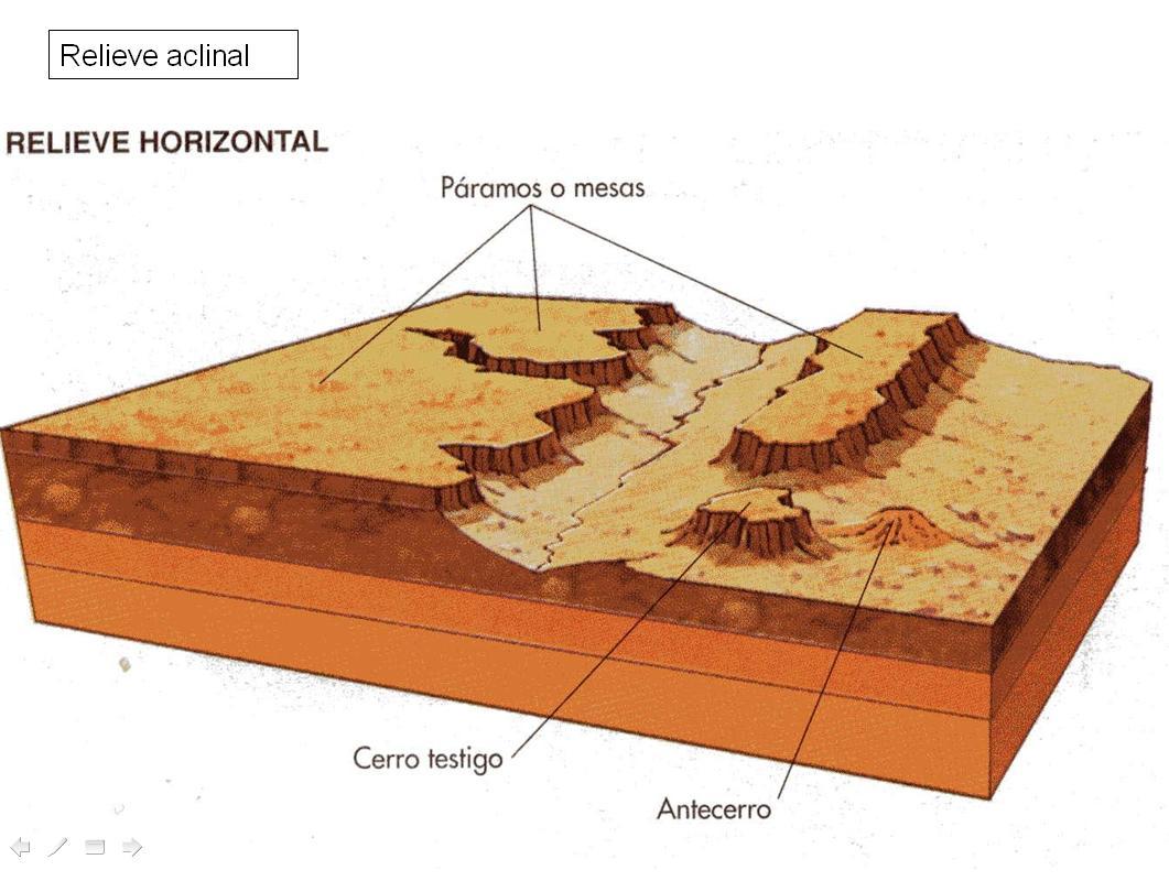
Cerro testigo

Un cerro testigo u otero son aquellos relieves que se encuentran aislados en un territorio llano. En consecuencia, consiste en un relieve residual que ha sido esculpido por el desgaste producido como consecuencia de la erosión.


Este fenómeno natural funciona como una especie de testimonio tanto de la evolución como del retroceso de una plataforma o de una cuesta. Se trata de un cerro producto de un resto proveniente de una antigua plataforma; dicho fenómeno aparece en un relieve donde se pueden encontrar capas de rocas blandas y duras localizadas horizontalmente.

Esto quiere decir que el paisaje de este tipo de cerro posee unas líneas horizontales que lo distinguen entre los demás relieves. Además, al aumentar el proceso de erosión —generalmente producida por los ríos— se van formando colinas. Esto puede ocasionar que un territorio esté colmado por varios cerros testigo que tengan una cumbre plana.

En otras palabras, se conoce como cerros testigo a estos relieves ya que han quedado como testigos de la plataforma que existió en ese territorio millones de años atrás, y que fue modificándose en el transcurso del tiempo mediante la erosión producida por el agua.

Un cerro testigo también se puede definir como una especie de colina cuya cima es plana rodeada por un notable acantilado, que finaliza extendiéndose en una amplia llanura. En ocasiones se puede emplear el término para referirse a un relieve que consta de una elevación mayor a la de una colina, pero no es tan alto como para denominarlo montaña.

Por ejemplo, en algunas regiones de los Estados Unidos se pueden contemplar unas colinas que constan de una cima plana y de líneas horizontales; sin embargo, no se puede afirmar que estos relieves son cerros testigo porque estos suelen ser de menor tamaño. Eso sí, ambas formaciones son producto de la erosión.

Características

Los cerros testigo pueden ser catalogados como “montes islas” y se caracterizan por haber sido preservados de la erosión, que ha desmantelado el resto de los materiales aledaños. Los montes isla se han mantenido protegidos gracias a una litología más resistente (rocas duras) que aparece en la cima.

Estos cerros también se caracterizan por ser muy útiles para los estudios de geología, puesto que son los únicos relictos que pertenecieron a unas formaciones geológicas que anteriormente recubrían una región y que fueron desplazadas por los agentes erosivos. Este proceso de eliminación “erosión-sedimentación” es propio de la geodinámica externa.

Así mismo, los cerros testigo se caracterizan por haber estado rodeados de agua, por lo que suelen estar ubicados cerca de ríos que dan una salida al océano. Según algunos estudiosos, estos relieves debieron haberse formado entre la edad Mioceno inferior y la Inferior media, teniendo en cuenta una cronología geomorfológica.

Algunos conocedores han establecido que, generalmente, estos relieves cuentan con una localización que posee una formación de edad finipaleógena, teniendo un fuerte carácter arcósico.

Esta formación no suele estar recubierta de sedimentos rojos, pues estos se presentan en la sedimentación miocena. De encontrarse estos vestigios rojizos, sería solo por los primeros tres o cuatro metros del cerro.

Diferencia con páramo

Los cerros testigo se diferencian de los páramos o mesas principalmente por las dimensiones de tamaño, ya que las mesas suelen extenderse a lo largo del territorio y son mucho más altas. En otras palabras, su principal diferencia es que los cerros testigo o “montes isla” se encuentran solitarios y son mucho más pequeños.

Además, el páramo abarca todo un ecosistema de carácter montano e intertropical, teniendo un predominio de la vegetación arbustiva, lo que lo clasifica en términos biogeográficos como una pradera debido a su tipo de vegetación. En cambio, los cerros testigo se encuentran aislados y, aunque también cuentan con arbustos y matorrales, su vegetación es mucho menor.

Cerro de Castrojeriz


El cerro de Castrojeriz y los pequeños páramos circundantes, son unas de las mejores muestras de cerro testigo o monte isla. Su nombre se debe a que se mantienen elevados sobre el terreno circundante, como testigos de lo que el agua, la nieve, el hielo, el viento y todas las formas de erosión han ido arrastrando durante mucho tiempo a su alrededor. Las calizas de las partes altas son más duras que las capas de terreno o estratos inferiores y actúan como protectoras de lo que hay debajo, a modo de gigantescos paraguas frente a la erosión. Estudiando la gran tarta de pisos (estratos) que forman el cerro de Castrojeriz, podemos analizar cómo se formó esta parte de la cuenca del Duero.

En la cima del cerro de Castrojeriz podrá observar restos fósiles de conchas de pequeños caracoles incrustados en las rocas. Estos moluscos vivían en lugares de agua dulce, lo que le indica que estas rocas se formaron en grandes charcas y lagos del interior de la península, hace millones de años.

El sector de Castrojeriz (Burgos) representa un dominio sedimentario intermedio de la Cuenca Terciaria del Duero entre sus bordes NE y E y la zona central de la misma. En él afloran de forma extensa los materiales de las tres unidades que caracterizan las series miocenas de la cuenca: en la base, lutitas y areniscas pardas y ocres de la FaciesTierra de Campos; en el centre, ocupando la mayor parte de los relieves, las margas y margocalizas con yesos de las Facies Cuestas, y en el techo, las calizas micríticas de los Páramos. Estas series forman en el sector amplios páramos aislados por depósitos cuaternarios formando terrazas y llanuras aluviales del río Arlanzón y de sus abundantes afluentes. Ello ha provocado que, en ocasiones, los depósitos miocenos aparezcan en forma de cerros testigos como el de Castrojeriz, donde afloran extensamente los materiales miocenos. Este cerro testigo es un excelente otero donde reconocer y caracterizar las tres unidades que integran los materiales terciarios miocenos de este sector de la cuenca del Duero


English

To log this earthcache, send me an email with the answer to the following questions:

1) After visiting the cache coordinates, and WP2, indicate which are the main differences that you can observe between both places. (Color, texture, strata can be seen or not)

2) Define very briefly with your words what a witness hill is, and why they are important geologically speaking

3) What kind of rocks form the upper part of the hill of Castrojeriz? Are they harder or softer than those that form the base of the hill?

4) Add a photograph of yourself in the place, or another in which you can see an object, or your nick on a piece of paper


-If you believe you have successfully completed this Earth Cache goals and has already sent to me all the requirements as requested, Please, feel free to log it as found. Later i will verify the requirements sent and, if necessary, contact you in order to make the necessary corrections to your log.

-Logs without responses previously sent, will be deleted without notice

Location


The castle of Castrojeriz is located at the eastern end of an outstanding witness hill, located on the left bank of the Odra River, delimited to the S by the Villajos stream. It presents a plateau platform with a narrower triangular plan to the E and very steep slopes with an artificial terracing in the upper area.

It is a location with a markedly strategic character due to its easy defense and wide field of visual control. The soils are clay-sandy matrix. This territory is integrated into the morphostructural unit "Páramos calcareos" characterized by the Pontian moors of the Arlanzón, a hydrographic axis that hierarchizes a wide network of secondary rivers, highlighting the Arlanza.

The relief is configured by an undulating upper surface that joins the countryside through steep slopes; Although, in the absence of the Pontian limestone, the relief is characterized by a series of shoulder pads similar to the páramos but with gentler slopes. This determines a use of the soil for agricultural work -rainfed crops in the highlands and irrigated land in the Arlanzón plain- and livestock -poor quality pastures on the edges and slopes of the páramos.

The hill had various phases of occupation, identifying construction remains of the castle in the area but also documenting some fragments of hand-made pottery with dark pastes and reducing firing; others made on a lathe that present a greater variety of pastes and firings, identifying Celtiberian productions and common ceramics and possibly Roman kitchen-type ones.

Witness Hill

A witness hill or hillock are those reliefs that are isolated in a flat territory. Consequently, it consists of a residual relief that has been sculpted by the wear produced as a consequence of erosion.


This natural phenomenon works as a kind of testimony of both the evolution and the retreat of a platform or a slope. It is a hill product of a remainder from an old platform; This phenomenon appears in a relief where layers of soft and hard rocks located horizontally can be found.

This means that the landscape of this type of hill has horizontal lines that distinguish it from other reliefs. In addition, as the erosion process increases —generally produced by rivers— hills are formed. This can cause a territory to be filled with several witness hills that have a flat top.

In other words, these reliefs are known as witness hills since they have remained as witnesses of the platform that existed in that territory millions of years ago, and that was modified over time by erosion produced by water.

A witness hill can also be defined as a kind of hill whose top is flat surrounded by a notable cliff, which ends by extending into a wide plain. Sometimes the term can be used to refer to a relief that consists of a higher elevation than a hill, but it is not so high as to call it a mountain.

For example, in some regions of the United States you can see some hills that consist of a flat top and horizontal lines; however, it cannot be affirmed that these reliefs are witness hills because they are usually smaller. Of course, both formations are the product of erosion.

Characteristics

The witness hills can be classified as "island mountains" and are characterized by having been preserved from erosion, which has dismantled the rest of the surrounding materials. The island mountains have remained protected thanks to a more resistant lithology (hard rocks) that appears at the top.

These hills are also characterized for being very useful for geological studies, since they are the only remnants that belonged to geological formations that previously covered a region and were displaced by erosive agents. This elimination process "erosion-sedimentation" is typical of external geodynamics.

Likewise, the witness hills are characterized by having been surrounded by water, which is why they are usually located near rivers that give an outlet to the ocean. According to some scholars, these reliefs must have been formed between the Lower Miocene and Lower Middle ages, taking into account a geomorphological chronology.

Some connoisseurs have established that, generally, these reliefs have a location that has a formation of end-paleogene age, having a strong arcosic character.

This formation is not usually covered by red sediments, as these occur in the Miocene sedimentation. If these reddish vestiges were found, it would only be for the first three or four meters of the hill.

Difference with moor

The witness hills differ from the páramos or mesas mainly due to their size, since the mesas tend to extend throughout the territory and are much higher. In other words, their main difference is that the witness hills or “island mountains” are solitary and much smaller.

In addition, the páramo encompasses an entire ecosystem of a montane and intertropical nature, with a predominance of shrubby vegetation, which classifies it in biogeographical terms as a prairie due to its type of vegetation. On the other hand, the witness hills are isolated and, although they also have shrubs and scrub, their vegetation is much less.

Hill of Castrojeriz


The hill of Castrojeriz and the small surrounding páramos are some of the best examples of the witness hill or island mount. They get their name from the fact that they stand high above the surrounding terrain, bearing witness to what water, snow, ice, wind and all forms of erosion have long washed around them. The limestones of the upper parts are harder than the layers of ground or lower strata and act as protectors of what is below, like gigantic umbrellas against erosion. By studying the large layer of layers (strata) that make up the Castrojeriz hill, we can analyze how this part of the Duero basin was formed.

At the top of the Castrojeriz hill you will be able to see fossil remains of small snail shells embedded in the rocks. These mollusks lived in freshwater places, which tells you that these rocks were formed in large pools and lakes in the interior of the peninsula, millions of years ago.

The Castrojeriz sector (Burgos) represents an intermediate sedimentary domain of the Duero Tertiary Basin between its NE and E borders and its central zone. Materials from the three units that characterize the Miocene series of the basin extensively outcrop in it: at the base, shales and brown and ocher sandstones of the Tierra de Campos Facies; in the center, occupying most of the reliefs, the marl and marl limestone with gypsum from the Facies Cuestas, and on the roof, the micritic limestone from the Páramos. These series form in the sector wide moors isolated by Quaternary deposits forming terraces and alluvial plains of the Arlanzón river and its abundant tributaries. This has caused, on occasions, the Miocene deposits to appear in the form of witness hills such as Castrojeriz, where Miocene materials outcrop extensively. This witness hill is an excellent knoll on which to recognize and characterize the three units that make up the Miocene Tertiary materials of this sector of the Duero basin.


Fuentes:

Patrimonio natural
Adecocamino
Lifeder
Cerro testigo mioceno de Castrojeriz ( Lugar de interes gelógico IGME )
Apuntes geografia

Additional Hints (No hints available.)