Colt State Park is located on the eastern side of Narragansett Bay in Bristol, Rhode Island. It is one of the most popular parks in the state, with miles of bike paths, hiking trails, and historic stone walls. The property was once owned by industrialist Samuel P. Colt, who was the nephew of firearms manufacturer Samuel Colt. The park was dedicated in 1968.
One of the biggest geologic processes that can be seen all over the world is coastal erosion. It also is one of the most subtle and chances are most people don't think about it much (except for those that own waterfront property). Coastal erosion is a result of wave action and coastal flooding. It can wear down or carry away rocks, soil, and sand. Coastal erosion affects all coastlines. It isn't limited to just the east coast and if you travel to Europe or the west coast you'll see the same processes taking place. Combinations such as storm surges at high tide as well as strong waves can drastically amplify the effects of coastal erosion. These sort of waves are called destructive waves. The swash is when a wave washes up onto the shoreline and the backwash is when the water from a wave retreats back into the sea. Destructive waves tend to have stronger backwashes than swashes. As a result, the strong backwash pulls material away from the shoreline and into the sea resulting in erosion. There is also the opposite process which is when material is deposited. Constructive waves are low energy waves and result in material buildup along the shoreline. They lead to the formation of beaches.
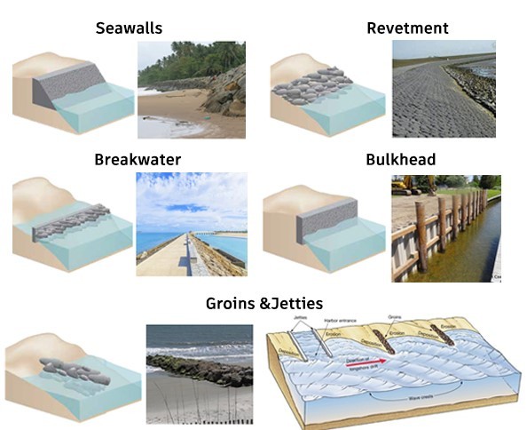
As seen in the image above, there are several different structures that can be used to prevent shoreline erosion. Seawalls are vertical or near vertical structures. They are placed parallel to the shoreline and used to prevent erosion and flooding. Usually they are made from concrete and are along a considerable stretch of coastline. Seawalls though are susceptible to passive erosion and the shoreline will migrate landward and the beach will become smaller. Next there are revetments which are built to protect the existing shoreline and protect the slope. They absorb the energy of incoming water. Some common materials include boulders or concrete shapes (tetrapods). One benefit of revetments is that they are low cost. Breakwaters are another common structure and are constructed to protect against tides, currents, and storm surges. You can usually see them at the entrance to harbors or ports. Most are usually within 100-300 feet of shore, in shallow water. Bulkheads are similar to seawalls, but think of them more like retaining walls. Lastly there are groins and jetties. They are usually installed along beaches perpendicular to the coastline to protect against longshore drift (we won't get into much detail here but basically its the process how sand moves along a beach). These are probably the form of coastal protection most people are familiar with since they can be see along many beaches.
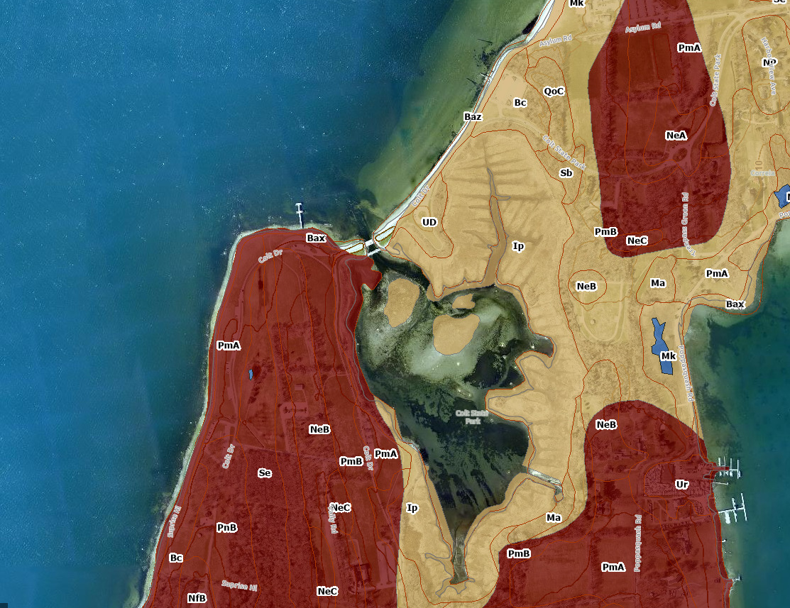
The screenshot of the map above (from the RIDEM Environmental Resource Map)shows the surface geology of Colt State Park. The letters correspond to the different types of soils that are found here. We will primarly be focusing on PmA, which is Pittstown Silt Loam. However more information on the other types of soils in the park can be found here. The letter at the end describes the slope of the land, A refers to 0-3% slope while B is a 3-8% slope. Pittstown Silt Loam is a moderately well drained soil and forms the crest of glacial upland hills and drumlins (elongated hill in shape of inverted spoon). Stones can be found in the surface of the soil. The surface is a dark gray/brown silt/loam and the subsoil (the layer found underneath is a dark yellow/brown color. It can also be found mixed in with well drained Newport soils and poorly drained Stissing soils. It is also important to mention that seasonally, the soil has a high water table. The type of soil is important since it can affect coastal erosion. Silt size particles are more susceptible to erosion compared to sand or clay.
Logging Requirements:
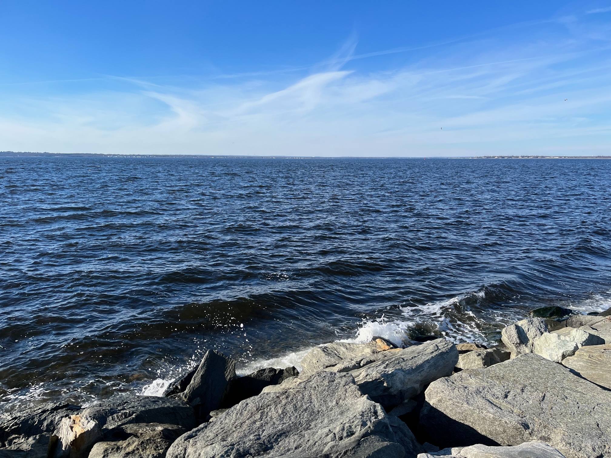
- Observe the shoreline in front of you. What structure (if any) is used to protect against shoreline erosion? Is it visible along the entire shoreline or just a small stretch? Estimate its height.
- Look at the ground behind the shoreline structure. Based on what you have learned, do you think this soil erodes slowly, moderately, or rapidly and why? Why do you think this area was chosen for this shoreline protection structure?
- Do you think this structure is an adequate solution to alleviate storm damage? Why or why not?
- What might be some unintended consequences as a result of the structure, in future years?
- Upload a photo taken at Colts State Park. You don't have to be in the photo, though it is strongly encouraged.