To
log this earthcache, send me an email with the answer
to the following questions:
1. When did
the "last glacial maximum" occur in the Pyrenees?
Why can we see very old rocks (Paleozoic) in the
highlands of Ordesa?
2. How long did the formation of
the Pyrenees mountain range last? What was the first
horse riding in the genesis of the Pyrenees?
3. Look at the ground you are
stepping on. Indicate its color, if it is sandy or
compact and if you can see or not layers in the rock
4. Add a photograph
of you in the premises, or another in which you can
see an object, or your nick on a piece of paper
If you believe you have successfully completed this
Earth Cache goals and has already sent to me all the
requirements as requested, Please, feel free to log
it as found. Later i will verify the requirements
sent and, if necessary, contact you in order to make
the necessary corrections to your log.
|
|
Location
The Ordesa y Monte Perdido National Park is part of the
physiographic unit of the Monte Perdido massif, the highest
calcareous mountain in Europe, at 3,355 metres. Located within the
Ordesa y Monte Perdido National Park, it was listed as a Biosphere
Reserve in 1977 and as a World Heritage Site by UNESCO in 1997.
Declared a National Park in August 1918, the second oldest in
Spanish territory, its spectacular nature It has attracted
millions of tourists to travel through it enjoying one of the most
breathtaking landscapes that exist. Some of its visitors are as
illustrious as Sir Charles Lyell, one of the fathers of modern
geology and who in 1830 toured the Monte Perdido Massif studying
its geology.
The main characteristic of its landscape and, therefore, what most
attracts attention, is the succession of ridges, needles, deep
valleys and canyons that show the vigor and energy of the forces
that intervened in its formation and the apparent youth of its its
relief. However, there is a proven balance between the abrupt
forms due to glacial action and the flattened ones, which are due
to periglacial erosive phenomena.
The massif cannot be broken down as an isolated fact, but as a
part of the whole of which it is a part. The great thrusts in a
north-south direction, from the French Central Massif and retained
in the Spanish Plateau, which acted as press stops, displaced the
Hercynian materials, which caused the current Pyrenean mountain
range to rise as a consequence of sliding, folding and thrusting.
of the deposited sedimentary series, as well as the fracturing and
covering of the remains of the Hercynian massif
Origin
Although
today the Pyrenees constitute a large mountain range of the
Iberian Peninsula and a geographical barrier that separates
Spain from France, its origin is -geologically speaking-
relatively "recent". The place occupied today by the mountains
constituted a sea until about 35 million years ago. Testimony of
this process are the fossil remains of organisms that lived on
the seabed and that today we find in the rocks that constitute
the highest peaks of the National Park, such as Monte Perdido,
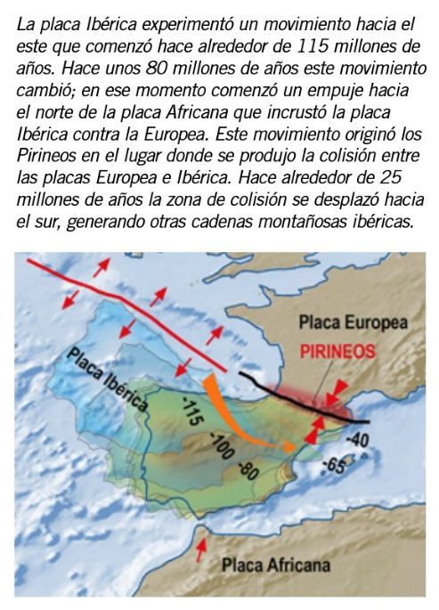
at more than 3,300 meters above sea level. . The formation
process of the mountain range took place over 250 million years.
During the first part of this period, sediments accumulated in a
marine basin that was later uplifted to form the Pyrenean
mountain range.
In other parts of the Park, below the rocks that form the walls
of these three valleys, there are older rocks, such as in the La
Larri valley, where under the Upper Cretaceous strata we find
red-colored sandstones deposited during the Permian and Triassic
periods. , and below it intensely folded stratified rocks
deposited during the Paleozoic era. Thus, we can take a tour of
the different episodes in the history of the Earth in this
sector of the Pyrenees, paying close attention to the rocks of
the National Park.
In the entire northern band of the geological map, already
outside the limits of the National Park, we find outcrops of
intensely folded rocks. These are rocks much older than the
strata of the Ordesa and Añisclo valleys. They were deposited
between 470 and 350 million years ago in the Paleozoic era and
were deformed when a large mountain range was formed: the
Variscan Chain during the Carboniferous period. This chain
suffered great erosion and was completely destroyed before the
formation of the Pyrenees. The fact that today we find these
rocks on the surface forming the core of the Pyrenees is due to
their uplift during the Alpine orogeny.
200 million years ago the great Variscan mountain range was
rapidly eroding. At that time in the area of ??the Pyrenees
there were extensive alluvial and fluvial areas where red
colored sediments were deposited.
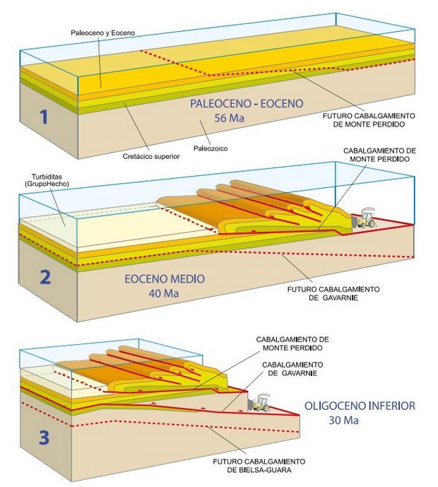
1. Initial state at the end of the Paleocene.
2. In the middle Eocene, the small tectonic units (flakes) that
make up the U. of Monte Perdido had already been emplaced, and now
the entire U. of Monte Perdido is moving on its lower thrust,
which cuts the strata upwards.
3. During the lower Oligocene, the Gavarnie unit moves: the Monte
Perdido Unit is already immobile and below it, the tectonic
compression causes the rupture and creation of a new thrust, which
already cuts the units of the Paleozoic base. The latter is the
Gavarnie Thrust, which in its movement carries on its back the U.
de Mte. Lost that folds as a result of bulging
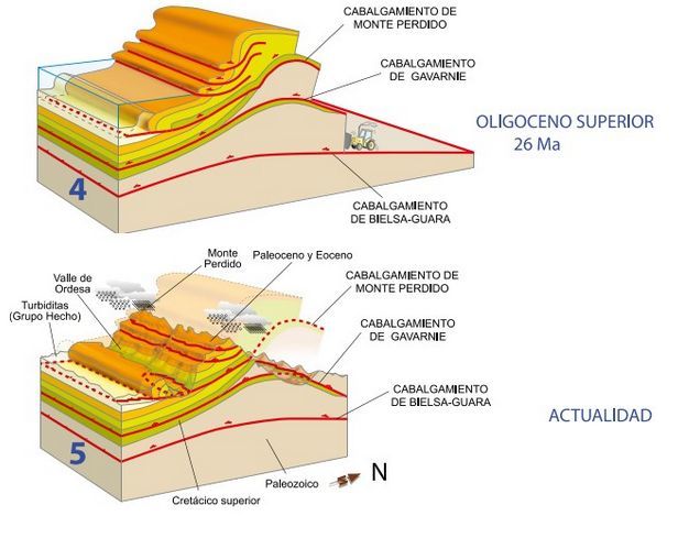
4. In this episode, a new deeper thrust is formed below all
the previous ones, the Bielsa-Guara Thrust, which carries the
previous ones on itself. As with the C. de Gavarnie, its
displacement causes the overturning of all the units previously
placed to the south.
5. Current situation: the intense erosion of the Pyrenees has
exposed the tectonic structure: in the deep Gavarnie valley, the
thrust that receives its name has come to light and surrounds the
entire valley, constituting a so-called "tectonic window".
The Monte Perdido massif is a large rocky building constituted by
the stacking of many units of rocks repeated one on top of the
other until constituting this great mass. The different pieces
that compose it -tectonic units-, are
emplaced over 80 million years. However, contrary to what it may
seem, it is the units that are highest in the building that are
placed first. In this way they were progressively pushed up and
deformed by those that were later placed under them by raising
them to their current position
Geological
sections through the National Park showing the structural
units. The peaks of Monte Perdido and Mondarruego correspond
to the mantle of Monte Perdido, made up of several minor
thrusts.
Glaciarism
Much of the spectacular landscapes of the National Park are due to
the action of glaciers. Ice covered a good part of the National
Park a few thousand years ago, something that may seem like a long
time but is very recent in geological terms. In fact, there are
still active glaciers in the National Park that, although in clear
recession, show the dynamics of these ice colossi. To understand
the extent and significance of glacialism in the National Park, it
is necessary to understand how the Quaternary glaciations
developed in the Pyrenees.
The maximum “recent” expansion of the ice in the Pyrenees took
place between 65,000 and 45,000 years ago, a moment that is known
as the “last glacial maximum”. Long glaciers tens of kilometers
long descended through the valleys, in the same way that they do
today through the Himalayas or the Alps, and powerful ice caps
covered the great Pyrenean mountains. The Pyrenean glaciers
reached more than 50 kilometers in length on the northern (French)
slope and more than 40 on the southern (Spanish), with thicknesses
of up to 800 meters of ice in some places.
|