Este CE único conta-nos a história de poços de água doce que emergem na entrada do mar de água salgada. Ou seja: a força da água versus as camadas calcárias porosas da faixa costeira. Esta não é uma CE sobre a água em si, mas sobre a vulnerabilidade destas camadas do solo. A água não é aqui estudada pelas suas propriedades fluidas, mas como evidência indireta da geologia, da porosidade do solo, da estabilidade da paisagem e das consequências da influência da água sobre estes elementos.
Olhos de Água é uma vila à beira-mar na costa algarvia de Portugal, a cerca de cinco quilómetros a leste da cidade de Albufeira. Olhos de Água deve o seu nome às nascentes de água doce que se localizam sob a praia em determinados locais da costa. Na maré baixa, essas nascentes desprendem-se e formam manchas arredondadas na praia onde a água brota. Essas manchas redondas parecem “olhos de água”, e é assim que também estão incluídas no brasão da aldeia. A descoberta destas nascentes foi feita por um lavrador que pastoreava as suas cabras nas falésias junto ao mar. O lavrador ficou surpreso ao ver que uma das suas cabras se dirigia para o mar assim que chegou ao penhasco. Tentando proteger o animal, seguiu-a e surpreendeu-se ao perceber que havia água doce a jorrar da rocha para o mar. Com as mãos em concha, provou o líquido e confirmou que era água fresca. O local foi então chamado de “Primavera da Cabra”. Mais tarde, descobriu-se que havia outras nascentes numa área de 300 metros. A povoação passou então a chamar-se “Olhos de Água”, e o seu nome foi registado no início do século XX. A água das nascentes é boa, fria e fácil de beber. No passado, toda a aldeia era abastecida com água potável dessas fontes.
A água doce encontrada nos “olheiros” é proveniente do sistema aquífero Albufeira–Ribeira de Quarteira, alimentado pelos sumidouros do Escarpão, formados por rocha calcária que permite a infiltração das águas da chuva. Devido à erosão ao longo da costa portuguesa, é possível encontrar muitos fósseis e diferentes tipos de hematite. Esta é frequentemente a causa da coloração vermelha de muitas rochas sedimentares. A cor vermelha e o facto de a hematite não ser tóxica tornam este mineral muito adequado como pigmento. Já na Idade da Pedra era usado para petróglifos e pinturas corporais. Como pigmento, a hematite é adequada para pintura de cerâmica e para o tingimento de fios destinados a tapetes. O calcário sofre erosão sob a influência da infiltração das águas pluviais que, devido ao elevado teor de dióxido de carbono, acidificam e dissolvem o calcário. Este processo contínuo alarga gradualmente as fissuras no subsolo, formando um rio subterrâneo que serpenteia pelas camadas calcárias. As cavidades tornam-se maiores e podem estender-se por quilómetros no subsolo. Quando o rio subterrâneo desagua no mar, a água pode voltar à superfície de várias maneiras. Em alguns casos, simplesmente flui para o mar e não retorna à superfície. Noutros casos (como em Olhos de Água), pode ser pressurizada e subir através de fendas no fundo do mar, criando uma nascente submarina. Quando a água do mar recua devido à maré baixa, surgem nascentes de água doce na praia, pois deixam de estar limitadas pela pressão da água do mar.
.
Rochas e crinídeos na praia
Na beira da água encontram-se muitas rochas sedimentares espalhadas por toda a praia. Estas resultam da erosão subterrânea e da ação da água, que as deposita novamente na praia. Se observar com atenção, verá muitos crinóides. Estes fósseis de lírios-do-mar são conhecidos há muito tempo, pois encontram-se em grandes quantidades em formações rochosas. Os lírios-do-mar existem há quase 500 milhões de anos e são considerados fósseis vivos. Os primeiros são conhecidos desde o Ordoviciano e eram habitantes de mares rasos. Floresceram no período Siluriano, entre 350 e 400 milhões de anos atrás, e eram particularmente abundantes no período Carbonífero. Algumas formações calcárias, como as formações rochosas ao longo da costa de Portugal, consistem principalmente em restos de lírios-do-mar formados por deposição e compactação sob pressão das camadas sobrejacentes.
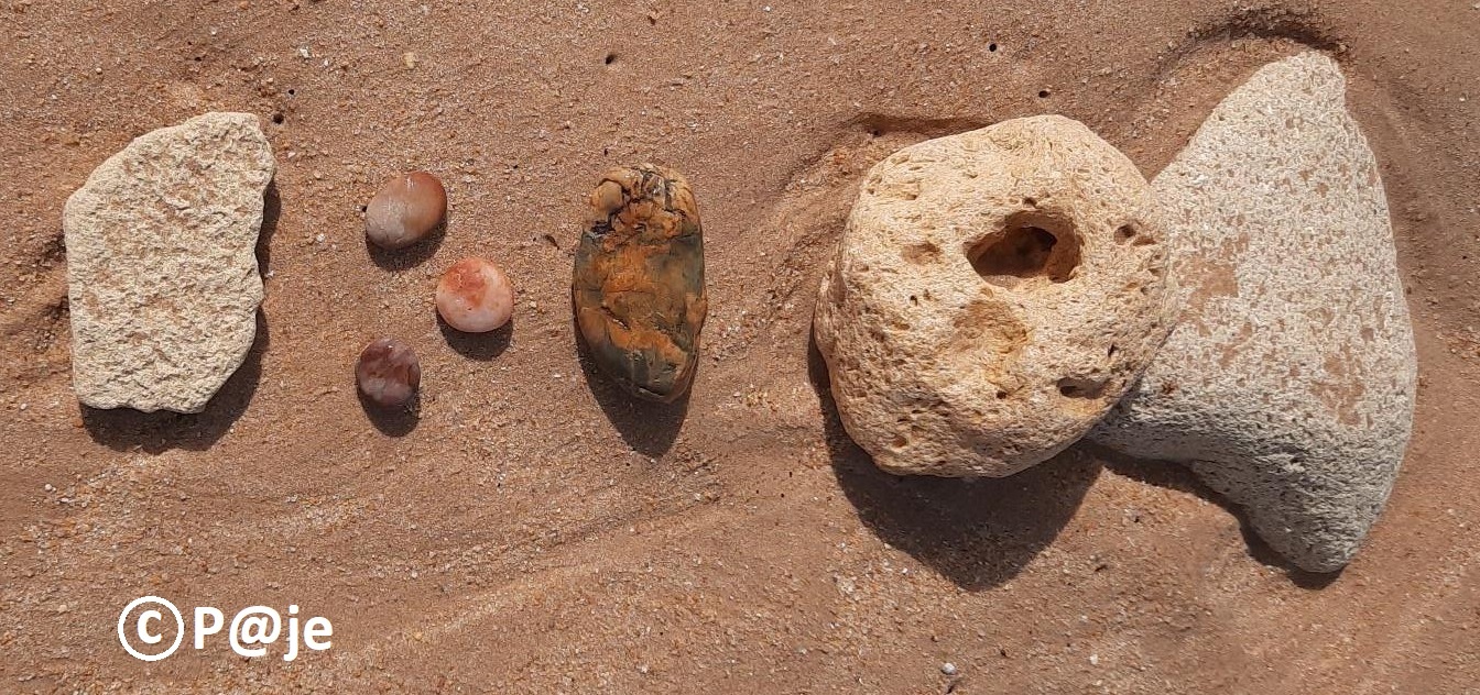
Granulometria:
As rochas sedimentares estão divididas em várias categorias e são muito variadas, cobrindo cerca de 75% da área terrestre. São constituídas por materiais desintegrados, intemperizados e transportados, por precipitação química ou por materiais de origem mista. No caso dos calcários e calcários dolomíticos, a distinção é feita com base em três critérios: a abundância de fósseis macroscopicamente reconhecíveis, a reconhecibilidade da textura ou a natureza da rocha (por exemplo, precipitação química). Para calcários fossilíferos, o fóssil dominante é sempre mencionado (por exemplo, rico em crinóides, fragmentos de conchas, etc.).
Porosidade do solo - Estabilidade da paisagem:
A água meteórica infiltrada, enriquecida em CO₂, forma ácido carbónico fraco e provoca a dissolução de CaCO₃ no calcário. Isto conduz a um aumento da porosidade secundária e da condutividade hidráulica.
À medida que a água subterrânea doce exfiltra na zona costeira, a matriz rochosa é localmente enfraquecida devido à perda de material e à diminuição da coesão e da tensão efetiva. A combinação da dissolução química e da ação mecânica das ondas provoca o solapamento da base da arriba, reduz a resistência ao cisalhamento e diminui a estabilidade da paisagem, aumentando a probabilidade de recuo da arriba, desmoronamentos e retração costeira acelerada..
Questões: Como em todas as “earthcaches”, não existe um “container” ou “logbook” físico. Responda às seguintes questões para registar e validar esta “earthcache”:
1) Observação : Verifique nas rochas se existem vestígios de erosão (fissuras). Em que direção ocorreu o fragmentamento da rocha? O que isto sugere sobre a orientação da rocha quando foi formada há milhares de anos?
2) Granulometria: Na praia vê muitas rochas sedimentares. Qual é o tamanho aproximado das pedras?
Uma foto sua ou do GPS no local 3, mostrando as fontes, é bem-vinda, mas opcional.
...e desfrute da visita a este magnífico local.
ponto final dos poços fluviais subterrâneos
endpoint of the underground river wells
This unique EC tells us the story of freshwater wells emerging at the entrance of the saltwater sea. In other words: the strength of the water versus the porous limestone layers of the coastal strip. This is not an EC about the water itself, but about the vulnerability of these soil layers of the earth.
Water is not studied here for its fluid properties, but as indirect evidence of geology, soil porosity, landscape stability, and the consequences of water's influence on these.
.
History:
Olhos de Água ("eyes of water") is a seaside village on Portugal's Algarve coast, about five kilometers east of the city of Albufeira. Olhos de Água owes its name from the freshwater springs that are located under the beach in certain places on the coast. At low tide these springs are released and form round spots in the beach in which the water wells up. These round spots look like 'eyes of water' and that is how they are also included in the coat of arms of the village. The discovery of these springs was made by a farmer who used to shepherd his goats on the cliffs by the sea. The farmer was surprised that one of his goats was heading for the sea as soon as he reached the cliff. Trying to protect his animal, he followed it and was surprised – he realized that there was fresh water spouting through the rock into the sea. With his hands he made a ladle to taste the liquid and confirmed that it was fresh water. The place was soon called “Goat’s Spring”. However, later it was found that there were other springs in an area of 300 meters. The village was then called the “Olhos de Agua” (Water Eyes) and its name was registered in the early twentieth century. The water from the springs is nice and cold and easy to drink. In the past, the entire village was supplied with drinking water from these sources.
Origin
The fresh water found in the “eyes” comes from the aquifer system Albufeira-Ribeira de Quarteira, fed by the Escarpão sinks formed by limestone that allow the filtration of rainwater. Due to the erosion along the Portuguese coast you can find a lot of fossils and different types of hematite. This is often the cause of the red coloring of many sedimentary rocks. The red color and the fact that hematite is non-toxic make the mineral very suitable as a pigment. Already in the Stone Age it was used for petroglyphs and for body paintings. As a pigment, hematite is suitable for painting ceramics and dyeing threads for carpets.
The limestone erodes under the influence of infiltration of rainwater which, due to the high carbon dioxide, acidifies and dissolves the limestone. This continuous process gradually widens the cracks in the subsurface, forming an underground river that winds its way through the limestone layers. The cavities become larger and can travel for kilometers underground. When the underground river flows into the sea, the water of the river can come back to the surface in various ways. In some cases, the water from the river simply flows into the sea and there is no return to the surface. In other cases (as in Olhos de Água), the river's water can be pressurized and rise through cracks in the seabed, creating a spring on the seabed. When the sea water recedes due to low tide, you get freshwater springs that form on the beach as they are no longer limited by the limestone layers.
.
Rocks and crinoids at the beach
At the water's edge you will find a lot of sedimentary rocks spread all over the beach. These are the result of underground erosion and the rising water that deposits them back on the beach. If you observe carefully you will see many crinoids. These sea lily fossils have been known for a long time because they are found in large quantities in rock formations. Sea lilies have been around for almost 500 million years and are considered living fossils. The first sea lilies are known from the Ordovician, and were inhabitants of shallow seas. Sea lilies flourished in the Silurian period, about 350 to 400 million years ago. They were most numerous in the Carboniferous period. Some limestone formations, such as the rock formations along the coast of Portugal, consist mainly of the remains of sea lilies formed by systemic sclerosis, deposition and pressure from overlying soil layers.
Granulometry:
Sedimentary rocks are divided into a number of categories and are very varied as they cover 75% of the land area. They consist of disintegrated, weathered and transported materials, of chemical precipitations or of materials of mixed origin. With limestones and dolomitic limestones, a distinction is made on the basis of three criteria: the abundance of macroscopically recognizable fossils, the recognisability of the texture or on the basis of the nature of the stone (e.g. chemical precipitation). For fossil-bearing limestones, the dominant fossil is always mentioned (e.g. rich in crinoids, shell fragments, etc.).
Soil porosity - Landscape stability:
Infiltrating meteoric water enriched with CO₂ forms weak carbonic acid and causes the dissolution of CaCO₃ in limestone. This results in an increase in secondary porosity and hydraulic conductivity. As fresh groundwater exfiltrates at the coast, the rock matrix is locally weakened due to material loss and a reduction in cohesion and effective stress. The combination of chemical dissolution and mechanical wave action causes undercutting at the cliff base, reduces shear strength, and decreases landscape stability, thereby increasing the likelihood of cliff retreat, collapses, and accelerated coastal recession.
Questions: as for all the earthcaches there is no container to find or physical logbook to sign. Send me by email (in profile) the answers to the following questions to log and validate the earthcache:
1) Observation : Check the rocks if you can see some traces of erosion (cracks). In which direction has the spalling of the rock occurred ? What does this suggest about the orientation of the rock when it was found thousands of years ago ?
2) Granulometry: on the beach you see many sedimentary rocks. What is the size (approximately) of the stones?
A picture of you or gps at location 3 overviewing the sources is welcome but optional.
...and enjoy the visit of this magnificent place.
.
Fontes / Sources :
https://www.visitalgarve.pt/pt/2252/praia-dos-olhos-d%C2%B4agua.aspx
https://pt.wikipedia.org/wiki/Escala_de_tempo_geol%C3%B3gico
https://pt.wikipedia.org/wiki/Hematita
https://pt.wikipedia.org/wiki/Crinoidea