

Welcome to Egypt on the Red Sea in Marsa Alam
Welcome to Madinat Coraya Bay on the beach.
We already spent several vacations in this beautiful country and city.
We were thrilled, among many great things, the nice people and the beach.
This has brought me to the idea here an EC to this topic.
So I hope to be able to offer here an instructive EC that makes you fun.
Here now some general information about this part of the coast.
The city of Marsa Alam is located on the Red Sea, in the governorate of al-Bahr al-ahmare, 271 kilometers south of Hurghada on the western bank of the Nile. Edfu is about 220 kilometers away and ash-Shalatin is about 250 kilometers south. To the north, the city of al-Qusair is about 131 kilometers away.
Marsa Alam has grown in the last two decades from a coastal village with a handful of low stone huts to a small town. It owes its importance to the important junction of the continuous coastal road with the connecting road to Edfu in the Nile Valley and to tourism, which has so far been concentrated mainly in the hotels on the coast. First accommodations and restaurants indicate the hesitant beginning of a tourist development.
Since November 2001, Marsa Alam has been directly accessible via the new Marsa Alam airport, which is about 6 kilometers away.
( Source: wikipedia )
Here now some general information about this area.
You are here at the "Madinat Coraya" - "Coraya Bay" on the beach.
Originally, the bay was used as a ship berth.
What there is not only in the Sahara, but also here on the beach is of course sand.
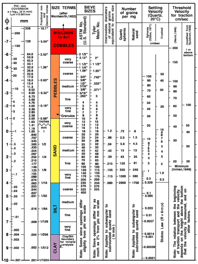
Grain size
Grain size is the equivalent diameter of particles (grains) of clastic sediments (products of weathering and mechanical rearrangement) and soil particles. The particle size classification according to DIN 4022 distinguishes between clay, silt, sand, gravel and stones. The grain size classification according to Udden & Wenthworth, modified after Doeglas, includes clay, silt, sand, granules, pebbles, cobbles and boulders. Both of the above scales use millimeters as the unit. An arithmetic scale is the grain size division according to Phi as a logarithmic transformation of the Udden-Wenthworth scale.
where d = grain size in millimeters. Grain sizes can be determined by different methods, such as sieve analysis, sedimentation analysis or optical methods. It should always be borne in mind that when determining from thin sections, only a two-dimensional section is recorded, which can cause considerable problems with more complicated grain shapes. The standard method for determining grain sizes in thin sections is the chordal section method. The following classification according to mean grain size has become widely accepted internationally for terrain analysis: fine-grained: 1 mm, medium-grained: 1-5 mm, coarse-grained >5 mm. In Germany, the grain size classification for crystalline rocks according to Teuscher is also commonly used.
But now to the sand, and its classification
YOUR TASK FOR THE CACHE:
1.) How many types of sediments do you find and what size have these ?
Please sort the sediments according to the Wentworth scale.
2.) Examine each of the sediments very carefully and check which mineral it is.
A.) Monomineral (consisting of only one type of material)
B.) Polyminerals (consisting of several types of material)
3.) Let dry sand trickle through your hands, then pat hands. What feeling remains on the skin?
A) The feeling as if the hands were roughened by sandpaper.
B) The feeling of powdered sugar between the fingers.
C) The feeling of moisture, although the hands were dry before.
IMPORTANT: Describe in your own words why it is like that.
4.) On the way from Stage 1 to Stage 3 you walk on the promenade.
You will pass a round sign with the number "1500 m".
Question: What number is written on the back of this sign?
5.) When you arrive at Stage 3, take a look at the ground and see what you notice most.
What exactly are you standing on here?
6.) At Stage 3 look towards the sea and look at the large right rock protrusion that goes into the water.
a.) Please describe the color gradient of the rock layer, from top to bottom.
b.) What is the bottom layer made of (you can also find it separately, also in larger formations at your location) and explain its origin?
7.) Create a log photo for the log with you in front of the Rock ( Stage 2 ) on the promenade.
and, if you want Optionally also a heart in the sand incl. the date.
Sample:

Of course, I am happy about every other posted photo to spark the travel fever.
I wish you a lot of fun with this EC and a nice time in the city & the beach on the red sea.
Send me your five answers and include the log photos
Then you may log immediately, if the answers are not correct I will contact you.
If I do not receive any answers or the log photo is missing, I will have to delete your logs.
.........................

Willkommen in Ägypten am roten Meer in Marsa Alam
Willkommen in Madinat Coraya Bay am Strand.
Wir verbrachten dieses Jahr unseren Urlaub in diesem schönen Land.
Uns begeisterte, neben vielen tollen Dingen, die nette Menschen & der Strand.
Das hat mich zu der Idee gebracht hier einen EC zu diesem Thema auszulegen.
So hoffe ich hier einen lehrreichen EC anzubieten zu können der Euch Spaß macht.
Hier nun einige allgemeine Informationen zu diesem Küstenbereich.
Die Stadt Marsa Alam liegt am roten Meer, im Gouvernement al-Bahr al-ahmare, 271 Kilometer südlich von Hurghada am westlichen Nilufer. Edfu ist etwa 220 Kilometer entfernt und asch-Schalatin liegt etwa 250 Kilometer südlich. Im Norden befindet sich in etwa 131 Kilometern die Stadt al-Qusair.
Marsa Alam ist in den letzten zwei Jahrzehnten von einem Küstendörfchen mit einer Handvoll niedriger Steinhütten zu einer Kleinstadt gewachsen. Ihre Bedeutung verdankt sie dem verkehrstechnisch wichtigen Knotenpunkt der durchgehenden Küstenstraße mit der Verbindungsstraße nach Edfu im Niltal und dem Fremdenverkehr, der sich bisher vor allem in den Hotels an der Küste konzentriert. Erste Unterkünfte und Restaurants weisen auf den zögerlichen Beginn einer Touristenentwicklung hin.
Seit November 2001 ist Marsa Alam direkt über den neuen Flughafen Marsa Alam, der etwa 6 Kilometer von hier entfernt liegt, erreichbar.
QUELLE: wikipedia
Ihr befindet Euch hier am "Madinat Coraya" - "Coraya Bay" am Strand.
Ursprünglich wurde die Bucht als Schiffsliegeplatz genutzt.
Was es nicht nur in der Sahara gibt, sondern auch hier am Strand ist natürlich Sand.
Darum geht es hier auch in der Hauptsache bei diesem EC.
Korngröße
Korngröße, bezeichnetden Äquivalentdurchmesser von Teilchen (Körnern) klastischer Sedimente (Produkte von Verwitterung und mechanischer Umlagerung) und Bodenpartikeln.Es werden verschiedene Korngrößeneinteilungen verwendet. Die Korngrößeneinteilung nach DIN 4022 unterscheidet Ton, Schluff (Silt), Sand, Kies und Steine. Die Korngrößeneinteilungnach Udden & Wenthworth, modifiziert nach Doeglas, beinhaltet clay (Ton), silt (Silt), sand (Sand), granules, pebbles, cobbles (Kies) und boulders (Steine). Die beiden genannten Skalen benutzen als Einheit Millimeter. Eine arithmetische Skala ist die Korngrößeneinteilung nach Phi als logarithmische Transformation der Udden-Wenthworth-Skala.
wobei d = Korngröße in Millimetern. Korngrößen können mit unterschiedlichen Methoden bestimmt werden, wie z.B. durch Siebanalyse, Sedimentationsanalysen oder optische Verfahren. Zu bedenken ist stets, daß bei der Bestimmung aus Dünnschliffen nur ein zweidimensionaler Anschnitt erfaßt wird, was bei komplizierteren Kornformen erhebliche Probleme erzeugen kann. Standardverfahren zur Bestimmung von Korngrößen im Dünnschliff ist das Sehnenschnittverfahren. Folgende Einteilung nach der mittleren Korngröße hat sich für die Geländeansprache international weitgehend durchgesetzt: feinkörnig: 1 mm, mittelkörnig: 1-5 mm, grobkörnig >5 mm. In Deutschland auch gebräuchlich ist die Korngrößeneinteilung für Kristallingesteine nach Teuscher.
Doch nun zum Sand und seiner Klassifizierung
EURE AUFGABE ZUM CACHE:
1.) Wie viele Arten von Sedimenten findest Du, und in welche Größe haben diese ?
Sortiere bitte die Sedimente anhand der Wentworth-Skala.
2.) Untersuche jedes der Sedimente sehr genau und prüfe um welches Mineral es sich handelt.
A) Monominerale (bestehend aus nur einer Materialart)
B) Polyminerale (bestehend aus mehreren Materialarten)
3.) Lass trocken Sand durch die Hande rieseln, nun Hände abklopfen. Welches Hautgefühl bleibt ?
A) Das Gefühl als wären die Hande wie von Schleifpapier aufgeraut.
B) Das Gefühl von Puderzucker zwischen den Fingern
C) Das Gefühl von Feuchtigkeit obwohl die Hände vorher trocken waren.
WICHTIG: Beschreibe in eigenen Worten warum dieses so ist.
4.) Auf dem Weg von Stage 1 zu Stage 3 gehst Du auf der Promenade.
Dabei kommst Du an einem rundem Schild mit der Zahl "1500 m" vorbei.
Frage: Welche Zahl steht auf der Rückseite von diesem Schild ?
5.) An Stage 3 angekommen schau Dir den Boden an, was fällt dir hier besonders auf.
Auf was genau stehst Du hier ?
6.) An Stage 3 schau Richtung Meer und betrachte Dir den großen rechten Felsvorprung der ins Wasser geht.
a.) Beschreibe mir bitte den Farbverlauf der Gesteinsschicht, von oben nach unten
b.) Woraus besteht die unterste Schicht ( findest Du auch einzeln, auch in größere Formationen an Deinem Standort ) und erkläre mir den Ursprung?
7.) Erstelle für den Log ein Logfoto mit Dir vor dem Felsbrocken ( Stage 2 ) an der Promenade.
und wenn Du möchtest Optional auch ein Herz im Sand inkl. Datum.
Beispiel:
Natürlich freuen ich mich über jedes weitere eingestellte Foto um das Reisefieber zu entfachen.
Ich wünsche euch viel Spaß bei diesem EC und einen schöne Zeit an diesem Strand am roten Meer.
Schickt mir Eure fünf Antworten und stellt das/die Logfoto/s mit ein.
Dann dürft ihr sofort loggen, sollten die Antworten nicht stimmen werde ich mich bei Euch melden.
Sollte ich keine Antworten erhalten oder das Logfoto fehlen, werde ich leider Eure logs löschen müssen.
.........................
Wer möchte kann das Banner in sein Profil einbauen.
Whoever wants to can add the banners to their own profile.

Füge dazu einfach folgenden Code in Dein Profil ein: / Just add the following code to your profile:
<a href="http://coord.info/GCA94R0" target="_blank"><img src="https://img.geocaching.com/cache/large/36443876-58d8-4228-b116-a587c88fc22a.jpg?rnd=0.4016322" border="0" /></a>
Für die ersten drei Finder gibt es eine kleine Tabelle! / For the first three finders there is a small table!
1.) MiaFu
2.) danielst
3.) ka.pa
