 Nuottaniemen drumliini - Mikä on drumliini?
Drumliini on jääkauden aikana syntynyt pitkänomainen maastonkohouma. Ne syntyivät, kun mannerjäätikkö eteni ja kuljetti mukanaan runsaasti irtoainesta eli moreenia, joka kasautui tiiviisti pakkautuneisiin kohtiin, kuten kalliokohoumien viereen. Näin muodostui jäätikön suuntaisia selänteitä eli drumliineja.
Drumliinin tyypillinen muoto on sikarimainen ja se koostuu jyrkästä päästä ja loivasta päästä. Jyrkkää päätä kutsutaan proksimaaliosaksi ja loivaa taas distaaliosaksi. Monesti drumliinin proksimaaliosassa on kallioydin, jonka koko vaihtelee drumliinin koon mukaan. Kallioydin sijaitsee aina jäätikön tulosuunnan puoleisessa päässä. Kallioytimestä poispäin jäätikön menosuuntaan jatkuu asteittain madaltuva "moreenihäntä". Jäätikkö eteni tällöin kalliokohouman yli ja kuljetusaineet muodostivat moreenihännän.

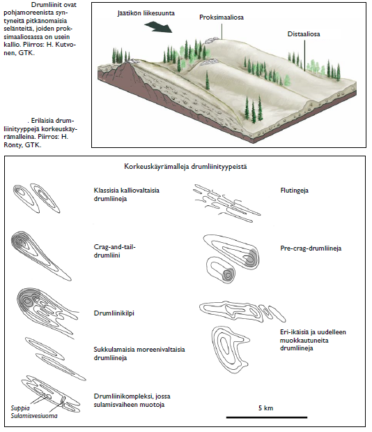
Drumliinit ovat yleinen pinnanmuoto Suomessa ja ne ovatkin Suomen merkittävin moreenimuodostumien tyyppi niin lukumäärässä kuin koossakin. Suomesta tunnetaan myös drumliinikilpiä, jotka ovat leveitä drumliinien ryhmiä. Niissä suurimmat drumliinit ovat 90–120 metriä korkeita, 2–7 kilometriä pitkiä ja 0,5–2 kilometriä leveitä. Suomessa on drumliinikilpiä muun muassa Pieksämäen lähistöllä sekä muualla Savossa. Lisäksi tunnetaan monia drumliinien vaihettumistyyppejä, joita on esitetty ylläolevassa kuvassa.
Nuottaniemen drumliini on ns kalliodrumliini, jossa moreeni peittoaa maaperää vain ohuna kerroksena. Nuottaniemen drumliini on suurimmasta osasta drumliineista poikkeava rakenteeltaan. Drumliini sijaitsee keskeisellä paikalla ja kohoaa maastosta Sepet-torpan puiston vieressä. Lähin parkkipaikka on reittipisteissä.
Tehtävät
1) Kulje drumliini päästä päähän annetuista koordinaateista koordinaatteihin N 60 08.947 E 24 44.403. Onko Nuottaniemen drumliinissa havaittavissa drumliinien tunnusmerkkejä? Mikä on ollut jäätikön liikesuunta ja mistä voit todistaa tämän?
2) Minkä tyypin drumliini on kyseessä, kun katsot kuvauksen kuvaa ja tekstiä?
3) Vapaaehtoinen: Ota kuva itsestäsi tai henkilökohtaisesta esineestäsi jossain drumliinin alueella.
Voit logata kätkön lähetettyäsi vastaukset profiilisivun kautta.
 The drumlin of Nuottaniemi - What is a drumlin
A drumlin is a long landform formed during the Ice Age. They were formed when the continental glacier advanced and carried with it a lot of loose material, or moraine, which piled up in tightly packed places, such as next to rock outcrops. In this way ridges parallel to the glacier, or drumlins, were formed.
The typical shape of a drumlin is cigar-shaped and consists of a sharp end and a gentle end. The steep end is called the proximal part (stoss end) and the gentle end is called the distal part (lee slope). Often in the proximal part of the drumlin, i.e. at the steep end, there is a rock core, the size of which varies according to the size of the drumlin. The rock core is always located on the side of the glacier inflow. Away from the rock core in the direction of the glacier, a gradually lowering "moraine tail" continues, which can be very long.
f
Drumlins are a common landform in Finland and they are the most significant type of moraine formations in Finland, both in number and size. Drumlin shields are also known from Finland, which are wide groups of drumlins. In them, the largest drumlins are 90–120 meters high, 2–7 kilometers long and 0.5–2 kilometers wide. There are drumlin shields, for example, near Pieksämäki In addition, many types of phasing of drumlins are known shown in the picture.
Nuottaniemi's drumlin is a rock drumlin, where the moraine covers the soil only as a thin layer. It can also be verified in GTK's bedrock map. The drumlin is located in a central location and rises from the terrain next to Sepet-torppa park. The nearest parking lot is shown in the waypoints.
Tasks
1) Walk the drumlin end to end from the given coordinates to the coordinates N 60 08.947 E 24 44.403. Are there telltale signs of drumlins in Nuottaniemi's drumlin? What has been the direction of movement of the glacier and how can you prove this?
2) What type of drumlin is it when you look at the picture in the description and the text.
3) Voluntary: Take a picture of yourself or your personal item somewhere on the drumlin.
You can log the cache after sending the answers via profile page.