Skip to content

A természet küzdelme Multi-Cache

This cache has been archived.

MTVSZ: Sajnos a láda karbantartása fenntarthatatlanná vált.

More
Hidden : 6/11/2023
Difficulty:
2 out of 5
Terrain:
3 out of 5

Size: Size:   small (small)

Join now to view geocache location details. It's free!

Watch

How Geocaching Works

Please note Use of geocaching.com services is subject to the terms and conditions in our disclaimer.

Geocache Description:


Ez a geoláda a ClimateQuest sorozat része, amely 8 európai országban 43 rejtekhelyen keresztül vezet el olyan érdekes helyekre, amelyek valamilyen módon kapcsolódnak a természetvédelemhez vagy az éghajlatváltozáshoz. Magyarországon 6 geoládát helyeztünk el, de találhatsz még Bulgáriában, Romániában, Szlovákiában, Csehországban, Németországban, Lettországban és Litvániában is.

MEGKÖZELÍTÉS

A kiindulópont, amely 11,7 km-re van Pécs város központjától megközelíthető helyi busszal, autóval és kerékpárral is Pécs felől a 6-os úton keleti irányba elhagyva a város központját
Busszal a 14-es számú helyi járatra felszállhatunk Pécs belvárosában több - könnyen elérhető - ponton is (Pécs Zsolnay-szobor, Pécs-Árkád), kb. 30 percnyi menetidővel számolva érhetjük el a „Vashíd” elnevezésű megállót, amely a kiindulópont lesz.
Buszmenetrend itt megtalálható: https://mobilitas.biokom.hu/vonal/14
Autóval és kerékpárral Pécsről a 6-os úton keleti irányba induljunk el a városból kifelé. Pécs-Vasas elágazásnál kell elhagyni a főutat balra kanyarodva rátérve a Szövetkezet utcára. Haladjunk tovább, elérve a Pécs-Vasas táblát hamarosan jobb oldalon a vasasi temetőt elhagyva útelágazáshoz érünk, ahol balra kell fordulnunk. Rövidesen megpillanthatjuk a Vashíd nevű buszmegállót, amely valóban egy híd a patak felett. Ez a kiindulópontunk. Innen már gyalog menjünk tovább. Az autónkat itt bárhol le tudjuk parkolni az utcákban.

LEÍRÁS

Pécs-Vasas településrész története
Az első – ma már városrésszé vált – település, ahol az újkori mecseki bányászat elindult. Ennek megfelelően talán a vasasiak, az ottani összetartó közösségek ápolják leginkább a bányászhagyományokat. Akárcsak sok másik korábban önálló, mára Pécshez csatolt kis település, Vasas is lakott volt már az Árpád-korban és a török hódoltság alatt sem néptelenedett el, egészen a bányászat komolyabb beindulásáig színtiszta magyar falu volt. Az elmúlt pár évtizedben a kutatók találtak arra utaló jeleket, hogy a középkorban vasgyártás is folyt ezen a területen, a kitermelt agyagvasércből és vörösvasércből – minden valószínűség szerint innen a településrész neve. Vannak olyan elméletek is, hogy az itt élők vassal adóztak a pécsváradi apátságnak, ezért lett a település neve Vasas. Persze a két elmélet nem összeférhetetlen.

A szénbányászat centruma
Talán kijelenthető, hogy a nagy múltú mecseki szénbányászat egyik első központja Vasason volt, 1869-ben nyílt meg, akkor a legmodernebb Thommen-aknával (mai nevén Petőfi-akna). Ezt megelőzően, a kutatások és a fennmaradt dokumentumok alapján az biztos, hogy már a 18. század közepén zajlott a szénbányászat Vasason. 1782-ben a pécsváradi apátság is csatlakozott a kitermeléshez, és megnyílott a mecseki szénmedence első szénbányája (az országban harmadikként). A bányászat és vele együtt a település fellendülését jól mutatja, hogy 1840-ben már húsz polgár rendelkezett bányatelekkel. A folyamatos fejlődés magával hozta az idegen ajkú munkások érkezését – 1870 körül mintegy félezer külföldi – többségében német – telepedett le. Ekkor már egyeduralkodóként irányította a mecseki szénbányászatot a híres Dunagőzhajózási Társaság, sorra nyitotta meg az újabb aknákat.
Ha az idegen látogató áthalad Vasason, rögtön feltűnik neki Szent Borbála neve: közösségi ház, park, templomi festmények, oltár és út is viseli a nevét. Ezen nem is szabad meglepődni, hiszen Borbála a bányászok védőszentje. A negyedik században élt szent története szerint édesapja szigorúan eltiltotta lányát minden keresztény tantól. Ám ő mégis megkeresztelkedett. Mikor pedig édesapja erre rádöbbent, meg akarta ölni, Borbála egy barlangba menekült előle. Mégis elkapták, megkínozták, vértanúhalált halt. A bányászok minden évben koszorúzással tisztelegnek előtte. A bányászat csúcskorában, 1962-ben megkezdték a külszíni fejtést is, ez egészen 2004-ig zajlott – néhány éve pedig egy nagyon kicsi területen a külfejtésben újraindították a termelést.
1946-ban a szomszédos Somoggyal vonták össze, 1955-ben Pécshez csatolták. A szocializmus évtizedei alatt Vasas II. néven futott, Somogy a Vasas I.-es megnevezést viselte. Végül utóbbi településrész lakosai ezt megelégelték és sikerült elérniük, hogy 1986-ban visszakapja a két kis falu korábbi nevét.
A katolikus egyház már a 18. században iskolát alapított Vasason, majd a bányászat fellendülése, a népesség növekedése miatt egy úgynevezett „telepi” iskola is nyílott 1880-ban. Ezek az államosítás során, 1948-ban egyesültek. 1976-ban pedig a hirdi tagiskolát is hozzájuk csatolták.
Vasas annak ellenére, hogy a városhoz tartozik, megtartotta falujellegét. Picit elszigetelt ugyan, de ez sok szempontból jó. Például jóval nagyobb közösségi összetartó erő működik itt, mint máshol.
A bánya 1993-as bezárását követően az erdőterület részben magánkézbe, illetve erdészeti tulajdonba került, így a parkerdő funkciója sajnos megszűnt, ami látványos és gyors hanyatlást eredményezett. Az erdő elbozótosodott, az ösvények megszűntek, az erdőben található létesítményeket felszámolták, széthordták, tönkretették. Geoládánkat a felhagyott bánya területén helyeztük el egy a 80-as években felrobbantott víztorony, szivattyúház és horgásztó közelében mintegy emléket állítva az egykoron virágzó bányásztelepülés múltjának, közösségének.

A LÁDA REJTEKHELYE

1. ÁLLOMÁS / KIINDULÓPONT

KOORDINÁTA
N 46°7’58
E 18°19’21

Pécs (Somogy) – 14-es helyi járatú pécsi busz Vashíd nevű megállója. Elfordulva ÉK-i irányba a Szövetkezet utca felé induljunk el. Keressük meg a zöld sáv turistajelzést. Ezt kövessük. Kövessük a zöld jelzést a Szövetkezet utca végén az erdőig.

2. ÁLLOMÁS / Szövetkezet utca vége, erdő széle, villanyoszlopon 16/1 jelzés és zöld sáv turistajel

KOORDINÁTA
N _ _ °8’28
E _ _°_ _’7

A keleti hosszúság harmadik és negyedik számjegyét úgy kapjuk meg, az útközben jobb kéz felől található emlékművön a Tributarii Ferri felirat alatt található évszámból az első és a harmadik számot kiemeljük.
A keleti hosszúság első két számjegyét úgy kapjuk meg, hogy az emlékmű közelében található villanyoszlopon található kötésdoboz alatt sárga alapon piros számok (108) közül az első és a harmadik számot kiemeljük.

Az északi szélesség első két számjegyét megtaláljuk út közben az első állomásról kiindulva az egykori vegyesbolt feliratú házzal szembeni ház házszámát leolvassuk.

Be az erdőbe a patak mentén továbbra is követve a zöld sáv turistajelzést. Esős időben nem árt a vízhatlan cipő.

3. ÁLLOMÁS / Hagyás tölgyfa zöld sáv turistajelzéssel

KOORDINÁTA
N 46°_' _ _
E 18°19’_

A második ponttól a patakot négyszer keresztezve, két domb után 16 percnyi kényelmes sétával érhetjük el a harmadik pontot. Jobb kéz felől egy nagy hagyás-tölgyfánál zöld sáv turistajelzés található fejmagasságban.
Az északi szélesség harmadik számjegyét úgy kapjuk meg, hogy a második pont után az erdő bejáratánál található közlekedési táblán látható súlyhatárt jelölő számhoz hozzáadunk hármat.
Az északi szélesség negyedik számjegye megegyezik az erdő bejáratánál a közlekedési táblán látható súlyhatárt jelölő számmal.
Az északi szélesség ötödik számjegyét megkapjuk, ha az erdő bejáratnál lévő utolsó ház postaládáján látható szám első számjegyét vesszük.
A keleti hosszúság utolsó számjegye az erdő bejáratát elhagyva kb. 12 percnyi gyaloglás után a zöld turistajelzéssel ellátott ösvényen jobb kéz felől látható majd egy hagyás-bükkfán elhelyezett erdészeti feliraton: a szám az első sor harmadik karakterével azonos.

4. ÁLLOMÁS / Geoláda

A 3. pont után jobbra térjünk le a turistaútról le az erdőbe meredeken a patak völgyébe, innen már nehezebb a terep. Itt már felfedezhetjük a bányaépületek maradványait – összetört, felrobbantott vasbeton tömbök patakban, lépcsők stb.

Az északi szélesség harmadik számjegye azonos a harmadik ellenőrző pont hagyás-tölgyfájának felszínen látható gyökérnyúlványok számával.

Az északi szélesség negyedik számjegyét megkapjuk, ha a harmadik ellenőrző pont hagyás-tölgyfájának felszínen látható gyökérnyúlványainak számából hármat levonunk.

Az északi szélesség ötödik számjegyét a harmadik pont előtti hagyás-bükkfán látható fehérrel festett erdészeti jelzés utolsó sorában található évszám első számjegyét vesszük.

A keleti hosszúság harmadik és negyedik számjegyét úgy kapjuk meg, hogy az erdészeti jelzés utolsó sorában látható évszám utolsó két számjegyét jelző számhoz egyet hozzáadunk.

A keleti hosszúság ötödik számjegyét megkapjuk, ha ugyanezen évszám első számjegyét megszorozzuk kettővel.


Eredményes keresést és kellemes kirándulást kívánunk!


The cache is part of the ClimateQuest series of 43 caches in 8 European countries, six of which are located in Hungary, the rest in Germany, Czech Republic, Slovakia, Bulgaria, Romania, Lithuania and Latvia. In Hungary, these caches will take you to interesting places that are somehow connected with nature conservation or climate change.

ACCESS

The starting point, which is 11.7 km from the city centre of Pécs, can be approached by local buses, by car and by bicycle from Pécs, leaving the city centre via road 6 towards the East.
By bus we can get on bus no. 14 at several easily accessible points [Zsolnay-statue], Pécs-Árkád), and reach the stop called "Vashíd", the starting point, in about 30 minutes.
The bus schedule (only available in Hungarian) can be found here: https://mobilitas.biokom.hu/vonal/14
By car and by bicycle we depart from Pécs on road 6 towards the East. We have to leave the main road at the Pécs-Vasas fork, turning left onto Szövetkezet utca. Going on, after reaching the Pécs-Vasas sign, we will soon pass the Vasas cemetery on the right and arrive at a fork, where we have to turn left. In a little bit, we can glimpse the bus stop called Vashíd (Iron Bridge), which is indeed a bridge over the stream. This is our starting point. From here, we continue our journey on foot. We can park our car anywhere on the streets.

DESCRIPTION

The story of the Pécs-Vasas town area
The first town - now a district -, where mining first started in the Mecsek in the neolithic era. Accordingly, the people of Vasas and their cohesive communities nurture mining traditions the most. Just like many formerly independent towns that have since been annexed to Pécs, Vasas was already populated by the Árpád Era, and didn't become abandoned even during the Ottoman occupation; right until mining truly gathered speed, it was a purely Hungarian village. In the past few decades researchers found evidence suggesting that in the Middle Ages iron was also produced in the area from iron-containing clay and red iron ore - presumably, this is where the name of the town originates from ("vas" = iron). There are also theories that residents paid taxes to the Pécsvárad Abbey in iron, and that is why the town was named Vasas. Of course, the two theories are not incompatible.

The center of coal mining
We may be able to state that one of the first centres of the long-standing coal mining in Mecsek was in Vasas; it opened in 1869 with the then state-of-the-art Thommen-mine (now called Petőfi-mine). Based on research and preserved documents it is certain that even previously, in the mid-18th century, coal mining was present in Vasas. In 1782 the Pécsvárad Abbey also joined the extraction, and the first coal mine of the Mecsek Coal Basin was opened as the third in the country. The upswing of mining and therefore the town is well-illustrated by the fact that by 1840, twenty citizens owned mining sites. Constant development has brought foreign workers. Around 1870, about half a thousand immigrants, mostly Germans, settled down here. By this time coal mining in the Mecsek was singlehandedly controlled by the famous Danube Steamboat Shipping Company, which opened one mine after the other.
As a foreign visitor passes through Vasas, they will notice Saint Barbara's name (Szent Borbála) instantly: community centre, park, church paintings, altar and street all bear this name. There's no reason to be surprised, since Barbara is the patron saint of miners. According to the story of the 4th-century saint, her father strictly forbade his daughter all Christian teachings. Nevertheless, she still got baptised. Once his father realised this, he wanted to kill her, and Barbara fled from him to a cave. However, they ended up catching and torturing her, and she died a martyr. Miners honour her with wreaths every year.
At the high point of mining, in 1962, they also began surface mining, which went on until 2004, and a few years ago, it was resumed in a tiny area.

In 1946, Vasas was merged with the neighbouring Somogy, then annexed to Pécs in 1955. During the socialist decades it was known as Vasas II., while Somogy was called Vasas I. In the end, citizens of the latter had enough and managed to get the previous names of the two little villages back.
The Catholic Church founded a school in Vasas in the 18th century, then, as a result of the upswing in mining and the increase in population, a so-called "telepi" school was also opened in 1880. These were merged during the nationalisation in 1948. In 1976, the member school in Hird was also attached.
Even though Vasas belongs to the city, it has kept its village-like atmosphere. It is a little isolated, but this has many advantages. For example, the community is much more cohesive than elsewhere.
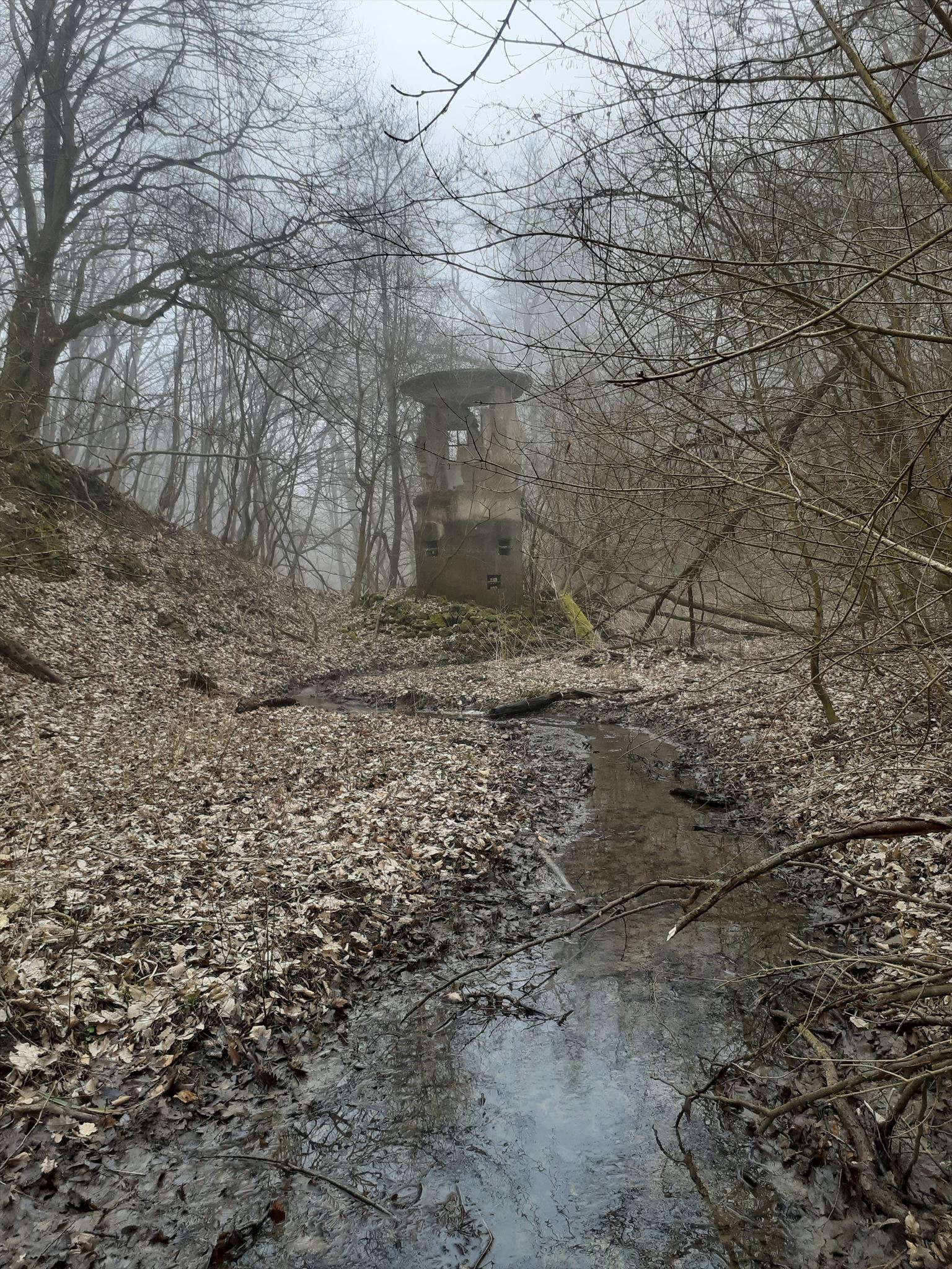
After the closing of the mine in 1993, the majority of the woodlands were privatised or came into the ownership of the forestry industry, so its forest-park function unfortunately ceased, which resulted in visible and rapid deterioration. Shrubbery spread through the forest, the paths disappeared, facilities were torn down, carried away, destroyed. We placed our geocache within the bounds of the abandoned mine, near a water tower and pump house blown up in the 80s and a fishing lake, somewhat commemorating the past and the communities of the once flourishing mining town.

LOCATION OF THE CACHE

STAGE 1 / Starting point

COORDINATES
N 46°7’58
E 18°19’21

Pécs (Somogy) – the Vashíd stop of local bus no. 14. Turning towards North-East, set off towards Szövetkezet Street (Szövetkezet utca). Find and follow the tourist route marked with a green stripe. Follow the green sign at the end of Szövetkezet Street to the forest edge.

STAGE 2 / End of Szövetkezet Street, forest edge, 16/1 sign and green stripe tourist mark on an electrical pole

COORDINATES
N _ _ °8’28
E _ _°_ _’7

We get the third and fourth digits of the eastern longitude by taking the first and third numbers of the year written on the memorial we see on the right as we walk, below the Tributarii Ferri inscription.
We get the first two digits of the eastern longitude by taking the first and third digits of the red numbers upon yellow background (108) found under the junction box on an electrical pole near the memorial.

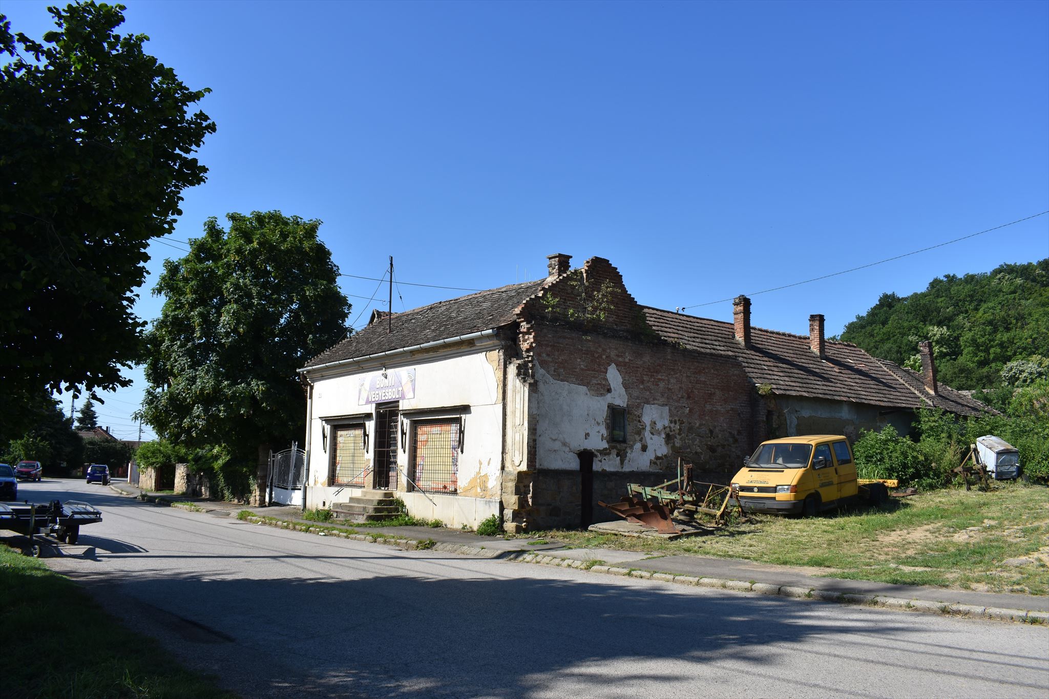
We can find the first two digits of the northern latitude on our way from the first stage, finding the house number of the house which is across the road from the one bearing the sign "vegyesbolt", once a store.

After this, we enter the forest and walk along the stream, still following the green stripe tourist sign. In rainy weather, waterproof shoes are advisable.

STAGE 3 / Old oak with green stripe tourist sign

COORDINATES
N 46°_' _ _
E 18°19’_

We can reach the third point with a 16-minute leisurely walk, crossing the stream four times and leaving two hills behind. On the right-hand side, on a large old oak, we can see a green stripe tourist sign at eye-level.
We get the third number of the northern latitude by adding three to the weight limit number seen on the traffic sign at the entrance of the forest after the second point.
The fourth digit of the northern latitude equals the weight limit number on the traffic sign at the entrance of the forest.
We get the fifth digit of the northern latitude by taking the first digit of the number on the post box of the last house before the entrance of the forest.
The last digit of the eastern longitude can be seen after about 12 minutes of walking from the forest entrance following the green tourist sign, on an old beech tree to the right, on which a forestry sign is placed: the number equals the third character of the first row.

STAGE 4 / Geocache

Motto, message, tip: „As nature takes it back” or the remnants of an abandoned mine - an environmental protection problem without recultivation. The cache is hidden in a cavity formed under the roots of the tree which has grown into the man-made staircase.
After the 3rd point, we leave the tourist path to descend steeply into the valley of the stream; the terrain is more difficult from here on. Here we can discover the remains of the mine buildings - crushed, blown-up slabs of reinforced concrete, stairs, etc.
The third digit of the northern latitude equals the number of root spears visible on the surface at the old oak of the third checkpoint.
We get the fourth digit of the northern latitude if we subtract three from the number of root spears seen on the surface at the old oak of the third checkpoint.
We get the fifth digit of the northern latitude by taking the first digit of the year found in the last row of the white forestry sign painted on the old beech before the third point.
We get the third and fourth digits of the eastern longitude by taking the last two digits of the year seen on the forestry sign and adding one to it.
We get the fifth digit of the eastern longitude by taking the first digit of the same year and multiplying it by two.


We wish you a successful quest and a nice trip!


Additional Hints (No hints available.)