Skip to content

Őskohó a természet ölelésében Multi-Cache

This cache has been archived.

MTVSZ: Helyi kapcsolat jelezte, hogy sajnos nem tudja tovább gondozni a ládát.

More
Hidden : 6/11/2023
Difficulty:
3 out of 5
Terrain:
1.5 out of 5

Size: Size:   small (small)

Join now to view geocache location details. It's free!

Watch

How Geocaching Works

Please note Use of geocaching.com services is subject to the terms and conditions in our disclaimer.

Geocache Description:


Ez a geoláda a ClimateQuest sorozat része, amely 8 európai országban 43 rejtekhelyen keresztül vezet el olyan érdekes helyekre, amelyek valamilyen módon kapcsolódnak a természetvédelemhez vagy az éghajlatváltozáshoz. Magyarországon 6 geoládát helyeztünk el, de találhatsz még Bulgáriában, Romániában, Szlovákiában, Csehországban, Németországban, Lettországban és Litvániában is.

MEGKÖZELÍTÉS

Autóval illetve kerékpárral Miskolcról
Diósgyőr városrészen keresztül Alsó – és Felsőhámor érintésével Lillafüredig, majd a Hámori tó mellett a Garadna településrész felé vezető úton az Őskohóig. Itt, a Garadna patak partján ingyenes parkoló áll az érkezők rendelkezésére.
Autóbusszal:
a Felső-Majláthról induló 15 számú busszal az Újmassa-Őskohó megállóhelyig: https://www.mvkzrt.hu/menetrend?line=15
A Lillafüredi kisvasútnak is van itt megállóhelye: "Fazola-kohó"
menetrend: https://www.laev.hu/index.php/a-laev-nyari-menetrendje

LEÍRÁS

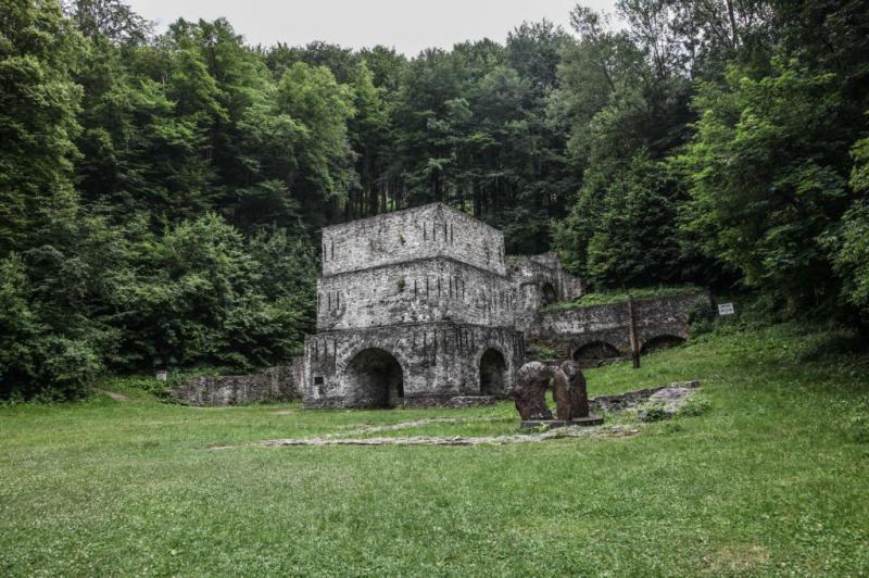
Fazola-kohó, "őskohó"

A Hámori-tó nyugati csücske és Újmassa között a Garadna-patak festői völgye őrizte meg hazánk egyetlen kohóipari műemlékét, a faszéntüzelésű nagyolvasztót, a Fazola-kohót, közismert nevén "őskohót". Az őskohóhoz hasonló ipari emlék Európában csak három található.
A kohó története a 18. századra nyúlik vissza. Fazola Henrik lakatos mester – akinek világhírű rokokó stílusú alkotásai Egerben találhatók – 1770-ben Miskolc-Ómassa területén, Mária Terézia engedélyével az általa felfedezett bányákra, illetve a térségben található hatalmas erdőségekre alapozva vasművet épített.
Fia Frigyes, aki kiemelkedő eredményeket ért el a hazai acélgyártás megteremtésében, előbb a Garadna-patak mentén 1810-1812 között megépített egy duzzasztógátat, mellyel létrejött a Hámori-tó, majd 1813-ban Újmassán egy korszerűbb kohót, vasművet telepített. A kohó, mely 1831-ben átépítésre került, az 1870-ben Miskolc és Diósgyőr között telepített vasgyár üzembe helyezése után, 1872-ben fejezte be működését.
A következő évtizedek során romba dőlt nagyolvasztót a diósgyőri kohászati üzemek hathatós támogatásával a XX. század közepén rekonstruálták, részben eredeti formájában helyreállították. Az építmény Magyarország legrégibb ipari műemlékeként vált közismertté hazánkban és határainkon túl.
A kohó mellett áll a Massa Múzeum és a műemlék vasverő. Az őskohó és a közelében található látnivalók Miskolc felől a lillafüredi kisvasúttal vagy a 15-ös autóbusszal érhető el, illetve gépkocsival Miskolc és Eger felől a Palotaszálló mellett elterülő Hámori-tónál Ómassa felé elágazó úton közelíthető meg.
Minden év szeptemberében a kohó melletti terület ad otthont a Fazola Fesztiválnak, melynek célja a térség történelmi, ipari értékeinek bemutatása, a műszaki pályák népszerűsítése és a bányász-, kohász-, erdésztársadalom összetartozásának a kifejezése. A kohó egész évben szabadon látogatható.

A Lillafüredi Pisztrángtelep

A Lillafüredi Pisztrángtelepet, a Magyar Királyi Erdőigazgatóság építette 1932-ben, a Bükk-hegység szívében a Hámori-tótól 4 kilométerre. Jelenleg a Bükki Nemzeti Park területén található gazdaság, a Garadna-völgy merész hegyfalai közt kanyargó patakra és a Margitforrás vizére települt. A gazdaság 1,0 hektáron 3700 m2 vízfelülettel, 18 medencével üzemel.
A tiszta vizű tavakban sebes pisztrángot, szivárványos pisztrángot és pataki szajblingot szaporítanak, évente fél millió ikrát keltetve.
Május 01-tõl szeptember 30-ig működik egy kis “Erdei halsütöde”, ahol megkóstolhatják a frissen kifogott halat, amit nyolc féle fűszerben, kétféle lisztben megforgatva ropogósra sütnek, vagy a füstölt pisztrángot, amit egy saját recept szerint tizenkét féle fűszerből készült páclében egy éjszakát pácolnak, és hideg füstön, bükkfa hasábon, és fűrészporon aranysárgára füstölnek, és átmelegítve tálalnak.
A Garadna-patak, amelynek medre 0,2-1 m mély, 1,5-2,5 m széles, zúgókkal, bedőlt fákkal négy-nyolc kilométer hosszan horgászási lehetőséget is biztosít a pisztránghorgászat szerelmeseinek. Területi engedélyt a pisztrángtelepen lehet váltani.
A pisztrángtelepen a termelés mellett takarmányozási, keresztezési kutatásokat, valamint a megye vizeinek halfaunisztikai, ökológiai felmérését és szaktanácsadást is végeznek. A telep egész évben megtekinthető.

Nyavalyás-hegyi dolomitbánya

Több mint 20 éve felhagyott, 7 szintes dolomitbánya. Azelőtt a Diósgyőri Kohászat kőbányája volt. A Pisztrángtelep felett magasodik egészen a Nyavajás-hegy tetejéig. A bányafalak veszélyesek, amit az alattuk felgyülemlett friss dolomit-törmelék is mutat. A nyavalyás-tetői bánya négy fejtési szintjét már nem művelik. A kitermelt nyersanyag sötétszürke, kalciteres dolomit volt, melyet a kohászat hasznosított. A felhagyást követően a nyolcvanas évek végén a területet rendezték, a meddőhányót fákkal beültették.
A Nyavalyás-tetőt nyugatról a Tekenős-völgy, északról a Garadna-völgy, keletről a Savós-völgy, délről a Szárdóka-gerinc határolja. A Nyavalyás-tető fennsíkperemi, allogén karsztterület. Vízgyűjtő területe a Szárdóka-gerinc (660 méter tszf.), erózióbázisa a Garadna-völgy (350 méter tszf.). A Nyavalyás-tető morfológiai jellegét a változatos kőzettani viszonyok, és a fennsíkperemi helyzete határozzák meg.

A LÁDA REJTEKHELYE

1. ÁLLOMÁS / KIINDULÓPONT
A megadott koordináta a kiinduló pont:

KOORDINÁTA
N 48°6.853’
E 20°35.288’

A patakon lévő gyalogos hídon átkelve jutunk el az Őskohóhoz. (kb. 88m) Itt további információhoz lehet jutni, ami iránymutatásul szolgál a második pont megtalálásához.

2. ÁLLOMÁS
A második ponton található információ alapján lehet majd megtalálni a harmadik pontot, mely elvezet egy újabb állomásra.

Fedezd fel az Őskohó környékét!
Nézd át az Őskohón és a Massa-múzeumon található információs – és emlék táblákat. Az a tábla mellyel a „HATALMAS MÜ DOLGOZOI” állítanak emléket az alapítóknak, fontos információkat hordoz, ugyanis ez a szöveg rejti a 3. pont koordinátáit.

1) A szöveg első bekezdésének minden 3. betűje egy számot jelöl. A megoldó kulcs segítségével fejtsd meg az északi koordináta számjegyeit.

KOORDINÁTA
N _ _° _ . _ _ _

Dekódoló kulcs az északi koordinátához:

A B C I G R É V P F H
1 2 3 4 8 6 7 9 9 5 0

(A felső betű megfelel az alsó számnak)

2) A szöveg második bekezdésének minden 2. betűje egy számot jelöl. A megoldó kulcs segítségével fejtsd meg az keleti koordináta számjegyeit.

KOORDINÁTA
E _ _° _ _ . _ _ _

Dekódoló kulcs a keleti koordinátához:

A B C M S Z V L D E
4 1 5 0 3 2 7 4 6 8

(A felső betű megfelel az alsó számnak)

Séta közben megfigyelheted a meanderező Garadna-patak érintetlen növény – és állatvilágát. Ha teheted, vigyél magaddal növény –és állathatározót. A séta ezen része a kék + jelzésen vezet az aszfaltút szélén.

3. ÁLLOMÁS
A dekódoló kulcs segítségével megfejtett koordináta pontján fontos „infókat” kapsz a következő állomás megtalálásához (keresd az éhes sárga halacskát) és jól nézz körül! Nézd meg a halat, valamint a körülötte lévő információkat, mert a következő ponton ezek segít majd az utolsó koordináta megfejtéséhez. Itt találsz segítségül egy kis információs táblát, hogy melyik irányba, s mit keress a következő pont megfejtéséhez!
Az aszfalt úton tovább haladva a kék + jelzés mentén a drótkerítés mellet balra lesz egy földút, elágazás befelé az erdőbe, ahol hamarosan egy sorompó állja az utunkat. Ezen a ponton egy újabb „információs táblát” találsz, melyen az utolsó ponthoz kapsz útmutatást.
OLVASD EL AZ INFORMÁCIÓS TÁBLÁT (1)
Ezután átkelünk a sorompón, majd a patakon és követjük a bányába vezető utat. Innen kezd emelkedni az út, eddig lehet biciklivel is jönni. Az út első szakasza „szelíden” emelkedik. Ahhoz, hogy a negyedik ponton elrejtett koordinátát megtaláld, természetesen jó helyen kell hozzá lenned. Egy rövidebb emelkedő szakasz után újabb információs táblát találsz balra 2 juharfa között. Itt letekintve a völgybe láthatod a Pisztrángtelep medencéit. Innen már nincs sok hátra. Haladj tovább egyenesen.
OLVASD EL AZ INFORMÁCIÓS TÁBLÁT (2)

4. ÁLLOMÁS
Itt a láda! Bánya előtti fa információs tábla. Itt megtalálod a láda rejtekhelyét pontosító információkat.
OLVASD EL AZ INFORMÁCIÓS TÁBLÁT (3)


Kérem, hogy gondosan rejtsétek vissza és álcázzátok a ládát, hogy az állatok illetve az esetleges túrázók ne férhessenek könnyen hozzá.

Eredményes keresést és kellemes kirándulást kívánunk!


FORRÁS


The cache is part of the ClimateQuest series of 43 caches in 8 European countries, six of which are located in Hungary, the rest in Germany, Czech Republic, Slovakia, Bulgaria, Romania, Lithuania and Latvia. In Hungary, these caches will take you to interesting places that are somehow connected with nature conservation or climate change.

ACCESS

By car and by bicycle from Miskolc
Go through Diósgyőr, then pass through Alsó- and Felsőhámor to Lillafüred. Then go along Lake Hámor on the way to the village Garadna to the Őskohó. Here, free parking is available on the banks of the Garadna stream.
By bus
we can get on the bus no. 15 from Felső-Majlát and get off at Újmassa-Őskohó station. Bus schedule: https://www.mvkzrt.hu/menetrend?line=15
Lillafüred State Forest Railway also has a station here called: "Fazola-kohó"
Check out the timetable here: https://www.laev.hu/index.php/a-laev-nyari-menetrendje

DESCRIPTION

Fazola-kohó, "ancient furnace"

Between the western tip of Lake Hámori and Újmassa, the picturesque valley of the Garadna stream preserves the only metallurgical monument in Hungary, a blast furnace called Fazola-Kohó, commonly known as "ancient furnace". There are only three industrial monuments like this in Europe.
The history of the blast furnace dates back to the 18th century. The blacksmith Heinrich Fassola - whose world-famous Rococo works can be found in Eger - built a blast furnace in 1770 in the Miskolc-Ómassa area with the permission of Queen Maria Theresia, using the mines he had discovered and the vast forests in the area.
His son Frigyes, who achieved outstanding results in the creation of domestic steel production, first built a dam along the Garadna stream between 1810 and 1812, which created Lake Hamori, and then in 1813 he installed a more modern blast furnace and ironworks in Újmassa. The blast furnace was closed in 1872 after the new iron factory had been established in 1870 between Miskolc and Diósgyőr.
The blast furnace, which fell into ruins in the following decades, was reconstructed in the middle of the 20th century with the effective support of the Diósgyőr factory, and partially restored to its original form. The building has become known in Hungary and beyond as the oldest industrial monument in the country.
Next to the furnace are the Massa Museum and the historic monument of iron forging. You can get to the smelter and its nearby sights from Miskolc by the Lillafüred forest railway or bus no. 15, or by car from Miskolc and Eger on the road forking towards Ómassa at Lake Hámori near the Palotaszálló.
Every year in September, the area next to the furnace hosts the Fazola Festival, which aims to showcase the historical and industrial values of the area, promote industrial engineer careers and express the solidarity of the mining, metallurgical, and forging communities. The smelter is open to the public all year round.

The Trout Breeding Farm in Lillafüred

The Hungarian Royal Forest Administration ordered to build of the farm in 1932 at the heart of the Bükk Mountains, 4 kilometers from Lake Hámori. Currently, the farm is located in the Bükk National Park, on a stream meandering between the bold mountain walls of the Garadna Valley and filled with water from the Margaret Spring. The farm operates on 1.0 hectares, 3700 m2 of water, and 18 pools. In the freshwater ponds, you can see brown trout, rainbow trout, and brook trout, each of which lays about half a million eggs a year.
From May 1st to September 30th, there is a small "Forest Fish Market" where you can taste freshly caught fish, fried in eight different spices and two kinds of flour, or smoked trout. The latter is marinated overnight in a marinade of twelve spices then cold smoked using beechwood logs, and sawdust until golden brown, and served reheated. Both are based on their own traditional recipes.
The Garadna Stream is 0.2-1 m deep and 1.5-2.5 m wide, with rapids and fallen trees, offering trout fishing for four to eight kilometers. You can buy a license at the trout farm.
In addition to production, the trout farm also carries out feeding and cross-breeding research, fish faunistic, and ecological research of the county's waters and provides expert advice. The farm can be visited all year round.

Dolomite quarry of Nyavalyás-hegy

A 7-level dolomite mine abandoned for more than 20 years. It was formerly the quarry of Diósgyőri Kohászat. It rises above the Trout Breeding Farm up to the top of Nyavalyás Hill. The walls of the mine are dangerous, as shown by the fresh dolomite debris accumulated at the foot of the wall. The four levels of the Nyavalyás-Tető mine are no longer in operation. The extracted raw material was dark grey calcitic dolomite, which was exploited in metallurgy. After the abandonment in the late 1980s, the area was cleared and the mound was planted with trees.
The Nyavalyás-tető is bordered by the Tekenős Valley to the west, the Garadna Valley to the north, the Savós Valley to the east, and the Szárdóka Ridge to the south. Nyavalyás-tető is a plateau ridge, allogenic karst area. Its water catchment area is the Szárdóka Ridge (660 m a.s.l.) and its erosion base is the Garadna Valley (350 m a.s.l.). The morphological character of Nyavalyás-Tető is determined by the varied rock formations and their position on the plateau ridge.

LOCATION OF THE CACHE

STAGE 1 / Starting point
This coordinate is the starting point:

COORDINATES
N 48°6.853’
E 20°35.288’

Cross the footbridge over the stream and you will reach Őskohó (approx. 88m) Here you can find more information to guide you to the second point.

STAGE 2
The information at the second point will help you to find the third point, which will lead you to another station.
Explore the blast-furnace area! Check out the information and commemorative plaques on the blast furnace and the Massa Museum. The plaque commemorating the founders with the inscription "HATALMAS MÜ DOLGOZOI" contains the coordinates of the third point.

1) Every 3rd letter of the first paragraph of the text represents a number. Use the decoding key to decipher the digits of the north coordinate.

COORDINATE
N _ _° _ . _ _ _

The decoding key for the north coordinate:

A B C I G R É V P F H
1 2 3 4 8 6 7 9 9 5 0

(The upper letter corresponds to the lower number)

2) Every 2nd letter of the second paragraph of the text represents a number. Use the decoding key to decipher the digits of the eastern coordinate.

COORDINATE
E _ _° _ _ . _ _ _

The decoding key for the eastern coordinate:

A B C M S Z V L D E
4 1 5 0 3 2 7 4 6 8

(The upper letter corresponds to the lower number)

On your walk, you can observe the pristine flora and fauna of the meandering Garadna stream. If you can, take a plant and animal guide with you. This part of the walk follows the blue + sign along the tarmac road.

STAGE 3
At this stage, you will find important information for the next point (search for the hungry yellow fish) and take a good look around! Look at the fish and the information around it because, at the next point, it will help you to decipher the coordinate of the cache. There is a small information board that helps you to find the right direction and what to look for to decipher the next point!br>Continuing along the asphalt road following the blue + sign, you will see a dirt road on the left, next to a wire fence, forking off into the forest, where you will arrive at a gate. At this point, you will find another 'information sign' giving you directions to the last point.
READ THE INFORMATION BOARD (1)
Cross the gate, then the stream, and follow the road to the mine. From here the road starts to climb. You can cycle up to this point. The first part of the road climbs gently. After a short uphill section, you will find another information sign on the left between 2 maple trees. Here you can look down into the valley and see the pools of the Trout Farm. It’s not much further from here. Continue straight ahead.
READ THE INFORMATION BOARD (2)

STAGE 4
Here is the cache! There is a wooden information sign in front of the mine. Here you will find information specifying the hiding place of the cache.
READ THE INFORMATION BOARD (3)


Please hide and camouflage the cache so that animals or potential hikers cannot easily access it.

We wish you a successful quest and a nice trip!


SOURCE


Additional Hints (No hints available.)