Paredes de Anaga
El macizo de Anaga es una formación
montañosa y región histórica del nordeste de la isla canaria de
Tenerife. Es el lugar que cuenta con mayor cantidad de endemismos de
Europa y por eso en 1994 fue declarado como parque rural de Anaga y el
9 de junio de 2015 como reserva de la biosfera por la Unesco. Debido a
la antigüedad de sus materiales (5,7 millones de años), a la elevada
alteración de los mismos y a la densa red de diques que atraviesan el
macizo, se han dejado en resalte numerosos roques, tanto de origen
fonolítico como traquítico. Destaca el Pico del Inglés como mayor
altitud, con 1.024 m.
No olvidemos que estamos en una isla de orígen volcánico. El edificio
de Anaga se constituye a partir de apilamiento de materiales de origen
volcánico. La litología más abundante viene dada por el grupo de los
basaltos (piroclastos y coladas), también aparecen coladas fonolíticas
y aglomerados de la misma naturaleza. Las rocas plutónicas están poco
representadas y las sedimentarias, más abundantes, son de tipo
detrítico y se relacionan con procesos erosivos continentales y marinos.
El macizo de Anaga está situado en un edificio volcánico formado por
lavas dominantemente basálticas, que se formó por la sucesión de
múltiples episodios, donde los procesos erosivos han determinado un
paisaje dominado por una profunda red de barrancos.
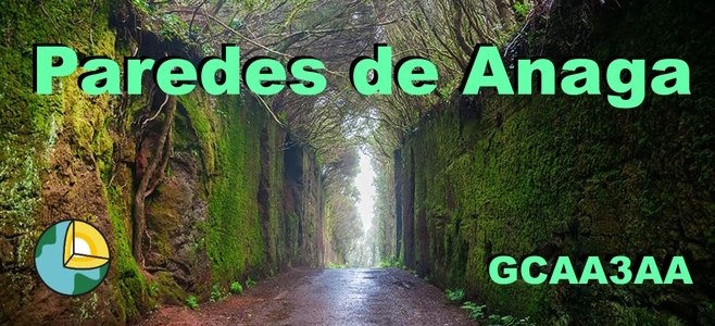
Camino al Pico del Inglés, podemos visitar las Paredes de Anaga
(también conocidas cono el túnel de hadas). Un corte literal de la
montaña, de las más antiguas de la isla, donde las paredes rocosas
están verdes, húmedas y con raíces.
Con este Earthcache queremos que visitéis este mágico lugar y observéis
detenidamente las paredes rocosas.
PREGUNTAS
Para poder registrar como
encontrado este Earthcache, nos tenéis que mandar un correo (podéis
hacerlo
desde nuestro perfil de usuario) con las respuestas a las siguientes
preguntas. Podéis loguear el earthcache sin haber recibido
nuestra respuesta. Si no recibimos el correo con las respuestas
correctas, el log podrá ser borrado sin previo aviso.
1.- Cuál de las
siguientes afirmaciones es correcta:
A) Las paredes son artificiales, de cemento y recubiertas de
vegetación.
B) Las paredes son de orígen volcánico, compuestas de rocas
basálticas.
C) Las paredes fueron originadas por la erosión del río que pasaba
antiguamente por aquí.
D) Las paredes fueron creadas por Guayota, el diablo del Teide.
2.-
Observa de cerca las rocas de las paredes. Explica con tus palabras qué
textura
tienen, qué color y por qué crees que tienen este color.
3.
¿Crees que las paredes llegarán a derrumbarse?
Razona tu respuesta.
4.-
FOTO. Hazte una fotografía en las Paredes de
Anaga. Si no quieres salir,
un papel
con tu nick o tu GPS será válido. Recuerda que esta fotografía es
OBLIGATORIA para demostrar que has visitado este Earthcache.
Si no recibimos las respuestas, el log será
borrado sin previo aviso.
También podrán ser borrados todos los
logs que no incluyan la fotografía obligatoria de la pregunta 4 (desde
la actualización de las guidelines de junio de 2019, la fotografía
puede ser obligatoria para demostrar que se ha visitado el sitio).
No
olvides que estás dentro de un entorno natural, hay que respetarlo y
cuidarlo.
Gracias por vuestra
comprensión y esperemos que disfrutéis del lugar.

ENGLISH VERSION
Anaga Walls (ENG)
The
Anaga massif is a mountainous formation and historical region in the
northeast of the Canary Island of Tenerife. It is the place with the
largest number of endemic species in Europe and that is why in 1994 it
was declared an Anaga rural park and on June 9, 2015 as a biosphere
reserve by Unesco. Due to the antiquity of its materials (5.7 million
years), to the high degree of alteration of the same and to the dense
network of dikes that cross the massif, numerous rocks have been left
in prominence, both of phonolitic and trachytic origin. The Pico del
Inglés stands out as the highest altitude, with 1,024 m.
Let's not forget that we are on an island of volcanic origin. The Anaga
massif is made from a stack of materials of volcanic origin. The most
abundant lithology is given by the group of basalts (pyroclastic and
flow), there are also phonolitic flows and agglomerates of the same
nature. Plutonic rocks are poorly represented and the most abundant
sedimentary rocks are of the detrital type and are related to
continental and marine erosive processes.
The Anaga massif is located in a volcanic edifice formed by
predominantly basaltic lavas, which was formed by the succession of
multiple episodes, where erosive processes have determined a landscape
dominated by a deep network of ravines.
On the way to Pico del Inglés, we can visit the Paredes de Anaga (Anaga
Walls, also known as the fairy tunnel). A literal cut of the mountain,
one of the oldest on the island, where the rocky walls are green, humid
and rooted.
With this Earthcache we want you to visit this magical place and take a
close look at the rocky walls.
QUESTIONS
In order to register as a found this Earthcache, you
have to send us an email (you can do it from our user profile) with the
answers to the following questions. You can log the earthcache
without having received our response. If we do not receive the email
with the correct answers, the log may be deleted without prior notice.
1.- Which of the following statements is correct:
A) The walls are artificial, made of cement and covered with vegetation.
B) The walls are of volcanic origin, composed of basaltic rocks.
C) The walls were created by the erosion of the river that used to pass
through here.
D) The walls were created by Guayota, the devil of Teide.
2.- Look closely at the rocks on the walls. Explain in your own words
what texture they have, what color and why do you think they have this
color.
3.- Do you think the walls will come crashing down? Reason
your answer.
4.- PHOTO. Take a picture of yourself with the Anaga
Walls. If
you don't want to appear, a piece of paper with your nickname or your
GPS will be ok. Remember this photograph is REQUIRED to prove that you
have visited this Earthcache.
If we don't receive the answers, the log
will be deleted without prior notice.
All logs that do not include the
required photograph in question 4 may also be deleted (since update of
the guidelines in June 2019, the photograph may be required to prove
that the place has been visited).
Don't
forget you are in a natural environment, you have to respect it and
take care of it.
Thank
you for your understanding and we hope you enjoy the place.