

Cette cache a été posée à l'occasion du Mega évent "Au Front" à Givenchy-en-Gohelle GCA9YTX. Ce rassemblement a été voulu par les organisateurs comme un moment de convivalité entre passionés de Geocaching, de nature, de patrimoine et d'histoire. Notre volonté est de permettre à chaque profil de joueur de pouvoir pratiquer ce loisir comme il le souhaite et de partager avec d'autres des moments de rassemblement et de partage autour de sites historiques du Nord-Pas-de-Calais.
Stratification(s)
Cette Earth Cache a pour but de vous faire (re)découvrir la sédimentation.
🧰 Pour répondre aux questions sur place, un mètre ou un décimètre vous sera utile.
📌 Questions
- 1 : Observez l'ensemble du bloc (zones A et B), de quel type de stratification s'agit-il et pourquoi? Attention, le bloc dans la construction est à l'envers, il vous faudra pencher la tête!
- 2 : La zone B correspond à une petite dune hydraulique. Mesurez la taille des éléments au point B1 et au point B2; en consultant le diagramme d'Hjulström, quelle était la vitesse maximale du courant pour qu'il y ait dépôt pour ces deux points (attention, l'échelle est logarithmique)?
- 3 : Associez les points B1 et B2 avec le versant aval et le versant amont. Qu'est ce qui vous permet de l'affirmer?
- 4 : Une photo de vous ou d'un objet vous représentant, devant la porte de la chapelle, est obligatoire pour valider cette Earth Cache.
Le dépôt des sédiments
Le dépôt des sédiments a lieu lorsque la vitesse de l'agent de transport diminue ou lorsque cet agent de transport disparaît (fonte de la glace par exemple). La granulométrie des particules, la texture des sédiments, la géométrie des dépôts sont d'importants indices sur l'agent de transport, sa vitesse au moment du dépôt, sa direction, etc.
Le diagramme de Hjulström illustre le comportement des particules en fonction de leur taille et de la vitesse du courant.
Diagramme de Hjulström 🔽

Granulométrie des sédiments
La granulométrie d'un sédiment renseigne évidemment sur la nature et la vitesse de l'agent de transport. Il faut cependant tenir compte d'un élément important: le stock sédimentaire disponible à la source. Pour prendre un exemple, on pourrait observer un dépôt de sable très bien trié, dû non pas aux caractéristiques de l'agent de transport, mais tout simplement au fait que c'était le seul matériau disponible dans le bassin de sédimentation. On peut donc dire que quelle que soit la capacité de transport des courants , ils ne pourront pas véhiculer de grains plus grossiers que ceux disponibles à la source.
La granulométrie 🔽

Le granoclassement
Un caractère important des sédiments est la présence éventuelle de granoclassement. On distingue le granoclassement normal où les sédiments deviennent de plus en plus fins vers le haut et le granoclassement inverse où les sédiments sont de plus en plus grossiers vers le haut. Ces phénomènes sont évidemment liés à la diminution ou l'augmentation progressive de la capacité de transport des courants. Ils sont fréquents et bien développés dans les turbidites et dans les dépôts de fin de crue.
Le granoclassement 🔽

Les dunes hydrauliques
L'édification d'une dune hydraulique se réalise de façon progradante (avancée progressive vers le large) dans le sens du courant. De fines couches obliques (= foresets) se déposent par avalanche à l'aval du courant, en progressant sur une semelle basale formée de particules déposées par décantation, en avant de la dune. Chaque lamine oblique est ensuite recouverte d'une pellicule de particules transportées depuis le versant amont de la dune. Une succession de lamines obliques d'épaisseur millimétrique constitue un lit d'épaisseur centimétrique à décimétrique. L'accumulation peut se faire sur quelques dizaines de centimètres, mais aussi sur des kilomètres en largeur et jusqu'à une dizaine de kilomètres en longueur.
Formation des dunes hydrauliques 🔽

La stratification
Le dépôt des différents éléments transportés par les courants va composer la structure interne du sédiment. Voici quelques exemples de stratification.
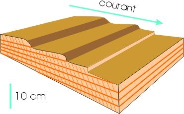
Les stratifications obliques sont créées par des courants de direction constante.
Stratifications obliques 🔽
Les stratifications en arêtes de poisson sont caractérisées par la superposition de lamines obliques de sens opposé. Cette structure est produite surtout lors des inversions périodiques des courants de marée, notamment à proximité des estuaires.
Stratifications en arêtes de poisson 🔽

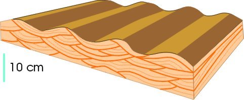
Les stratifications entrecroisées de rides de vagues sont de taille centimétrique et sont formées par les vagues.
Stratifications entrecroisées 🔽
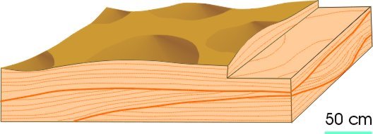
Les stratifications en mamelon, généralement à l'échelle du mètre, sont caractérisées par de larges ondulations, faiblement inclinées (souvent moins de 15°). Ce type de stratification entrecroisée est généré par des vagues de tempête.
Stratifications en mamelon 🔽
Sources
- Wikipedia
- coursgeologie.com
- Dictionnaire de Géologie, d'Alain Foucault, Jean-François Raoult, Bernard Platevoet et Fabrizio Cecca, Dunod, 9ème édition, 2020
- Sédimentologie, d'Isabelle Cojan et Maurice Renard, Dunod, 2ème édition, 2006
Comment valider cette Earth Cache
Petit rappel concernant les "Earth Caches": il n'y a pas de contenant à rechercher, ni de logbook. Il suffit de se rendre sur les lieux, de répondre aux questions ci-dessous. Vous pouvez loger en "Found it" et envoyez-moi vos propositions de réponses, soit via mon profil, soit via la messagerie geocaching.com (Message Center), et je vous contacterai en cas de problème.
Localisation


📌 Rappel des questions
- 1 : Observez l'ensemble du bloc (zones A et B), de quel type de stratification s'agit-il et pourquoi? Attention, le bloc dans la construction est à l'envers, il vous faudra pencher la tête!
- 2 : La zone B correspond à une petite dune hydraulique. Mesurez la taille des éléments au point B1 et au point B2; en consultant le diagramme d'Hjulström, quelle était la vitesse maximale du courant pour qu'il y ait dépôt pour ces deux points (attention, l'échelle est logarithmique)?
- 3 : Associez les points B1 et B2 avec le versant aval et le versant amont. Qu'est ce qui vous permet de l'affirmer?
- 4 : Une photo de vous ou d'un objet vous représentant, devant la porte de la chapelle, est obligatoire pour valider cette Earth Cache.
Merci par avance de ne pas poster de photo spoiler dans vos logs! 🙂
Bon Geocaching!


This cache was installed at the "Au Front" mega event in Givenchy-en-Gohelle GCA9YTX. The organisers wanted this gathering to be a convivial occasion for people who are passionate about Geocaching, nature, heritage and history. Our aim is to enable every profile of player to enjoy this hobby as they wish, and to share with others moments of gathering and sharing around historic sites in the Nord-Pas-de-Calais region.
Stratification(s)
This Earth Cache aims to make you (re)discover sedimentation.
🧰 You'll need a metre or decimetre to answer questions on the spot.
📌 Questions
- 1 : Look at the block as a whole (zones A and B). What type of stratification is it and why? Be careful, the block in the construction is upside down, so you'll have to tilt your head!
- 2 : Zone B is a small hydraulic dune. Measure the size of the elements at points B1 and B2; using the Hjulström diagram, what was the maximum current speed for deposition at these two points (note that the scale is logarithmic)?
- 3 : Associate points B1 and B2 with the downstream slope and the upstream slope. How can you tell?
- 4 : A photo of yourself or an object representing you, in front of the chapel door, is mandatory to validate this Earth Cache.
Sediment deposition
Sediment is deposited when the speed of the transport agent decreases or when the transport agent disappears (melting ice, for example). Particle size, sediment texture and the geometry of deposits are important clues to the transport agent, its speed at the time of deposition, its direction, etc.
The Hjulström diagram illustrates the behaviour of particles as a function of their size and current speed.
Hjulström diagram 🔽

Sediment grain size
The grain size of a sediment obviously provides information about the nature and speed of the transport agent. However, an important factor must be taken into account: the sediment stock available at the source. To take an example, we might observe a deposit of very well sorted sand, due not to the characteristics of the transport agent, but simply to the fact that it was the only material available in the sedimentation basin. We can therefore say that whatever the transport capacity of the currents, they will not be able to carry coarser grains than those available at the source.
Granulometry 🔽

Granoclassing
An important characteristic of sediments is the possible presence of granoclassing. A distinction is made between normal granoclassing, where the sediment becomes finer and finer towards the top, and reverse granoclassing, where the sediment becomes coarser and coarser towards the top. These phenomena are obviously linked to the gradual decrease or increase in the transport capacity of currents. They are frequent and well developed in turbidites and in deposits at the end of flood periods.
Granoclassing 🔽

Hydraulic dunes
A hydraulic dune is built up in a prograding manner (progressive advance towards the open sea) in the direction of the current. Thin oblique layers (= foresets) are deposited by avalanche downstream of the current, progressing over a basal sole formed by particles deposited by decantation, in front of the dune. Each oblique lamina is then covered by a film of particles transported from the upstream slope of the dune. A succession of oblique laminae of millimetre thickness forms a bed of centimetre to decimetre thickness. Accumulation can take place over a few tens of centimetres, but also over kilometres in width and up to ten kilometres in length.
Formation of hydraulic dunes 🔽
Stratification
The deposition of the various elements transported by the currents will make up the internal structure of the sediment. Here are a few examples of stratification.
Oblique stratification is created by currents flowing in a constant direction.
Oblique stratifications 🔽
Fishbone stratification is characterised by the superposition of oblique laminae in opposite directions. This structure is produced mainly during periodic reversals of tidal currents, particularly near estuaries.
Fishbone stratification 🔽
The criss-crossing stratifications of wave ripples are centimetre-sized and formed by the waves.
Criss-crossing stratifications 🔽
Hilly stratification, generally on a metre scale, is characterised by wide, gently sloping undulations (often less than 15°). This type of intersecting stratification is generated by storm waves.
Hilly stratification 🔽
References
- Wikipedia
- coursgeologie.com
- Dictionnaire de Géologie, d'Alain Foucault, Jean-François Raoult, Bernard Platevoet et Fabrizio Cecca, Dunod, 9ème édition, 2020
- Sédimentologie, d'Isabelle Cojan et Maurice Renard, Dunod, 2ème édition, 2006
How to validate this Earth Cache
A reminder about the "Earth Caches": there is no container to look for, nor a logbook. You just have to go to the place and answer the questions below. You can log in "Found it" and send me your suggestions for answers, either via my profile, or via the geocaching.com message center, and I will contact you if there is a problem.
Location
📌 Reminder of questions
- 1 : Look at the block as a whole (zones A and B). What type of stratification is it and why? Be careful, the block in the construction is upside down, so you'll have to tilt your head!
- 2 : Zone B is a small hydraulic dune. Measure the size of the elements at points B1 and B2; using the Hjulström diagram, what was the maximum current speed for deposition at these two points (note that the scale is logarithmic)?
- 3 : Associate points B1 and B2 with the downstream slope and the upstream slope. How can you tell?
- 4 : A photo of yourself or an object representing you, in front of the chapel door, is mandatory to validate this Earth Cache.
Thank you in advance for not posting spoilers in your logs! 🙂
Happy Geocaching!