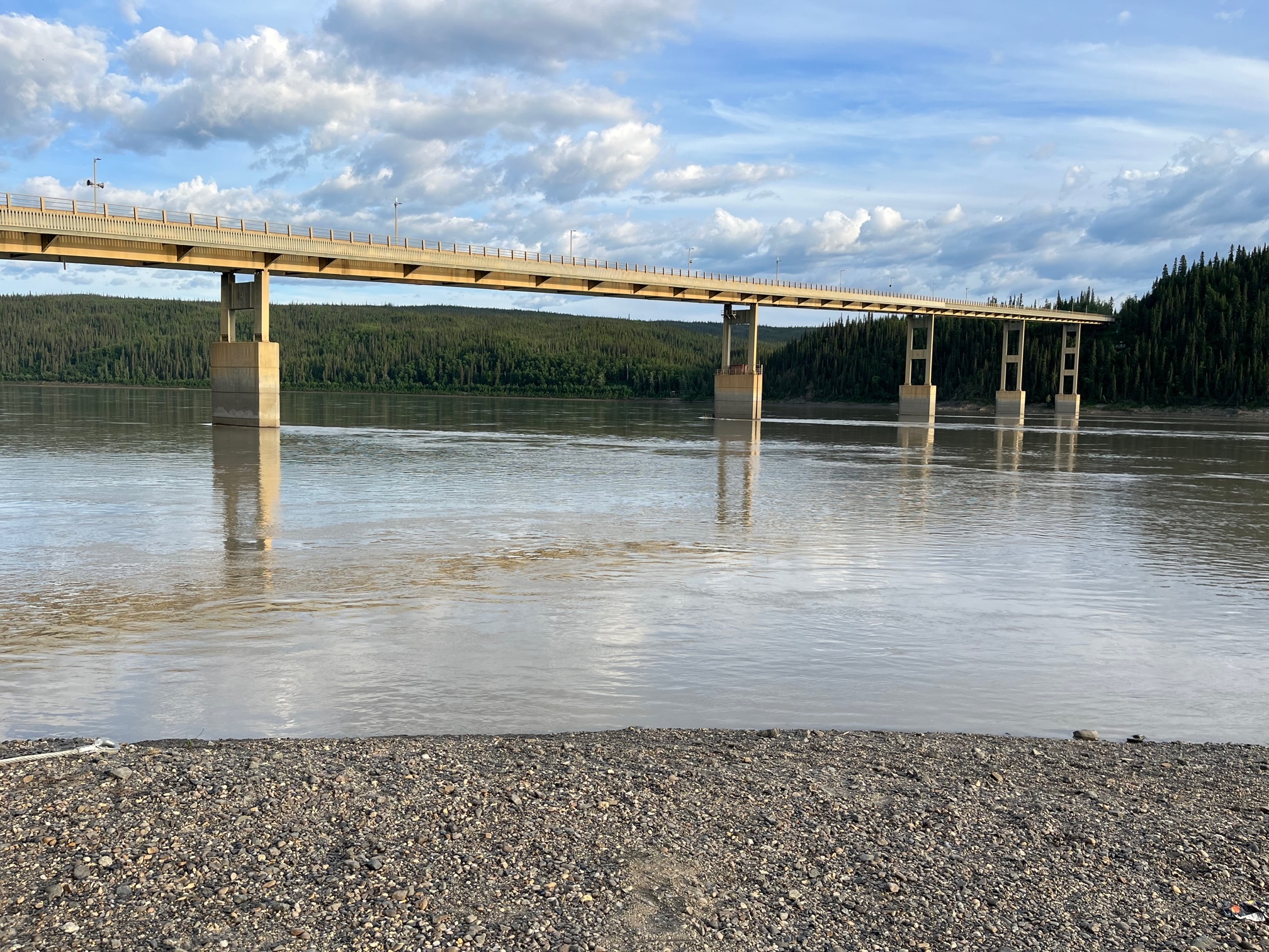
Flowing through the heart of Alaska, the Yukon River stands as a majestic and vital lifeline, etching its way across the expansive wilderness. With its headwaters in Canada's Yukon Territory, this iconic waterway travels over 1,980 miles, with a substantial portion of its course meandering through Alaska. Renowned for its untamed beauty and historical significance, the Alaska section of the Yukon River embodies the spirit of the Last Frontier, captivating adventurers and nature enthusiasts alike. The only bridge spanning this mighty river within the state of Alaska is located in front of you, on the Dalton Highway, serving as a crucial connection for travelers navigating the rugged Alaskan terrain.

River channel patterns can vary widely, showcasing the diverse ways in which water carves its path through the landscape. One common channel pattern is the straight pattern, where a river flows in a relatively straight line. This pattern is often observed in steep terrain or where the river has sufficient energy to erode and transport sediment efficiently. Meandering patterns, on the other hand, feature graceful, sinuous curves as the river winds its way across the land. These patterns commonly occur in low-gradient areas and are characterized by pronounced bends and looping curves. Braided patterns manifest as a network of interconnected channels, often seen in areas with high sediment load or significant fluctuations in flow. These channels split and rejoin, forming intricate patterns reminiscent of a braided hair. Finally, anastomosing patterns involve multiple, smaller channels branching and rejoining within a single floodplain. These patterns are typically found in areas with low gradients and abundant vegetation. Each river channel pattern exhibits its unique characteristics, reflecting the interplay between water, sediment, and the surrounding landscape.
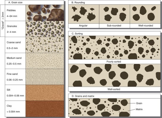
The Wentworth scale classifies sediments based on their size, providing valuable insights into geological processes and river dynamics. Larger particles such as boulders and cobbles indicate high energy environments, where rivers possess enough force to transport and deposit these coarse sediments. These larger particles are typically found in areas with steep gradients or during periods of intense flooding. Pebbles and granules, being smaller but still visible to the naked eye, are often associated with moderate-energy river settings. They can be transported during high flow events and are commonly found along riverbanks and in gravel bars. Sands, ranging in size from 0.0625 to 2 millimeters, represent the intermediate range of sediment sizes and dominate riverbeds. Their size allows for efficient transport, and their distribution within a river system can provide clues about flow velocity and channel morphology. Silt particles, finer than sands, can remain suspended in water for extended periods, and their presence in river systems indicates low-energy environments where sedimentation rates are reduced. Lastly, clay particles, the smallest on the scale, tend to settle in calm water, contributing to the fine-grained sediment layers found in floodplains and estuaries. By analyzing the size and distribution of sediment particles in rivers, geologists can infer past flow conditions and better understand the processes that shape our planet's landscapes.
Logging Requirements:
- Describe the section of the Yukon River in front of you. How many channels do you see? Is the river straight? Based on the description, what is the channel pattern of this stretch of the Yukon River? What can this tell us about the energy environment?
- Compare and contrast this side of the river with the opposite river bank. How do you think the river might change over time?
- Examine the sediment at the edge of the river. Based on the Wentworth scale, what would you classify it as? How would you classify the rounding and sorting?
- Is the water in the Yukon River clear or cloudy? What can this tell us about the presence of silt?
- Upload a photo of the Yukon River with the bridge in the background. You don't have to be in the photo, though it is strongly encouraged.
Sources:
- https://www.alaska.org/detail/yukon-river1#:~:text=The%20Yukon%20is%20so%20long,and%20900%20miles%20in%20Canada.
- https://wildearthlab.com/2023/04/12/channel-types/
- https://www.nps.gov/teachers/classrooms/sediment-sorting.htm