This Earthcache was created for all travelers heading south on I-95, especially those attending Geocoinfest Daytona 2023!
Understanding your current location in geologic terms.
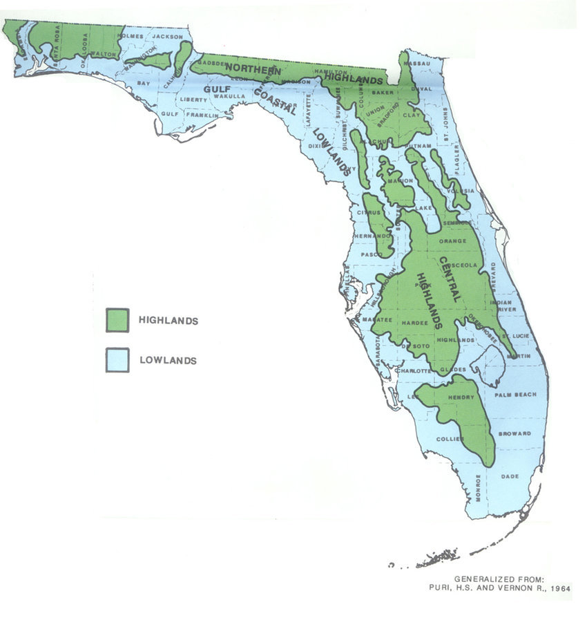
The area where you are standing is part of Florida's coastal lowlands. This entire area was underwater during the Pleistocene Era, when the underlying limestone layer that exists under the entire Florida peninsula was covered by sand and silt deposited by tidal action for millions of years. While most of Florida's present coastline was shaped the same way, the county you're in, St. Johns County, is lower in elevation than neighboring Clay County to the west.
Soil types in this area
There are two predominant soil types that are unique to this area:
- St. Johns type series of soil, an Alaquod (Spodosol) is predominant in this region and can be found from southern Duval County (Jacksonville) to as far south as Fort Drum in Okeechobee County. It can also be found throughout the state in large areas.

- St. Augustine type series of soil, an Udipsamment (Entisol) which can be found in patches throughout St. Johns County and as far south as Volusia county. It can also be found in scattered areas throughout the state, but in lesser quantity than the St. Johns type.
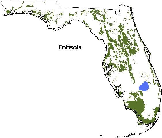
Both of these types of soil are similar in composition. often the only way to tell them apart without a molecular scan is by color: St. Johns type tends to be tan and dark, sometimes completely black; while St. Augustine type tends to be mostly brownish in color. Of these two types, St. Johns type soil is preferred for agriculture, while St. Augustine Type is preferred for construction uses. These two soil types, along with a few others including Myakka (the official State Soil) and Florida type soils are predominant throughout the Florida peninsula but harder to find in the Florida panhandle. Of the two, St.Augustine type soil is more permeable than St. Johns type soil.
What is Soil Permeability?
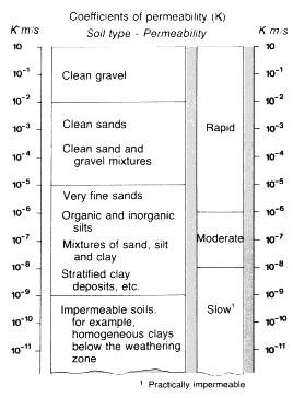
The permeability of a soil is the capacity of the soil to allow water to pass through it. Soil permeability is usually represented by the coefficient of permeability (k), where k is the rate of flow of water per unit area of soil when under a unit hydraulic gradient. In other words, how quickly water flows through a type of soil.
A number of factors affect the permeability of soil. from particle size, impurities in the water, void ratio (the ratio of the volume of voids to the volume of solids), the degree of saturation, and adsorbed water to entrapped air and organic materials. Contrary to popular belief, porosity plays a small part in permeability. While clay soils are the most porous, it is also the least permeable. gravel and sandy soils are the most permeable by far, with gravel being the most permeable.
Soil permeability is determined using several types of tests. These include laboratory experiments such as the Constant Head Permeability Test, the Low-level Permeability test, and the Horizontal Permeability test. Simpler testing methods include the Free Aquifer Test and the Pressurized Aquifer Test.
How to claim this Earthcache.
To claim the find, you will need to perform a modified Free Aquifer Test. Don't worry, it is pretty simple. you will need about an ounce of water.
1. Send a message to the CO and tell him the number of people in your party (geocachers only) and your geo-nicknames. One person can send the answers for a group provided they list the number of people in the group and their geo-nicknames. Then get about an ounce of water from one of the water fountains nearby, the restroom sink or bring your own water bottle.
2. Find a patch of loose soil near the posted coordinates. Describe the loose soil, is it gravely, sandy or clay-like? What is the predominant color? In your estimation, has it rained recently?
3. Pour the water over the patch of soil and count how many seconds it takes for the water to be absorbed into the soil. How long did it take for all the water to disappear into the soil?
4. Using the scale above, how would you classify the permeability of the soil at this location?
5. What type of soil do you believe this to be? Is it St. Johns type or St. Augustine type?
6. Include a picture with your log of yourself or something that identifies you, like your geo-nickname written on a piece of paper, somewhere on or near the GZ. This requirement is NOT optional.
Sources: tensar.co.uk, Wikipedia, USDA NRCS, personal knowledge of the subject matter.