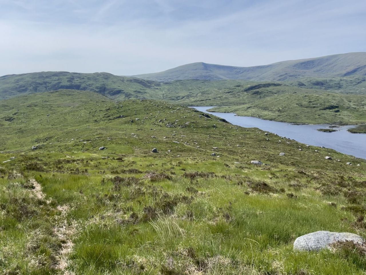
The rig (ridge) running diagonally to the side of Loch Valley.
"Rig n." A ridge of high ground, a long narrow hill, a hill-crest.
"Jarkness n." Unknown. No compelling reference found.
The Galloway hills are a delightful place to spend a day hillwalking. For such a southerly location, these hills are surprisingly remote.
This landscape is full of oddly named places and features. My favourite of all is the "Rig of the Jarkness" but there are lots more, such as the The Clints of the Buss which is close-by. Where did those names come from?
Wikipedia describes the process that Ordnance Survey used to obtain names from locals, laid down by Major Thomas Colby:
"The persons employed on the survey are to endeavour to obtain the correct orthography of the names of places by diligently consulting the best authorities within their reach. The name of each place is to be inserted as it is commonly spelt, in the first column of the name book and the various modes of spelling it used in books, writings &c. are to be inserted in the second column, with the authority placed in the third column opposite to each".
So there was a day long ago when an Ordnance Survey man was sent by his boss to ask locals of place names. I imagine that he'd soon be spotted by a canny old shepherd, most likely in the bar of a local hotel:
"And what's this place called?", asked the enthusiastic young cartographer, pointing at his incomplete map.
"Aye now, laddie..." replied the shepherd. "That y'ken is the... the... "Rig of the Jarkness", making up the name on the fly and smiling at his inventiveness.
"...and I'll have another dram for my trouble, if you don't mind".
After a long evening, both left happy. I have a vivid imagination.
The cache
The cache is a double lock-n-lock container containing a basic logbook and pencil.
There is a very obvious glacial erratic up here - see spoiler for more help.
It goes without saying but PLEASE check that both containers are properly sealed before leaving. This place is sopping wet for 364 days of the year and water finds its way into any gap.
A warning
You've read it all before but I have to repeat it. This is a tough walk in a place where the weather can suddenly turn nasty. If your visibility goes, there is a real danger of blundering off a "clint" leading to injury or worse. Boots, waterproofs, a map and food are essential. Tell someone where you're going and when you get back. You know the drill. Midge repellant is not always needed but when they're about they can be murderous.
Be aware that the path is sometimes of very poor quality and DOES NOT FEATURE AT ALL on OS maps. It IS depicted on OpenStreetMap, so if your device can display that, you may find it a helpful if impefect guide.
A circular route
Obviously this is optional so if you're planning your own route, ignore the following. But if you're contemplating a day in the hills and want to take in a few caches on the way, this guide may be useful. The total distance is a tough 9.5 miles. Some of it is on good forestry track and some on unpathed moorland. But you knew that, right?
At the time of publication, here is a list of caches on the route:
Bruce's Stone (Glentrool)
Loch Trool Circuit no 9 - Buchan Burn Tree
Loch Trool Circuit no 8 - Gairland Burn
Loch Troll Circuit 7a - The Road Bridge
Clashdan Brae Traditional Geocache GC7D14R
Sound Clint..... (Earthcache)
The Beast of Galloway.....
Craiglee. (Letterbox Hybrid)
Oan th' brae.....
The Clints of the Butts
The Rig of the Jarkness
Loch Valley
Bird's Eye View of Loch Trool
Credit to all Cache Owners for placing them in excellent locations.
Circular route - detailed instructions
Leave your car at the Bruce’s Stone car park (Waypoint) by Loch Trool and walk east along the "Southern Upland Way" ignoring all signs to other trails. Pass Glenhead and continue upwards until you arrive at the brow of the hill at N55 04.680 W004 25.849 (Waypoint). By now you will have gained a lot of easy height but the going is harder from now on.
Turn left to leave the road and pass the rather redundant gate to look for the “path” . In truth, there IS a path here but I’ll leave it to you to decide how useful it is. In February is was a muddy swamp and I found open ground easier going. In June it was the opposite: the path dry, crumbly and useable but the open ground full of treacherous ankle-turning holes with rock-hard sides made by now-gone hairy beasts.
Head for the Clashdan Brae cache if you haven't already found it. The path fades out and then suddenly reappears to one side or the other. Don't feel despondent; this is the hardest stretch but it improves dramatically from Sound Clint. Work your way along using higher ground where you can avoid obvious boggy places.
Once collecting the caches at Sound Clint, the going gets immediately better. Not only are there fewer hoof holes but lots of extended granite slabs to stride up, all the way to the Craiglee trig point and the two caches there. This is a good place to stop for lunch or to admire the view.
From the trig point, make your way along a narrow but useful goat path down to the small lochans, passing the larger Dow Loch on your right. From there, follow your GPSr to the cache location "Clints of the Buss" and then, if you like, "Rig of the Jarkness".
Carry on to the west end of the “Jarkness” where the path seems to fade out at the sudden drop down to the Gairland Burn. If visibility allows it, look for the burn and the path which IS marked on 1:25k OS maps.
With care, it's a fairly easy scramble down to the level of the burn. At the bottom, its tempting to turn left towards Loch Trool to converge with the burn and path. That way offers only very tough tussocky walking. Instead, turn right and walk the short distance to the Loch Valley outflow (Waypoint). You'll have to find a way to cross the burn but it shouldn't be a challenge.
From the burn, find the squelchy Gairland path (and the cache nearby) before turning around and heading down the path to the road. The carpark is just a short distance away.