BLACKMAN'S BAY BLOWHOLE
Blackmans Bay Blowhole is the name given to a geological formation that has been formed, and continues to be enlarged, by wave action preferentially eroding along a major set of subvertical joints trending in a west southwest direction in the Permian-age sedimentary rocks. There are many other examples of similar erosion along adjacent coasts.
We are currently in an interglacial period, and have been for the past 10,000 years or so, when sea level has been roughly the same as at present. It is possible that the blowhole developed during this period, but it is also possible it is much older: There was a period of over a hundred thousand years during the Last Glacial spanning about 6000 – 120,000 years ago when sea level was 30 – 130m lower than at present, and blowhole formation was not possible. But at around 120,000 – 130,000 years ago, sea level is thought to be up to 10m or so higher than current levels, and blowhole formation might have been active then as well.
FROM SEA CAVE TO BLOWHOLE TO ARCH
The large hole in the earth visible from GZ has resulted from a collapse in the rock following several thousand years of wave action. This type of rock (Permian mudstone) formed around 265 million years ago, and is layered with strong vertical joints or fissures, making it prone to fracturing into large blocks. (This same rock type is found along much of Alum Cliffs.)
Over several thousand years, constant wave action eroded along a weak joint, creating a sea cave. Water and compressed air from wave action then forced its way up a weak, vertical fissure in the rock, spewing out as a blowhole.
Over time, the blowhole widened, until the entire fracture zone collapsed resulting in the sea arch you see today.
The arch will continue to change over time as fractures develop and weathering continues. Expect to see ongoing minor collapses in the roof and walls.
FORMATION OF SEA CAVE AND BLOWHOLE
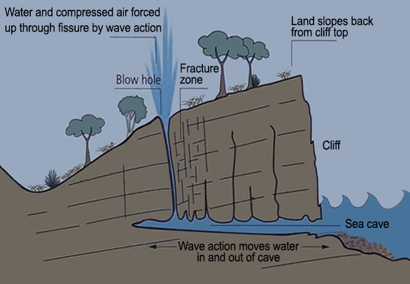
Step 1 - Formation of sea cave and blowhole
FORMATION OF ARCH
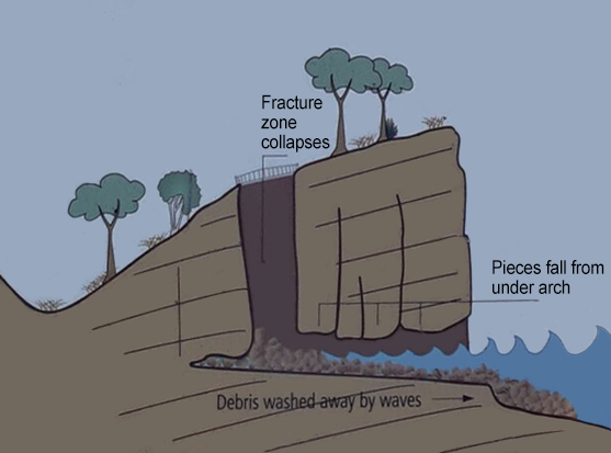
Step 2 - Formation of arch (present landform)
LOGGING REQUIREMENTS
In order to log this EarthCache, you must visit the location and answer the following questions:
- At the listed coordinates, stand and face the arch. Describe the surrounding rock. Note the colour, any faults or fractures, and whether any strata (layers of sedimentary rock) are visible?
- Describe the shape of the arch. E.g. is it circular or square, with a rounded roof or square roof? Why do you think erosion has occurred in this manner to form this shape?
- Upload a photo with your log of you and/or your GPS at GZ. Be careful not to include spoilers to the above questions!
Please then email, or send a message (through geocaching.com), your answers to the above questions. Feel free to log your find in anticipation - we'll let you know if there are any issues. Logs without the emailed answers may be deleted.