
Bienvenido a Playa San Luis en Guanacaste, Costa Rica. Además de una hermosa arena, magníficas puestas de sol y hermosas aguas, alberga no uno, sino dos espiráculos activos y productivos justo en la playa. Quizás tres, si las condiciones son las correctas. En este Earthcache aprenderás más sobre los espiráculos y, con suerte, podrás informar sobre las buenas condiciones de ese día. Verás más actividad durante la marea alta, puedes consultar esta web para conocer las mareas de la zona.
Advertencia: por su propia seguridad, ¡no se acerque demasiado a los espiráculos activos!
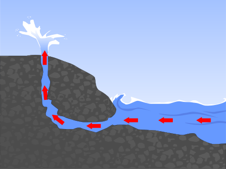
Un bufadero o bufón es una formación geológica de morfología litoral en acantilados de origen cárstico o volcánico. Se trata, básicamente, de una chimenea natural abierta normalmente en un acantilado, que está comunicado con simas marinas. Cuando la mar está en pleamar, el agua choca con fuerza contra los acantilados y sube a través de estas chimeneas, saliendo despedida hacia arriba por el hueco a modo de géiser y produciendo un sonido característico. Monkhouse lo define como Hendidura subvertical que enlaza una cueva marina con la superficie del borde de un acantilado; en ocasiones, la fuerza de compresión de las olas que irrumpen en el interior de la gruta expulsa por la hendidura o chimenea espuma pulverizada del agua del mar.
Instrucciones de registro: envíame respuestas a las siguientes preguntas. Excepto donde se especifique, no publique sus respuestas, solo las observaciones solicitadas.
- Localice el área del espiráculo. Describa cualquier actividad de los espiráculos, si la observa: número de espiráculos activos, altura del rocío, ángulo, sonidos, etc.
- Describe la superficie del suelo alrededor del(los) espiráculo(s).
- ¿Cuál es el tamaño aproximado de la abertura del espiráculo más grande?
- Describe con tus propias palabras cualquier relación que pueda existir entre la formación del espiráculo y el suelo alrededor del espiráculo. Utilice wikipedia para obtener más información si es necesario.
- Publique la siguiente observación en su registro: altura aproximada del agua de mar con respecto a la parte superior de la superficie del suelo (es decir, estimación de mareas); y altura aproximada de cualquier erupción.
- (Opcional) publique una foto suya o de su GPSr en las inmediaciones.

Welcome to Playa San Luis in Guanacaste, Costa Rica. Besides beautiful sand, great sunsets, and lovely water, it is home to not one, but two active and productive blowholes right on the beach. Perhaps three, if conditions are correct. In this Earthcache you'll learn more about blowholes, and hopefully you can report on good conditions on the day. You'll see more activity during high tide, you can consult this website for tides in the area.
Warning: for your own safety, do not get too close to the active blowholes!
In geology, a blowhole or marine geyser is formed as sea caves grow landward and upward into vertical shafts and expose themselves toward the surface, which can result in hydraulic compression of seawater that is released through a port from the top of the blowhole. The geometry of the cave and blowhole along with tide levels and swell conditions determine the height of the spray.
Logging instructions: send me answers to the following questions. Except for where specified, do not post your answers, just the requested observations.
- Locate the blowhole area. Describe any blowhole activity if seen: number of active blowholes, height of spray, angle, sounds, etc.
- Describe the surface of the ground around the blowhole(s).
- What is the approximate size of the opening of the larger blowhole?
- Describe in your own words any relationship that might exist between the formation of the blowhole(s) and the ground around the blowhole. Use wikipedia for more insight if needed.
- Post the following observation on your log: approximate height of seawater with respect to the top of the ground surface (ie. estimate of tides); and approximate height of any eruptions.
- (Optional) post a photo of yourself or your GPSr at the vicinity.
felicidades a The Sharkies por los primeros en encontrar!!
Congratulations to The Sharkies for the FTF!!