🧭 Përmet, Langarica canyon. 🧭
With this earthcache, I invite you to discover a marvelous natural site. But also to observe a kilometric order anticline.
🇦🇱 shqiptare 🇦🇱
Për të vizituar kanionin, do të keni dy zgjedhje:
Zgjedhja e parë është të ngjiteni në lumë dhe të zbrisni përsëri. Kanioni është afërsisht 4.5 km i gjatë dhe duhen 3 ose 4 orë për të ecur në total. Ky opsion përfshin rreziqe dhe mund të praktikohet vetëm në muajt e verës. Sigurisht, edhe në verë, duhet të prisni që të lageni dhe ndoshta të notoni. Është shumë e lehtë kanionimi, por gjithsesi kanioni! Kini kujdes, toka mund të jetë e rrëshqitshme.
Opsioni i dytë është të eksploroni kanionin nëpërmjet shtigjeve që e shohin atë. Nuk pata mundësi ta bëj këtë shëtitje, por në internet ka topoguide. Për të ecur mbi 13 km duhen 4,5 orë.
Fillimi i turit është tek ura osmane e Katiut. Lini pak kohë në kthim për të shijuar pishinat e ushqyer nga burimet termale.
🧭 Kanioni! 🧭
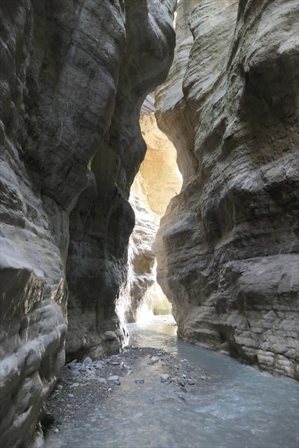
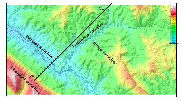
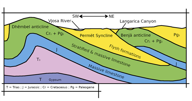
I vendosur jo shumë larg Përmetit, kanioni i Langaricës është një cep i vogël i parajsës. Është afërsisht 4.5 km i gjatë dhe midis 30 dhe 150 metra i lartë. Langarica është një nga lumenjtë e fundit të egër në Evropë. Ky lumë ka gërmuar kanionin përgjatë një çarje karstike dhe përshkon antiklinalin e Benjës të përbërë nga gurë gëlqerorë nga Kretaku i Sipërm deri në Eocen.
|
🧭 Antiklinal dhe sinklinal ! 🧭
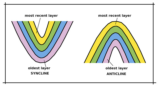
Toka përbëhet nga shtresa të ndryshme, të përbërë nga shkëmbinj ose sedimente. Këto shtresa “vendosen” njëra mbi tjetrën, duke ndjekur një renditje kronologjike. Më e vjetra është, në rendin normal të gjërave, poshtë, dhe çdo shtresë më e re është mbivendosur mbi të. Me kalimin e kohës, dhe ndërsa pllakat tektonike lëvizin, shtresat do të deformohen. Kur dy pllaka përplasen, shtresat do të rrudhen. Palosjet mund të kenë shkallë të ndryshme, nga disa centimetra në disa kilometra. Në palosjet më të mëdha dallohen kryesisht dy lloje palosjesh, palosja sinklinale dhe palosja antiklinale. Për të vizualizuar mirë, duhet të imagjinoni valët: majën e valës, ose luginën e valës.
Ne flasim për një rregullim antiklinal nëse shtresat janë në "majë të valës". Në këtë konfigurim, shtresa më e re është jashtë palosjes dhe shtresa më e vjetër është brenda palosjes.
Nëse shtresat shfaqen në një "lug vale", atëherë flasim për një rregullim sinklinal. Në këtë rast, shtresa më e re është brenda palosjes dhe shtresa më e vjetër është jashtë palosjes. Në hartat gjeologjike, është e zakonshme të shihet një sërë palosjesh antiklinale dhe sinklinale.
|
🧭 zhytje. 🧭
 Përkufizim :
Dip është një term në gjeologji dhe gjeomorfologji që përcakton prirjen e shtresave sedimentare, për ta dalluar atë nga pjerrësia topografike. Një tregues zhytjeje kombinon treguesit e drejtimit dhe pjerrësisë së planit të përshkruar, ndërsa termi zhytje e thjeshtë i referohet vetëm këndit të prirjes. Për të kryer matjet në terren, gjeologët përdorin një busull me një klinometër.
|
 Vija e pjerrësisë më të madhe :
Vija e pjerrësisë më të madhe është Vija e relievit e cila, duke u nisur nga një pikë e caktuar, merr gjithmonë pjerrësinë maksimale. Përcaktimi i kësaj linje është hapi i parë në matjen e rënies. Një mënyrë e thjeshtë për të përcaktuar vijën e pjerrësisë më të madhe është të derdhni ujë në aeroplan. Rrjedhja e ujit të marrë do të korrespondojë me këtë linjë. Drejtimi i zhytjes korrespondon me drejtimin e vijës së pjerrësisë më të madhe të drejtuar nga poshtë. Vlerat janë midis 0° dhe 360° ku 360° tregon veriun dhe merret me një busull.
|
 Drejtimi i sipërfaqes së sheshtë :
Drejtimi i shtresës, korrespondon me azimutin e vijës horizontale pingul me vijën e pjerrësisë më të madhe të rrafshit. Drejtimi matet në lidhje me veriun e vërtetë në drejtim të akrepave të orës në rrafshin horizontal. Vlerat janë midis 0° dhe 360° ku 360° tregon Veriun. Rregulli i dorës së djathtë është një mënyrë e thjeshtë për të gjetur orientimin e një strukture planare dhe mund të përfaqësohet si më poshtë:
- Shuplaka e dorës së djathtë vendoset në rrafshin që do të matet
- Katër gishtat tregojnë poshtë shpatit
- Gishti i madh i hapur tregon drejtimin e sipërfaqes së sheshtë.
|
zhytje :
Zhytja është këndi midis një sipërfaqeje të shtresës dhe një rrafshi horizontal. Matja e saj është ajo e zhytjes së vijës së pjerrësisë më të madhe të kësaj sipërfaqeje. Pastaj ju vetëm duhet të matni këndin e formuar nga pjerrësia dhe rrafshi horizontal. Në terren, një gjeolog përdor një klinometër. Këndi i uljes është gjithmonë ndërmjet 0° dhe 90°.
- Ulja është zero nëse rrafshi e matur është horizontale. Në këtë rast nuk ka drejtim, ose më saktë, plani është në të gjitha drejtimet.
- Ulja është e lehtë nëse rrafshi e matur është pothuajse horizontale (më pak se 30 gradë).
- Ulja është normale nëse rrafshi e matur është ndërmjet 30° dhe 60°.
- Ulja është e pjerrët nëse rrafshi e matur është pothuajse vertikale (më shumë se 60 gradë).
- Zhytja thuhet se është vertikale nëse rrafshi i matur është vertikal. Në këtë rast, nuk ka drejtim për një vijë të drejtë, por ka një (ose më mirë dy) drejtim për një sipërfaqe të rrafshët.
|
|
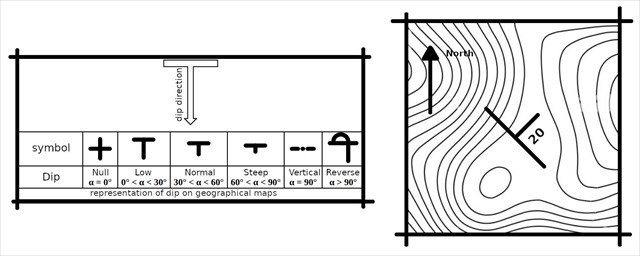
Përfaqësimi në hartat gjeografike :
Në hartat gjeologjike, zhytja e shtresave tregohet nga një lloj shigjete në formë T, maja e së cilës drejtohet në drejtimin e zhytjes.
|
|
🧭 Kërkesat e regjistrimit: 🧭
Nuk ka asnjë kontejner për të gjetur ose një ditar për të nënshkruar. Pasi të keni qenë në vend për të kërkuar përgjigjet e pyetjeve, regjistroni këtë memorie "Found it" dhe më dërgoni përgjigjet tuaja të sugjeruara, duke specifikuar kodin GC të memories, qoftë nëpërmjet profilit tim ose nëpërmjet mesazheve të geocaching.com (Qendra e mesazheve ), dhe unë do t'ju kontaktoj nëse ka ndonjë problem.
🧭 Pyetje : 🧭
E rëndësishme :
Për të eksploruar kanionin në këmbë, nëse aventura ia vlen udhëtimi, mos e vendosni jetën në rrezik, sepse çdo vit autoritetet dënojnë aksidente, ndonjëherë fatale. Në varësi të periudhës, mund të ketë reshje të papritura në lartësi duke bërë që niveli i lumit të rritet papritur. Mësoni më shumë nga vendasit. Ju gjithmonë mund të ecni në majë të shkëmbinjve dhe prej andej të nxirrni përgjigjet e pyetjeve.
Do t'ju duhet një busull. nga ana tjeter per klinometrin nese e ke aq me mire por nuk eshte e detyrueshme. I kam marrë matjet me hamendje dhe nuk pres saktësi në shkallën më të afërt nga ju.
-
Te Ura Osmane, përshkruani (përafërsisht) drejtimin e goditjes, zhytjen dhe drejtimin e zhytjes së shtresave gëlqerore.
-
Tek ujëvarat, përshkruani (përafërsisht) drejtimin e goditjes, zhytjen dhe drejtimin e zhytjes së shtresave gëlqerore.
-
Në digë, përshkruani (përafërsisht) drejtimin e goditjes, zhytjen dhe drejtimin e zhytjes së shtresave gëlqerore.
-
Me vëzhgimet tuaja, vizatoni një diagram të kanionit dhe përcaktoni nëse kanioni kalon një antiklinal apo një sinklinal. Bashkangjisni diagramin.
-
(opsionale) Nëse zbrisni nga lumi në kanion, do të keni një përshtypje të çuditshme, çfarë është ajo? Pse ?
-
(opsionale) Një foto e juaja ose një objekt që ju përket në këtë faqe idilike do të vlerësohet shumë.
🇬🇧 English 🇬🇧
To visit the canyon, you will have two choices :
The first choice is to go up the river then go back down. The canyon is approximately 4.5 km long and takes 3 or 4 hours to walk in total. This option involves risks and can only be practiced in the summer months. Of course, even in the summer, you should expect to get wet and perhaps swim. It’s very easy canyoning, but canyoning nonetheless! Be careful, the ground can be slippery.
The second option is to explore the canyon via the paths that overlook it. I didn't have the opportunity to do this hike, but there are topoguides on the internet. It takes 4.5 hours to walk over 13 km.
The start of the tour is at the Ottoman bridge of Katiut. Allow some time on your return to enjoy the pools fed by the thermal springs.
🧭 The canyon ! 🧭
Located not far from Përmet, the Langarica canyon is a little corner of paradise. It is approximately 4.5 km long and between 30 and 150 meters high. Langarica is one of the last wild rivers in Europe. This river has dug the canyon along a karst fault and crosses the Benja anticline made up of limestones from the Upper Cretaceous to the Eocene.
|
🧭 Anticline and Syncline ! 🧭
The ground is made up of different layers, made up of rocks or sediments. These layers are “placed” on top of each other, following a chronological order. The oldest is, in the normal order of things, below, and each newer layer is superimposed on it. Over time, and as the tectonic plates move, the layers will deform. When two plates collide, the layers will wrinkle. Folds can have different scales, from a few centimeters to several kilometers. In the larger scale folds, two types of folds are mainly distinguished, the syncline fold and the anticlinal fold. To visualize well, you have to imagine waves: the top of the wave, or the trough of the wave.
We speak of an anticlinal arrangement if the strata are at the “top of the wave”. In this configuration, the newer layer is outside the fold and the older layer is inside the fold.
If the strata appear in a “wave trough”, we then speak of a synclinal arrangement. In this case, the newer layer is inside the fold and the older layer is outside the fold. On geological maps, it is common to see a succession of anticlinal and synclinal folds.
|
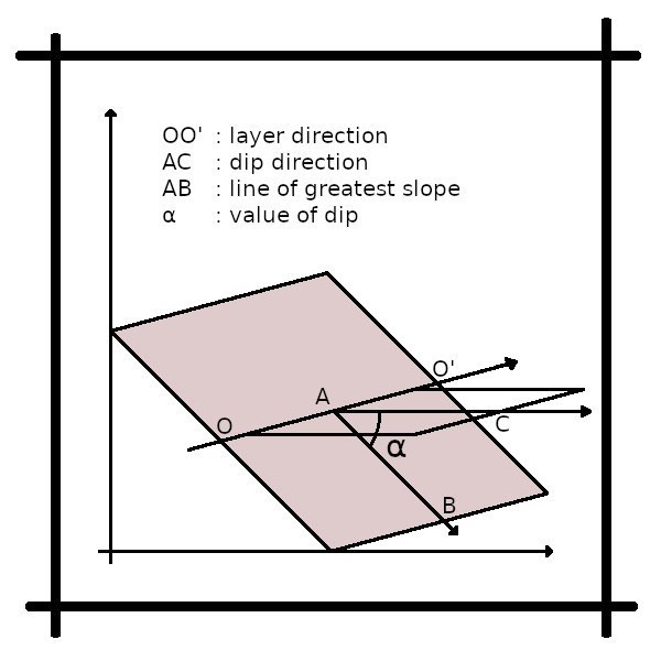
🧭 The dip. 🧭
Definition :
Dip is a term in geology and geomorphology which designates the inclination of sedimentary layers, to differentiate it from topographic slope. A dip indication combines indications of direction and inclination of the plane described, while the term simple dip refers to the angle of inclination only. To carry out measurements in the field, geologists use a compass with a clinometer.
|
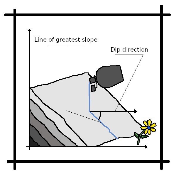
The line of greatest slope :
The line of greatest slope is the Line of a relief which, starting from a given point, always takes the maximum slope. Defining this line is the first step in measuring dip. A simple way to determine the line of greatest slope is to pour water on the plane. The trickle of water obtained will correspond to this line. The direction of dip corresponds to the direction of the line of greatest slope pointing downward. The values are between 0° and 360° where 360° indicates North and is obtained with a compass.
|
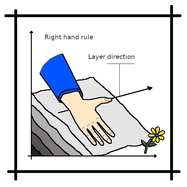
The layer direction (strike) :
The layer direction or strike, corresponds to the azimuth of the horizontal line perpendicular to the line of greatest slope of the plane. Direction is measured relative to true north clockwise on the horizontal plane. Values are between 0° and 360° where 360° indicates North. The right hand rule is a simple way to find the orientation of a planar structure and can be represented as follows:
- The palm of the right hand is placed on the plane to be measured
- The four fingers point down the slope
- The open thumb indicates the direction of the plane
|
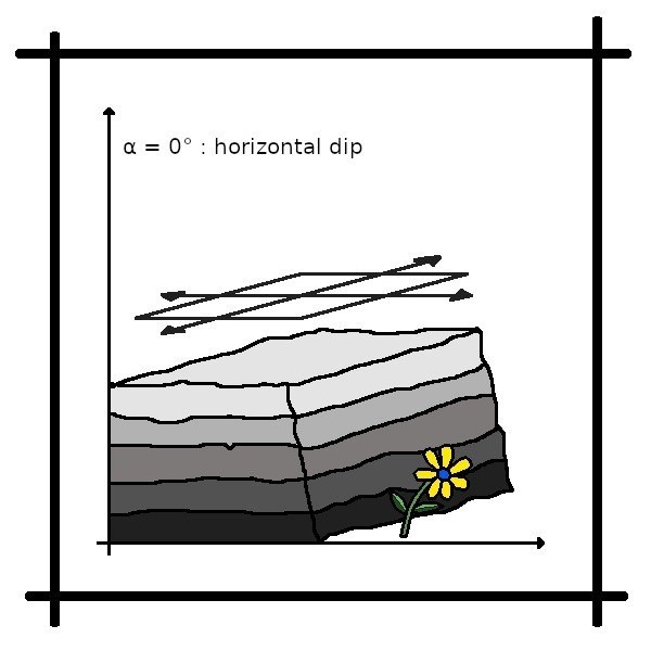
Dip :
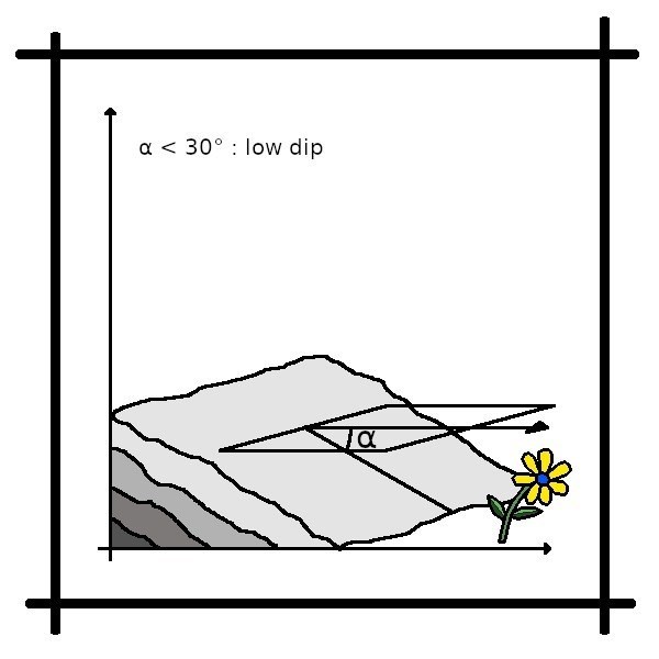
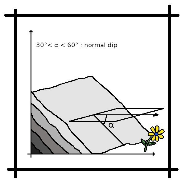
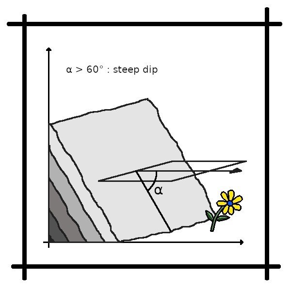
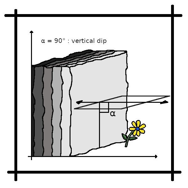
Dip is the angle between a surface of the stratum and a horizontal plane. Its measurement is that of the plunge of the line of greatest slope of this surface. Then you just have to measure the angle formed by the slope and the horizontal plane. In the field, a geologist uses a clinometer. The dip angle is always between 0° and 90°.
- The dip is zero if the plane measured is horizontal. In this case there is no direction, or rather, the plan is in all directions.
- The dip is slight if the measured plane is almost horizontal (less than 30 degrees).
- The dip is normal if the measured plane is between 30° and 60°.
- The dip is steep if the measured plane is almost vertical (more than 60 degrees).
- The dip is said to be vertical if the plane measured is vertical. In this case, there is no direction for a line, but there is one (or rather two) direction for a plane.
|
|
|
Representation on geographical maps :
On geological maps, the dip of the layers is indicated by a sort of T-shaped arrow whose tip points in the direction of the dip.
|
|
|
🧭 Logging Requirements : 🧭
There is no container to find or a logbook to sign. After having been on the spot to look for the answers to the questions, log this "Found it" cache and send me your suggested answers, specifying the GC code of the cache, either via my profile or via geocaching.com messaging (Message Center), and I will contact you if there is any problem.
🧭 Questions : 🧭
Important :
To explore the canyon on foot, if the adventure is worth the trip, do not put your life in danger because every year, the authorities deplore accidents, sometimes fatal. Depending on the period, there may be sudden showers in the heights causing the river level to suddenly increase. Find out more from the locals. You can always hike to the top of the cliffs and from there deduce the answers to the questions.
You will need a compass. on the other hand for the clinometer, if you have one, so much the better, but it is not obligatory. I took my measurements by guesswork and I do not expect precision to the nearest degree from you.
-
At the Ottoman Bridge, describe (approximately) the strike direction, the dip, and the dip direction of the limestone strata.
-
At the waterfalls, describe (approximately) the strike direction, the dip, and the dip direction of the limestone strata.
-
At the dam, describe (approximately) the strike direction, the dip, and the dip direction of the limestone strata.
-
With your observations, draw a diagram of the canyon and determine whether the canyon crosses an anticline or a syncline. Attach the diagram.
-
(optional) If you go down the river into the canyon you will have a strange impression, what is it ? Why ?
-
(optional) A photo of you or an object belonging to you on this idyllic site will be very appreciated.
🇫🇷 Français 🇫🇷
Pour visiter le canyon, vous aurez deux choix :
Le premier choix est de remonter la rivière puis de la redescendre. Le canyon fait environ 4,5 km de long et prend 3 ou 4 heures de marche au total. Cette option comporte des risques et ne peut être pratiquée que pendant les mois d'été. Bien sûr, même en été, vous devez vous attendre à vous mouiller et peut-être à nager. C’est du canyoning très facile, mais du canyoning quand même ! Attention, le sol peut être glissant.
La deuxième option consiste à explorer le canyon via les sentiers qui le surplombent. Je n'ai pas eu l'occasion de faire cette randonnée, mais il existe des topoguides sur internet. Il faut 4h30 pour parcourir les 13 km à pied que comporte la randonnée.
Le début de la visite se fait au pont ottoman de Katiut. Prévoyez du temps à votre retour pour profiter des bassins alimentés par les sources thermales.
🧭 Le canyon ! 🧭
Situé non loin de Përmet, le canyon de Langarica est un petit coin de paradis. Il mesure environ 4,5 km de long et entre 30 et 150 mètres de haut. Langarica est l'une des dernières rivières sauvages d'Europe. Cette rivière a creusé le canyon le long d'une faille karstique et traverse l'anticlinal de Benja constitué de calcaires du Crétacé supérieur à l'Éocène.
|
🧭 Anticlinal et Synclinal ! 🧭
Le sol est formé de différentes couches, constituées de roches ou de sédiments. Ces couches sont « placées » les unes sur les autres, selon un ordre chronologique. La plus ancienne se trouve, dans l'ordre normal des choses, en dessous, et chaque couche plus récente se superpose à elle. Au fil du temps et à mesure que les plaques tectoniques se déplacent, les couches se déforment. Lorsque deux plaques entrent en collision, les couches se froissent. Les plis peuvent avoir différentes échelles, de quelques centimètres à plusieurs kilomètres. Dans les plis à plus grande échelle, on distingue principalement deux types de plis, le pli synclinal et le pli anticlinal. Pour bien visualiser, il faut imaginer des vagues : le sommet de la vague, ou le creux de la vague.
On parle d'arrangement anticlinal si les strates sont au « sommet de la vague ». Dans cette configuration, la couche la plus récente se trouve à l’extérieur du pli et la couche la plus ancienne à l’intérieur du pli.
Si les strates apparaissent dans un « creux de vague », on parle alors d'arrangement synclinal. Dans ce cas, la couche la plus récente se trouve à l’intérieur du pli et la couche la plus ancienne à l’extérieur du pli.
Sur les cartes géologiques, il est courant de voir une succession de plis anticliaux et synclinaux.
|
🧭 Le pendage. 🧭
Definition :
Le pendage est un terme en géologie et géomorphologie qui désigne l'inclinaison des couches sédimentaires, pour la différencier de la pente topographique. Une indication de pendage combine des indications de direction et d'inclinaison du plan décrit, tandis que le terme pendage simple désigne uniquement l'angle d'inclinaison. Pour effectuer des mesures sur le terrain, les géologues utilisent une boussole avec un clinomètre.
|
La ligne de plus grande pente :
La ligne de plus grande pente est la Ligne d'un relief qui, à partir d'un point donné, prend toujours la pente maximale. Définir cette ligne est la première étape de la mesure du pendage. Un moyen simple de déterminer la ligne de plus grande pente consiste à verser de l’eau sur le plan. Le filet d'eau obtenu correspondra à cette ligne. La direction du pendage correspond à la direction de la ligne de plus grande pente dirigée vers le bas. Les valeurs sont comprises entre 0° et 360° où 360° indique le Nord et s'obtient avec une boussole.
|
La direction du plan (strike) :
La direction de la couche correspond à l'azimut de la ligne horizontale perpendiculaire à la ligne de plus grande pente du plan. La direction est mesurée par rapport au nord géographique dans le sens horaire sur le plan horizontal. Les valeurs sont comprises entre 0° et 360° où 360° indique le Nord. La règle de la main droite est un moyen simple de trouver l'orientation d'une structure planaire et peut être représentée comme suit :
- La paume de la main droite est posée sur le plan à mesurer
- Les quatre doigts pointent vers le bas de la pente
- Le pouce ouvert indique la direction de l'avion
|
Pendage :
Le pendage est l'angle entre une surface de la strate et un plan horizontal. Sa mesure est celle du plongement de la ligne de plus grande pente de cette surface. Il suffit ensuite de mesurer l'angle formé par la pente et le plan horizontal. Sur le terrain, un géologue utilise un clinomètre. L'angle d'inclinaison est toujours compris entre 0° et 90°.
- Le pendage est nul si le plan mesuré est horizontal. Dans ce cas, il n'y a pas de direction, ou plutôt, le plan est dans toutes les directions.
- Le pendage est faible si le plan mesuré est presque horizontal (inférieur à 30 degrés).
- Le pendage est normal si le plan mesuré est compris entre 30° et 60°.
- Le pendage est fort si le plan mesuré est presque vertical (plus de 60 degrés).
- Le pendage est dit vertical si le plan mesuré est vertical. Dans ce cas, il n’y a pas de direction pour une droite, mais il y a une (ou plutôt deux) direction pour un plan.
|
|
|
Représentation sur cartes géologiques :
Sur les cartes géologiques, le pendage des couches est indiqué par une sorte de flèche en forme de T dont la pointe est dirigée dans le sens du pendage.
|
|
|
🧭 Rappel concernant les Earthcaches : 🧭
Il n'y a pas de conteneur à rechercher ni de logbook à signer. Après avoir été sur les lieux pour chercher les réponses aux questions, loguez cette cache "Found it" et envoyez-moi vos propositions de réponses, en précisant le code GC de la cache, soit via mon profil, soit via la messagerie geocaching.com (Message Center), et je vous contacterai en cas de problème.
🧭 Questions : 🧭
Important :
Pour explorer le canyon à pied, si l'aventure vaut le déplacement, ne mettez pas votre vie en danger car chaque année, les autorités déplorent des accidents, parfois mortels. Selon les périodes, il peut y avoir des averses soudaines dans les hauteurs provoquant une montée brutale du niveau de la rivière. Renseignez-vous davantage auprès des locaux. Le cas échéant, vous pouvez toujours faire une randonnée au sommet des falaises et en déduire les réponses aux questions.
Vous aurez besoin d'une boussole. Par contre pour le clinomètre, si vous en avez un, tant mieux, mais ce n'est pas obligatoire. J'ai pris mes mesures au jugé et je n'attends pas de votre part une précision au degré près.
-
Au pont Ottoman, décrivez (approximativement) la direction du plan, le pendage et la direction du pendage des strates calcaires.
-
Aux cascades, décrivez (approximativement) la direction du plan, le pendage et la direction du pendage des strates calcaires.
-
Au barrage, décrivez (approximativement) la direction du plan, le pendage et la direction du pendage des strates calcaires.
-
Avec vos observations, dessinez un schéma du canyon et déterminez si le canyon traverse un anticlinal ou un synclinal. Joindre le schéma à votre réponse.
-
(facultatif) Si vous descendez la rivière dans le canyon vous aurez une impression étrange, qu'est-ce que c'est ? Pourquoi ?
-
(facultatif) Une photo de vous ou d'un objet vous appartenant sur ce site idyllique sera très appréciée.
🧭 Map 🧭