Welcome to Malhamdale in the Yorkshire Dales National Park!

This virtual cache will take you to four locations: Janet's Foss, Gordale Scar, Malham Cove and Malham Cove Fields. It will ask you to answer three questions and take one photograph in order to log a find.
Suggested Route
It's recommended that the four locations are visited by walking anti-clockwise along the circular Malham Landscape Trail which starts and ends in Malham Village. Starting at the National Park Centre (the primary parking waypoint for this cache), the suggested route is:
- Follow the blue route to Janet’s Foss
- Then the red route until Gordale Scar
- Then the purple route to Malham Cove
- Then the gold route to return to the National Park Centre.
The suggested route is 7.2km (4.5 miles) long. When I visited, it took me 3h30 to complete; I was not rushing, I paused liberally at the highlights, and I stopped for lunch halfway round. There is approximately 150m of ascent gain over the total route. A map of the route can be found on the Yorkshire Dales National Park website here.
Accessibility
The terrain underfoot is mainly crushed stone/gravel, flagstone, tarmac or grassy slopes. There are three main places where the terrain is more difficult. The first is around Janet's Foss waterfall where the path uses the limestone bedrock which requires a short scramble and can be slippery. The second is in the immediate vicinity of Gordale Scar where the closer you get to the waterfall the rougher the path gets, but you will be able to meet the requirements for this cache without needing to get too close. The third is across the top of Malham Cove where the limestone pavement creates an uneven walking surface and where the rock may be loose, followed by a long series of unevenly spaced steps down to the bottom of the cliffs.
It is possible to avoid some of the rougher terrain if arriving by car by completing this cache in two sections: first by using the gold route to access Malham Cove from Malham Village and returning the same way, and then by parking at Gordale Bridge (the secondary parking waypoint for this cache) to access Janet's Foss and Gordale Scar.
If accessibility is important to you, I'm keen to listen to suggestions to improve the accessibility of this virtual cache.
Janet's Foss
 The first stop on the walk after leaving Malham and following the blue route is Janet's Foss. This is a small waterfall carrying the Gordale Beck over limestone, with a plunge pool at the base.
Historically the pool was used as a sheep dip to help protect livestock against parasites; now the waterfall is a popular spot for wild swimming all year round, but this is particularly pleasant on a summer's evening.
Gordale Scar
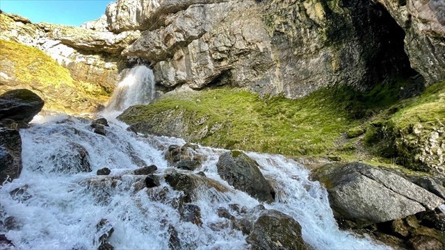 The next stop by continuing from Janet's Foss and picking up the red route is Gordale Scar. This is a tremendous waterfall which cascades down from the top of the limestone into a steep gorge created by glaciation in previous ice ages.
In periods of low rainfall you'll often see hardy individuals climbing up the waterfall to access the upper slopes of the scar. On a warm day, the shaded gorge is often a few degrees cooler than the surrounding countryside.
Malham Cove
 The next stop by returning from Gordale Scar along the red route and picking up the purple route is Malham Cove. At the top, you'll find hectares of limestone pavement formed by glaciers and erosion from the rain over thousands of years, and if you're brave you'll peer over the edge of the cliff down to the pasture below. Long ago this was a massive waterfall, but only once in modern times has it been known that the water flows over the top, instead the stream flows underground and emerges at the base.
After descending the long series of rough steps you'll arrive at the base of the cliffs where you'll often find rock climbers scaling the face, or if you're lucky see the pair of nesting peregrine falcons here.
The fields here at the base and along the gold route back to Malham Village have been farmed for generations, and you may see fluffy cows at times.
Logging your Find
In order to log your find, please provide answers to the below questions and take the one photo as directed. Send the answers to me, and add the photo to your log.
- Go to Janet's Foss (N54 03.947 W002 08.174, virtual stage 01).
- There is an information board along the footpath entitled "Janet's Foss". According to the board, who was Janet?
- Go to Gordale Scar (N54 04.360 W002 07.833, virtual stage 02).
- Take a photo of yourself or an item that identifies you with Gordale Scar (the waterfall) in the background.
- Go to Malham Cove (N54 04.362 W002 09.475, virtual stage 03).
- Estimate the height of Malham Cove (the cliff) from the base where the water emerges to the top.
- Go to Malham Cove Fields (N54 03.950 W002 09.460, virtual stage 04).
- There is an information board entitled "Malham's Ancient Fields". According to the board, when was Malham village probably founded?
Cache listed with the kind permission of the National Trust and Kirkby Malham Parish Council.

Virtual Rewards 4.0 - 2024-2025
This Virtual Cache is part of a limited release of Virtuals created between January 17, 2024 and January 17, 2025. Only 4,000 cache owners were given the opportunity to hide a Virtual Cache. Learn more about Virtual Rewards 4.0 on the Geocaching Blog.