Part of a series of multi's designed to help you explore some Christchurch suburbs. I'm working from the suburb boundaries in Google Maps, which I've come across in a number of other places.
Riccarton
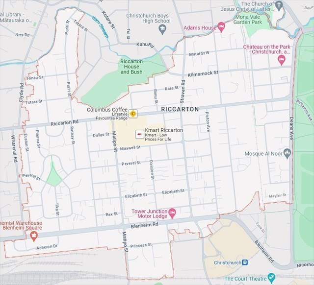
Map Data ©2023 (image from Google Maps)
Neighbouring suburbs: Ilam,
Fendalton,
Christchurch Central, Addington, Middleton, Upper Riccarton.
Name origin: The Deans farm was renamed from Putaringamotu to Riccarton on Christmas Day 1848. Riccarton was the name of the parish in Scotland that the Deans family came from.
Two of the main roads through the suburb (Riccarton Road and Blenheim Road) were established soon after the first British colonists arrived in 1850. Riccarton Road was opened on June 21, 1851. At first it was known as Harewood Road as it was created to provide a route to Harewood Forest near Oxford. A channel was dug beside Riccarton Rd to provide a way to transport logs milled in Deans Bush to Market Place (which was renamed Victoria Square in 1900 as part of the Christchurch 50th jubilee celebrations). In the early years Deans Bush extended all the way to Riccarton Road. In winter the shade from Deans Bush made that stretch of road icy, and sacking was sometimes put over horses' hooves to stop them from slipping. The Addington Saleyards opened in November 1874. While some stock arrived by rail (the sale yards were built next to the Main North Line) a lot of stock was driven to the saleyards along a stock route that became Blenheim Road.
Although Riccarton is not far from central Christchurch, the Riccarton area was slow to develop. Hagley Park was a barrier, and the land was swampy. In 1913 Riccarton Borough was created by a group keen to see the area develop (I think prior to that the land was part of the Waimairi County Council). The boundaries of Riccaron Borough are very similar to the boundaries of the modern suburb. Riccarton Borough extended a bit further to the South East, with the initial part of Lincoln Road forming part of the boundary. The northern boundary is the same for Riccarton Borough and the suburb. For the most part the boundary follows a stream. However, the boundary leaves the stream and loops south so that Riccarton House and bush lie outside Riccarton, and apparently this was something the Deans family asked for when Riccarton Borough was created.
An early goal of Riccarton Borough was to have the saleyards moved (having stock driven down Blenheim Road wasn't popular with businesses or residents). The saleyards stayed put, and in fact out-lasted Riccarton Borough, which became part of Christchurch City in the big local body reorganisation of 1989 (the saleyards relocated to Canterbury Agricultural Park in Wigram in 1997).
A number of waypoints are at the locations of early homesteads. WP1 is a plaque in Shands Reserve. John Shand arrived in 1851 and took up a 100-acre land parcel bounded by Riccarton Rd, Wharenui Rd, Blenheim Rd and Matipo Streets (which is most of the western part of Riccarton). His son Thomas built a Victorian manor house in 1870. it was demolished in 1941 as part of a state housing develpment. Shands Crescent follows the curve of the homestead driveway.
WP3 is in the grounds of Mona Vale, which was built 1899-1900. Mona Vale was sold to well known businessman Tracy Gough in 1939. In 1962 the property was bought by the Church of the Latter Day Saints, who intended to demolish the homestead and subdivide the land. After an outcry, the church retained some of the land to build a church, and sold the rest (including the homestead) to Christchurch City Council and Riccarton Borough Council in 1969.
WP4 is a plaque in a reserve that was part of a property called Oakford. in 1857, a substantial house was built on the corner of Riccarton Road and Chinaman’s Lane (home to a number of market gardens), which was later renamed to Mandeville Road and then to Mandeville Street. Ownership passed to the Rhodes family, who owned Oakford until it's demolition in the 1960s to make way for the Riccarton Village Inn. The Rhodes family donated the land on the corner to the Riccarton Borough Council.
A prominent feature of the suburb is Riccarton Mall. It opened in 1965, and was the first mall to open in Christchurch. It is interesting that Riccarton Mall and another early mall (Bishopdale) were outside the Christchurch City Council boundaries. Maybe those outlying councils were motivated to attract retail activity away from the CBD area which was in the Christchurch City Council area.
The modern suburb of Riccarton is busy and varied. There are some expensive houses in the north of the suburb, a lot of retail along Riccarton Road, and a large area of lower income housing between Riccarton and Blenheim Roads. South of Blenheim Road is an industrial / commercial area (WP2 is at the premises of a well known Christchurch manufacturer).
There is one high school in the suburb (Christchurch Girls High School). As with Boys' High, Girls' High was originally located in the central city. It relocated to its current site in 1986. Other schools in the suburb are Wharenui School and St Teresa's School. There aren't many water ways in the suburb, with the main one being the one that forms some of the northern boundary. There's not a lot of green space in the suburb (though Hagley Park borders the suburb). There are a couple of small parks in the west (Shands Reserve and Harrington Park) and the grounds of Mona Vale in the north east. Just across Deans Avenue from Hagley Park is Al Noor Mosque, which was built in the 80s. Tragically it was where most deaths occurred in the 2019 terrorist attack. I considered making it a waypoint, but thought having cachers look at the mosque and then write something down might cause them concern. Other religious buildings of note are a Bhuddist Temple at the corner of Harakeke Street and Riccarton Road, and the Latter Day Saints church on Fendalton Road.
You will need visit five locations to work out where the cache is hidden.
Final: S 43 31.ABC E 172 36.DEF
- A = number of letters in first word on third line on the plaque at WP4 (Mandeville Reserve).
- B = digit with same shape as middle letter of company name at WP2 (Industrial).
- C = number of letters in the fourth word on second line on the plaque at WP1 (Fountain).
- D = first digit on third line on the plaque on the seat at WP3 (Mona Vale).
- E = number of letters in fourth word on first line on the plaque at WP1 (Fountain).
- F = add 1 to number of seats at published coordinates (Shands Reserve).
Checksum of A to F: 29 (A to F are all single digit numbers). Note that WP3 (Mona Vale) is not accessible at night (if your other answers are correct then you can work out D from the checksum).
The cache is 200ml sistema. If you are looking down in the right spot you should be able to see it. Then reach under / behind (you shouldn't have to leave the deck, unless it has been pushed a long way in).